Download
1 / 18
180 likes | 196 Views
Turn your blank map into an information-packed resource by outlining modern and Ancient Egypt, labeling surrounding regions and bodies of water, and marking key landmarks. Includes step-by-step instructions.

E N D
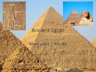
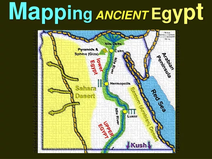
MappingANCIENT Egypt Turn your blank map into an information-packed resource
MappingANCIENT Egypt Step One: Outline the borders of modern Egypt with colored pencil using a dashed line
MappingANCIENT Egypt Step Two: Outline the borders of the areas controlled by Ancient Egypt with a dashed line using a different color
MappingANCIENT Egypt Mediterranean Sea Step Three: Label surrounding regions and bodies of water Arabian Peninsula Red Sea
MappingANCIENT Egypt Mediterranean Sea Step Four: Indicate the rival civilization to the south; Kush Arabian Peninsula Red Sea Kush
MappingANCIENT Egypt Mediterranean Sea Step Five: With a blue colored pencil, trace and label the Nile River Arabian Peninsula Nile River Red Sea Nile River Kush
MappingANCIENT Egypt Mediterranean Sea Step Six: With a green colored pencil, trace the lands made fertile by the Nile River Arabian Peninsula Nile River Red Sea Nile River Kush
MappingANCIENT Egypt Mediterranean Sea Step Seven: Using the blue colored pencil, illustrate and label the Nile Delta Nile Delta Arabian Peninsula Nile River Red Sea Nile River Kush
MappingANCIENT Egypt Mediterranean Sea Step Eight: Draw a star and label the city of Cairo Nile Delta Cairo Arabian Peninsula Nile River Red Sea Nile River Kush
MappingANCIENT Egypt Mediterranean Sea Step Nine: With a red colored pencil, draw in the 6 Cataracts along the Nile River and add them to the legend. Cairo Arabian Peninsula Nile River Red Sea Nile River Cataracts Kush
MappingANCIENT Egypt Mediterranean Sea Step Ten: To the left of Cairo, draw three pyramids and write the label next to it Nile Delta Pyramids & Sphinx (Giza) Cairo Arabian Peninsula Nile River Red Sea Nile River Cataracts Kush
MappingANCIENT Egypt Mediterranean Sea Step Eleven: Label, and lightly shade in the Sahara Desert Nile Delta Pyramids & Sphinx (Giza) Cairo Arabian Peninsula Nile River Sahara Desert Red Sea Nile River Cataracts Kush
MappingANCIENT Egypt Mediterranean Sea Step Twelve: Label and lightly shade in the Arabian Desert and Sahara Desert Nile Delta Pyramids & Sphinx (Giza) Cairo Arabian Peninsula Nile River Sahara Desert Red Sea Nile River Eastern (Arabian) Desert Cataracts Kush
MappingANCIENT Egypt Mediterranean Sea Step Thirteen: Label Upper and Lower Egypt Nile Delta Pyramids & Sphinx (Giza) Cairo Lower Egypt Arabian Peninsula Nile River Sahara Desert Red Sea Nile River Eastern (Arabian) Desert Upper Egypt Cataracts Kush
MappingANCIENT Egypt Mediterranean Sea Step Fourteen: In the space provided under your map, take two or three sentences to explain what geographical features protected Ancient Egypt from invaders. Nile Delta Pyramids & Sphinx (Giza) Cairo Lower Egypt Arabian Peninsula Nile River Sahara Desert Red Sea Nile River Eastern (Arabian) Desert Upper Egypt Cataracts Kush
MappingANCIENT Egypt Mediterranean Sea Step Fifteen and Sixteen: Draw in at least two other symbols of items found in Egypt or the surrounding areas (cities, landmarks, animals, etc.) Nile Delta Pyramids & Sphinx (Giza) Cairo Lower Egypt Arabian Peninsula Nile River Sahara Desert Red Sea Nile River Eastern (Arabian) Desert Upper Egypt Cataracts Kush