Download
1 / 64
640 likes | 842 Views
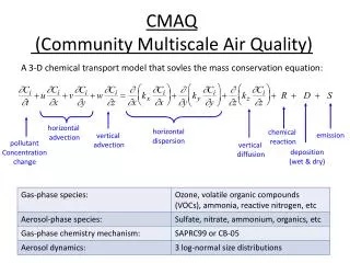
Status of the NOAA WRF-CMAQ Regional Air Quality Forecast System. Jeff McQueen, Pius Lee, Marina Tsildulko, Geoff DiMego Sarah Lu and Bert Katz NOAA/NCEP Environmental Modeling Center Rohit Mathur, Hsin-Mu Lin, Daiwen Kang, George Pouliot U.S. EPA/ORD/ASMD and NOAA/OAR/ARL.

E N D
Status of the NOAA WRF-CMAQ Regional Air Quality Forecast System Jeff McQueen, Pius Lee, Marina Tsildulko, Geoff DiMego Sarah Lu and Bert Katz NOAA/NCEP Environmental Modeling Center Rohit Mathur, Hsin-Mu Lin, Daiwen Kang, George Pouliot U.S. EPA/ORD/ASMD and NOAA/OAR/ARL
2006 Developments • WRF Transition • Improved vertical coupling • Continued convective mixing & vertical layering tests • Continued lateral boundary condition tests • CMAQ Improvements • Optimized Advection scheme • Emissions upgraded for 2006 • AQF system retrospective & Real-time testing • July 2005 with experimental CONUS configuration • Real-time Verification • Spatial map comparisons to observations (03 & PBL hgt) • Inclusion of AIRNOW PM 2.5 observations • Use of ACARS, ESRL Profilers for PBL hgt verification • Inclusion of NESDIS GASP AOD products • Improved Analyses & Visualizations • Focus group, TEXAQS06 & SHENAIR projects • Vertical gas-phase and aerosol chemistry profiles
NAM-WRF Implementation • Major Components of Upgrade Package for NAM • Replace Eta Model with WRF version of NMM(Nonhydrostatic Mesoscale Model) • WRF Common Modeling Infrastructure • Non-hydrostatic dynamics • Use of hybrid sigma-pressure vertical coordinate with top at 2 mb • Refined advection, diffusion, numerics and physics • Replace Eta 3D-Var analysis with Gridpoint Statistical Interpolation (GSI) analysis • Unified (regional + global) 3D-Variational analysis adapted to WRF • Begin use of background errors based on WRF-NMM to 2 mb • Use of new variable for moisture analysis • Use of tendency in constraint terms • Use of dynamically retuned observational errors
NAM-WRF Implementation • Model initialization • Begin use of: • high resolution (1/12th degree) SST • high resolution (4 km) snow • Common specification of terrain, land-sea mask • Data assimilation changes • Use of bias-corrected observed precipitation analysis values in land-surface physics • Start assimilating • WSR-88D Level II radial wind data • GPS-Integrated Precipitable Water (IPW) • NOAA-18 radiances • Drop use of • GOES Precipitable Water retrievals • SSM/I Total Precipitable Water retrieval
ground ground Hybrid vs Step (Eta) Vertical Coordinate Systems Ptop Ptop η= 0 Pressure domain δ = 0 Sigma domain η = 1 MSL δ= 1 HYBRID Step (Eta)
Forecast Domains (2006) 259 grid cells • CONUS “5x” Domain • WRF-CMAQ • WRF-CMAQ-PM East “3x” Domain 268 grid cells
Improved Vertical Coupling(Hsin-Mu Lin, EPA) NAM 60L CMAQ 22L http://virtualskies.arc.nasa.gov/weather/tutorial/tutorial2d.html
Summer 2006 Evaluations(Errors not uncovered w/retro tests) • Operation Runs: Ozone over-predictions esp. under cool, cloudy conditions • WRF-Post temperature interpolation to CMAQ sigma errors • Sigma level 1 and 2 temps were too warm for thermally stable conditions (near lakes, water bodies) • STATUS: Crisis Fix implemented on July 28. 2006 • Small impact on forecast Slightly less ozone produced • PREMAQ Emission Processing • Some arrays for mobile, point, area, biogenic sources were undefined • Some point and mobile source emission files not upgraded for 2006 • STATUS: Implemented 18Z August 22, 2006 • Preliminary tests show minor impact
Summer 2006 Evaluations(Errors not uncovered w/retro tests) • Experimental/Developmental Runs: Significant under-prediction esp. near coasts, lakes • PREMAQ Biogenic Isoprene emissions • Turned off for tight vertical coupled codes • STATUS: Implemented in exper/dev runs on Aug. 5 • Major impact on forecast Increased photochemistry esp. in California • PREMAQ Emission Files and Processing • Some arrays for mobile, point, area, biogenic sources were undefined • Some point and mobile source emission files not upgraded for 2006 • STATUS: Corrected in exper/dev run on August 5 • Preliminary tests show minor impact • PREMAQ Jacobian Calculations for vertical diffusivity • Status: Should be implemented at 12Z on Sept. 5, 2006
July 17,06 Ozone event (06Z forecast)1h daily max valid 06z 7/18/06 5X tight coupled 3X loose coupled 5X forecasts 1 category less than 3X in general
Impact of Isoprene Emissions Error on Exper. CMAQ R. Mathur, EPA MAX Hrly O3 Differences (Corr Tight – Old Tight)
Additional NAM ChangesImplemented August 15, 2006 • WRF-NAM PBL often too cool and moist esp. in complex terrain and over/near water bodies • Over intense storms off West coast • Corrections Made: • Increased vertical mixing for stable PBLs • Turned on horizontal mixing at and near all coastal points and in complex terrain • Fixed SST initializations at Western Lakes • Double horizontal diffusion everywhere: to be implemented on Sept. 5, 2006
NAM vs NAM-Y evaluations2m Temperature forecast error (12 Z Cycle) OBS NAM NAM-Y EASTERN U.S. WESTERN U.S.
NAM vs NAM-Y evaluations2m DewpointTemperature forecast error (12 Z Cycle) OBS NAM NAM-Y EASTERN U.S. WESTERN U.S.
NAM vs NAM-Y evaluations 10m WIND forecast error (12 Z Cycle) OBS NAM NAM-Y EASTERN U.S. WESTERN U.S.
NAM-CMAQ Aug 3 case Cloud cover 2 m Temperature The importance of met driver to CMAQ forecasts
NAM-CMAQ Aug 3 case Cloud cover 2 m Temperature O3 NAMY-NAM The importance of met driver to CMAQ forecasts
CMAQ under-predictions in California NAM Vertical Motions NAM Temperature coast coast
California Ozone Forecast Inland Along Coast Across Coast coast N S
Impact of Lateral Boundary ConditionsCMAQ 3X (w/ GFS Top LBC) vs CMAQ 5x (w/ static, clean LBC) Chicago Wallops Island Figure 2. Ozonesonde measurements (black line) and CMAQ operational 3X (red dashed) anddevelopmenat CONUS (green dashed) ozone predictions for Wallops Island, VA at 18 UTC Feb. 10, 2006. Ozone reported in ppb. Model sigma pressure used as vertical axis.
Summary • Major errors in WRF-Post, biogenic emissions, PREMAQ code and emission files • Not found with retrospective testing • Delayed by final WRF retro configurations and Summer 05 retro WRF NDAS runs • True NAM & NAM-Y and vertical structure impact can be assessed on/after August 5 when major isoprene error was corrected
Proposed Plans for FY07 • Current CONUS gas-phase run operational • CONUS gas + aerosol run • Examine impacts of vertical resolution • “ “ Tight horizontal coupling • “ “ Convective mixing scheme in CMAQ • “ “ Direct WRF turbulence predictions for CMAQ PBL mixing (e.g: TKE, exchange coefficients, Zi calculations…) • Developmental run to cover Alaska, Hawaii ?? • Include wild fire smoke emissions • GFS-GOCART aerosols for LBCs • ShenAir evaluation
BACKUPS • BACKUPS
Max.-8hr O3: 7/19/06 Isoprene Fix Tight Old Tight Loose
Loose Max. 8 O3 7/19/06 Old Tight Isoprene Fix Tight
2005 Retrospective Analyses • Time Periods • 12Z July 9, 2005 – 12Z July 20, 2005 - Hurricane Dennis, East coast near exceedences • 12Z August 23, 2005 – 12Z August 30, 2005 - West Coast event • Configuration: • WRF V2.1 initialized with fully cycled IC (restart file) • Use WRF EGRD3D post file to collapse to CMAQ vertical coordinate (22-40 layers, LCC C grid) • All runs with CMAQ gas-phase chemistry on CONUS domain
RETROSPECTIVE CONUS TESTINGRuns: P. Lee, M. TsidulkoAnalysis: R. Mathur, D. Kang, J. Pleim,… • 2005 Base: 2005 Operational run • S0: Reflects changes due to NAM-X (WRF) • S1: S0 + Increased vertical layering • S2: S1/S0 + Convective mixing based on NAM-X conv. Precip rates • S3: S1/S0 + PV ozone BCs • S4: S1/S0 + new mass continuity constraints • S5: S2+S3 (Conv + LBCs) • S6: S2+S4 (Conv + mass cont) • S7: S2+S3+S4 (Conv + LBCs + mass cont)
2005 Retrospective NAM-Eta and WRF(NAM-X) Verification • From 12 Z run, 24-48 hr forecasts • UPA : 00 Z valid time • Low level temperatures: Sfc-700 mb • Low level Winds • Low level RH • 24 h Precip valid at 48 hrs
Precipitation Verification EAST WEST
Retros Verification 2 m Temperature EAST U.S. WEST U.S.
2005 Retros Verification 10 m RH EAST WEST
2005 Retros Verification 10 m Winds WEST EAST
Real-time Ozone Verification • From 2005 3X and 5X 48 hr forecasts • 12 UTC cycle only • AIRNOW hrly ozone monitors • RMSE, BIAS, threat scores, hit rates
FVS O3 1h Aver. Aug 20051x - 3x - 5x over 3x domain RMSE by Forecast Hour BIAS
Summer 2005 PerformanceSub-Region Bias 3X SE NE 1X LMV NE, SE Regions 1X vs 3X 3X All Regions
Objective Verification July 26, 2005 Case • Operational Run : NE US • 8 hr daily max • Experimental Run: Eastern 2/3 US • 8 hr daily max
CONUS Domain Performance July 12, 2005 Case • 8h daily max obs vs predicted
CONUS Domain Performance July 12, 2005 Case Hurricane Dennis
NCEP Graphical Products Predicted Sfc Ozone (1, 8h & daily max) NAM Ventilation Index NAM PBL hgt
Air Quality ForecastingUser Access • Operational Eastern U.S. Domain : • Public: NDGD and TOC ftp server • Surface ozone predictions • State Forecasters: HPC web site • Sfc O3 & met plots • Daily (2pm) conference calls • HPC forecasters trained • Experimental Domain (CONUS): • Focus group: EMC web site • Expanded met plots (pbl hgt, sw rad, ventilation index….) • Sfc & upper level O3 and precurser plots (NOx, NOy,CO,SO2) • Developmental Run (CONUS Aerosols) • Sfc PM
Data Assimilation &Global System Tasks • CMAQ data assimilation • Plan for surface ozone assimilation • Correlate sfc ozone w/ precursers (Nox VOCs) • GFS-Chem: Provide Regional boundary conditions • Ozone: • Include tropospheric product/loss rate terms • Test reduced ozone chemistry (U.Wisc-RAQMS) • Begin testing assimilation of AURA/OMI • CMAQ LBC impact studies • Aerosols: • Include NASA-GOCART reduced biomass burning/dust and emission processes • Begin testing assimilation of MODIS & AURA/TESS • CMAQ LBC impact studies
Potential Collaborations • Evaluation of NCEP WRF-CMAQ ozone & aerosol simulations • Experimental & rural obs networks (eg: ETOS, AERONET, REALM lidar network) • GOES/MODIS AOD satellite evaluation • Assimilation of AIRNOW data • Improved cloud mixing, aqueos chemistry PBL coupling with WRF-CMAQ • Testing of WRF-Chem on-line system
Operational Requirements • Driven by NCEP Operational Meteorological Model (NAM-WRF) • I/O Formats: • Only machine binary, GRIB and BUFR, disk space limitations • Time Requirement: • 12 Z 48 hour forecast available by 17:25 Z (1:25 pm EDT) • 06 Z 48 hour forecast available by 13:00 Z ( 9 am EDT) • 65 IBM Power 4 procs available • 12 Z start after Eta is complete (14:30 Z) • Robustness: • Thoroughly tested & evaluated with retrospective and real-time experimental runs • Available to NWS Gateway, NDGD: 99% reliability, 24x7 NCEP support • Accuracy: 90% exceedence hit rate