Download
1 / 3
30 likes | 39 Views
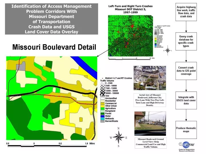
This study utilizes Missouri Department of Transportation crash data and USGS land cover data overlay to identify access management problem areas on major corridors. The analysis focuses on left turn and right turn crashes in Missouri DOT District 5 from 1997-1999, specifically on Missouri Boulevard in Jefferson City and Manchester Road in the City of Manchester and Ballwin. By visualizing and prioritizing these problem areas using GIS, effective access management strategies can be developed.

E N D
Identification of Access Management Problem Corridors With Missouri Department of Transportation Crash Data and USGS Land Cover Data Overlay Left-Turn and Right Turn Crashes Missouri DOT District 5, 1997-1999 Aerial view of Missouri Boulevard, Jefferson City. Five-Lane With Two-Way Left-Turn Lane and High Driveway Density. Missouri Boulevard Ground Level View--Strip Commercial Land Use and High Traffic Volume.
Using GIS Crash Data To Identify Access Management Priority Corridors:Manchester Road (Missouri Hwy. 100) Highway 100: Manchester Road City of Manchester City of Ballwin
Using GIS Crash Data To Visualize Access Management Problems Example Corridor: US 6 (Euclid/Douglas Avenues) In Des Moines, Iowa • On relatively well-managed portion of • corridor to the West (far left-hand side of map)--few mid-block • crashes, intersection crashes are the majority • On less-managed portions of • corridor (center and right-hand • side of map)--mid-block • crashes are much more common Des Moines River Bridge (No Access) • Height of stacked bars • reflects the number of • crashes at locations along • US 6 in 1996 • Crash locations on other routes are shown as green dots