Download
1 / 22
250 likes | 974 Views
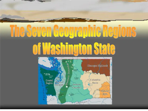
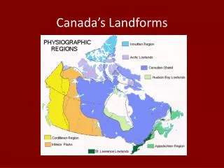
Canada’s Landform Regions. Landform Region Map. Canadian Shield. Formation Volcanic mountains (igneous rock) Erosion leveled mountains Glaciers scraped soil and made lakes. Notice the scratches in the rock. They were caused by Glaciers retreating. . Canadian Shield. Resources

E N D
Canadian Shield Formation • Volcanic mountains (igneous rock) • Erosion leveled mountains • Glaciers scraped soil and made lakes. Notice the scratches in the rock. They were caused by Glaciers retreating.
Canadian Shield Resources • Metallic minerals • Dense forests • Hydroelectric power • Clay belt farming
Canadian Shield Population • Scattered • Few large cities • Many tourists in summer A boulder in the Northwest Territories. It was deposited here by a retreating glacier.
Appalachian Mountains Formation • Folded mountains • Eroded rounded mountains • Natural harbors as sea level rose • The boulders were deposited by glaciers
Appalachian Mountains Resources • Fishing • Metallic Minerals • Farming (potatoes) Population • 1/10 of Canada’s population • 4 cities over 100,000 • Declining coastal cities Notice the rounded mountains
Appalachian Mountains • Cape Breton Highlands • The mountains have been flattened by erosion
Great Lakes – St. Lawrence Lowlands Formation • Sedimentary Rock • Niagara Escarpment • Glaciers dumped soil, carved great lakes • Flat farm land A typical farm in Ontario
Great Lakes – St. Lawrence Lowlands Resources • Farming • Skiing and hiking along the escarpment • manufacturing
Great Lakes – St. Lawrence Lowlands Population • Heavily populated along major waterways • 2/3 of Canada’s population • Largest cities: Toronto & Montreal The city of Toronto from the air. Notice the lack of hills. Also notice the smog.
Interior Plains Formation • Flat sedimentary rock • Glaciers brought thick soil • 3 eroded levels Farmland near the Red River in Southern Manitoba
Interior Plains Resources • Farming (wheat & grain) • Cattle ranching • Oil & natural Gas Population • 2 cities of about 1 million people (Calgary & Edmonton)
Western Cordillera Formation • Folding (Rocky Mts) • Volcanic (Coastal Mts) • Lava flows (interior Plateaus) Mountains of the Yukon. Notice the jagged peaks. If you looks carefully, you will also see glaciers.
Western Cordillera Resources • Recreation/tourism • Coal • Metallic minerals • Forests • Fruit orchards A glacier-fed lake in Jasper National Park in Alberta
Western Cordillera Population • 1/8 of Canada’s Population • Most in Vancouver and Victoria • Coastal and valley settlements
Arctic Lowlands Formation • Sedimentary rock scraped bare by glaciers • Rising sea levels are covering it Tundra in Nunavut. Notice the flat land and strewn rocks.
Arctic Lowlands Resources • Oil and Natural Gas Population • Extremely small and scattered population
Innuitian Mountains Formation • Folded sedimentary rock • Covered by glaciers The dramatic cliffs of Ellesmere Island, Nunavut.
Innuitian Mountains Resources • Oil and Natural Gas Population • small and scattered population
Hudson Bay Lowlands • A wetland known as a muskeg in Northern Manitoba
Hudson Bay Lowlands • A forested bog outside Gilliam, Manitoba