Download
1 / 25
250 likes | 501 Views
Modeling Stream Flow of Clear Creek Watershed-Emory River Basin. Presented by Divya Sharon GEOG-5650 Instructor:Dr.Peter Li. Outline. Introduction Background Motivation Models Data requirement Methodology Results Conclusion. INTRODUCTION.

E N D
Modeling Stream Flow of Clear Creek Watershed-Emory River Basin Presented by Divya Sharon GEOG-5650 Instructor:Dr.Peter Li
Outline • Introduction • Background • Motivation • Models Data requirement • Methodology • Results • Conclusion
INTRODUCTION • Hydrology-Study of Water in the natural or disturbed environment • Factors influencing Watershed Hydrology-Land use, climate and soil conditions. • Need for Stream Flow Modeling-Surface run off-source of non-point source pollution. • Affects land surface characteristics, water balance and hydrologic cycle. • Relationship between land use types and quantity and quality of water.
HYDROLOGIC CYCLE http://www.uwsp.edu/geo/faculty/ritter/images/hydrosphere/hydrocyc.jpg
Background • BASINS-developed by US EPA for watershed based analysis and TMDL development. • Integrates with models HSPF, SWAT, AQUATOX,AGWA…. • HSPF-Hydrologic Simulation Program, Fortran • Watershed model that simulates non-point source runoff and pollutant loadings for a watershed. • Continuous simulation model with fixed, user selected, time steps .
Motivation • To learn modeling software first hand • To experience the modeling process • To understand the various parameters associated with hydrologic process better.
Methodology • Download data-Basin's data extension • Watershed Delineation-Automatic Delineation • Creation WDM file-Weather data management file • Creation of UCI file • Flow calibration • Model validation
Data Requirements • Delineation-NHD, DEM, Watershed Boundary (Hydrologic cataloging Unit layer) • UCI file-Requires-Land use, Reach file, DEM, USGS hydrologic unit boundaries. • Environmental Monitoring data- locations of water quality monitoring stations, weather stations and USGS gaging station.
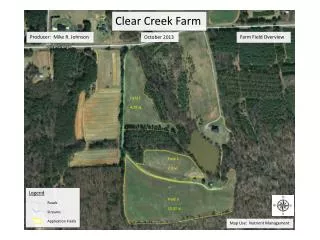
STUDY AREA • Clear creek watershed part of the Emory River Basin and it lies in cumberland plateau • The land use in the clear creek watershed is approximately 78% forest, 17 % agriculture, 6% developed areas
HSPF MODEL • Three sub modules-Pervious Land(PERLND), Impervious Land (IMPLND) and Reaches (RCHRES).
Parameters for Simulation • Hourly, daily precipitation data- http://www1.ncdc.noaa.gov/pub/orders/609796812343dat.txt Flow calibration-2001-2004 Flow Validation 2005 Annual Volumes and Seasonal Volumes Parameters Estimation
Conclusion • HSPF model gives good results • The model simulates the flow well. A correlation coefficient of 0.823 is obtained. • To generate different scenarios. (to track the effect of land use changes on stream flow)
References • http://www.epa.gov/ost/basins/ • http://www1.ncdc.noaa.gov/pub/orders/609796812343dat.txt • http://www.watershedhydrology.com/ • Arthur, Benjamin Bryan., 2003. “Testing the transfer of hydrologic model parameters across scales: Modeling the Emory River, Daddy’s creek, and Crooked fork watersheds” • Patuxent Watershed Model 2005, Internet, April 2005, Available: http://www.chesapeakebay.net/info/model.cfm