Download
1 / 28
280 likes | 468 Views
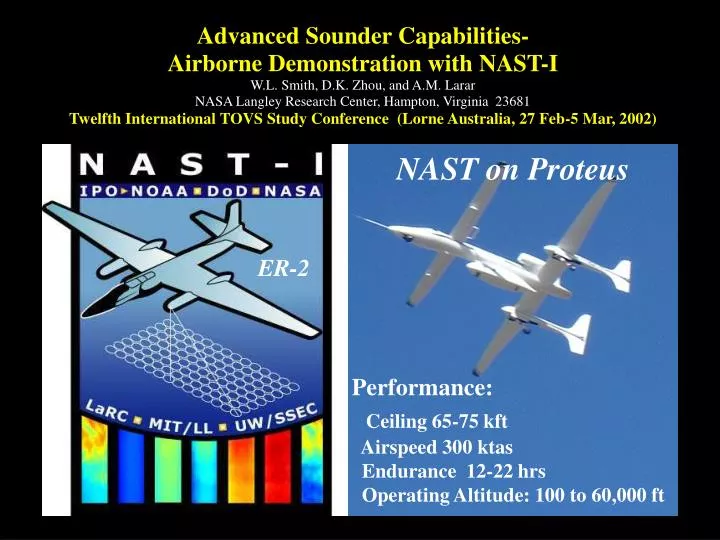
Advanced Sounder Capabilities- Airborne Demonstration with NAST-I W.L. Smith, D.K. Zhou, and A.M. Larar NASA Langley Research Center, Hampton, Virginia 23681 Twelfth International TOVS Study Conference (Lorne Australia, 27 Feb-5 Mar, 2002). NAST on Proteus. ER-2.

E N D
Advanced Sounder Capabilities- Airborne Demonstration with NAST-I W.L. Smith, D.K. Zhou, and A.M. Larar NASA Langley Research Center, Hampton, Virginia 23681 Twelfth International TOVS Study Conference (Lorne Australia, 27 Feb-5 Mar, 2002) NAST on Proteus ER-2 Performance:Ceiling 65-75 kft Airspeed 300 ktas Endurance 12-22 hrs Operating Altitude: 100 to 60,000 ft
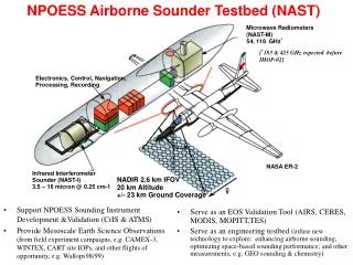
NPOESS Airborne Sounder Testbed (NAST) IR interferometer ( NAST-I ) Spectral Range:3.5 – 16microns Spectral Resolution:>2000 (0.25cm-1)
Spectral Coverage Comparison NAST-I /IASI CrIS AIRS/CrIS GIFTS-LW GIFTS-SW GIFTS CO CO CO2 N2O N2OCH4 H2O N2O CH4 H2O H2O N2O CO2 H2O CO2 O3 O3 CO2 H2O NAST-I Spectral Coverage Encompasses all future satellite sounders
NAST-I Observes 3-Dimensional Structure With High Spatial Resolution and Radiometric Accuracy p
Optimal Regression Retrieval Approach for NAST-I Application • R = radiance • = surface emissivity Bs = surface Planck radiance • = transmittance • s = surface transmittance • * = (s)2 / Ps = surface pressure Pac = aircraft pressure S = number of sample profiles = radiance deviation from the mean M = covariance matrix of E = eigenvectors of M – EOFs C = radiance EOF amplitudes A = {Ts, , T, q, ...} parameters K and k = regression coefficients = emissivity EOF amplitudes
NAST-I Spectrum and Retrieval Channels NAST-I Spm RTVL Chnls
Retrieval Accuracy Vs EOF Number 10 Full Noise 26 58 1/2 Noise
Retrievals for Two Different EOF #s 48 EOFs Radiosonde 23 EOFs
Radiosonde Validation Andros Is. Bahamas, Sept 12, 1998 Raob NAST Altitude (km) Relative Humidity (%) 3km Distance (75 km)
Spectral H2O Sensitivity H2O Sensitivity [dTB(,p)/dlnq(p)]
Water Vapor Retrieval Sensitivity LW-side of H2O Band 75 km SW-side of H2O Band
Spatial (~22km) & Temporal (~2-3hr) Temperature Variation Over Purcell ARM CART-Site Sounding Validation C P D Sfc Temp (21Z) A P B Space & Time Variability Sfc Temp (19Z)
PROTEUS NAST-I Flight Over CART SiteLoop 1 [18:06 – 19:50 UT, March 19, 2000]
PROTEUS/NAST-I Flight Over CART SiteLoop 2 [19:50 – 21:24 UT, March 19, 2000]
VERTICAL PROFILE COMPARISONS NOV 30 NOV 30 NOV 30 DEC 05 DEC 05 DEC 05
COMPARISON WITH GSFC-SRL (DEC. 5, 2000) Loss of Sensitivity NAST-I cross section is produced by profiles from 7 high altitude passes over Lamont OK. GSFC-SRL Ground-based Scanning Raman LIDAR produced from 10 min averages at Lamont OK Time Average
Proteus NAST-I Vertical Cross-section (CLAMS 7/12/01) 16.0 UTC 13.8 14.9 This flight demonstrates the ability to observe the spatial moisture structure below a scattered and semi-transparent Cirrus cloud cover
Effective Surface Temperature (July 26, 2001) GOES image High dense convective clouds over North Carolina and low cumulus clouds over the Delmarva peninsula
Vertical Cross-section (July 26, 2001) Clouds Clouds CLOUDS CLOUDS CLOUDS Clouds IR Window Image Along Track
Surface Skin Temperature (July 14, 2001) 296.52º K ( = 0.54º K)NAST-I retrieved (within 0.1 Lat. and Lon.) 297.45º K NOAA buoy site CHLV2 measured (i.e., the bulk SST). The cool “skin”, observed by NAST-I, relative to the sub-surface water, observed by the buoy, is expected as a result of evaporative cooling.
Surface Emissivity (July 14, 2001) Seawater Emissivity Lab. measured (solid) NAST-I retrieved (dashed) NAST-I validation (dots)
Surface Skin Temperature Along Track IR Image along track NPOESS Aircraft Sounding Testbed (NAST) soundings over Alaska from the ~15km flight altitude of the Proteus (March 20-21, 2001). Upper panels show flight track and cross-section. (Note the updrafts and downdrafts seen in the water vapor at 7-9 km.) Bottom panels show comparisons with North Slope CART-site radiosondes. March 20, 2001 March 21, 2001
Can CAT Be Measured ? Temp NAST Near Fairbanks AK (3/21/01; 1-2 GMT) 200 km Moisture Weak Turbulence Signatures at 150 mb Downdrafts:Warm&Dry Updrafts:Cold & Moist Temp Moisture Strong Turbulence Signatures at 300 mb Temp Moisture Moisture No Turbulence Signatures at 500 mb
Summary • The NAST provides high spatial resolution radiance measurements which can be used to validate the radiometric accuracy and retrieval products of advanced IR sounding systems • High spatial resolution features of atmospheric temperature, moisture, and clouds can be retrieved from NAST radiances • Lower tropospheric water vapor profiles depend on measurements along the shortwave side of the 6.3 m H2O band • High spectral/spatial resolution sounders can profile above an opaque overcast cloud cover and above and below thin and/or broken clouds • Surface skin temperature and emissivity can be retrieved simultaneously from the spectral radiance measurements and this is important for the retrieval of accurate lower tropospheric moisture profiles • Atmospheric turbulence might be observed with very high spatial resolution advanced sounders