Download
1 / 26
270 likes | 517 Views
Improving Cadastre: Development of a Workflow Prototype Using ESRI’s Parcel Fabric. Pennsylvania State University – GEOG 596A Linda M. Foster , MGIS Candidate Justine Blanford , Advisor July 2011. What is a Cadastre?. Land Records History / Importance.

E N D
Improving Cadastre: Development of a Workflow Prototype Using ESRI’s Parcel Fabric Pennsylvania State University – GEOG 596A Linda M. Foster , MGIS Candidate Justine Blanford, Advisor July 2011
What is a Cadastre? Pennsylvania State University - GEOG 596A - Spring 2011 - Capstone Proposal – Linda M. Foster
Land Records History / Importance • property cadastres /land registration systems date back to 14th century BC in Egypt • a digital cadastre system allows for the • management of public infrastructure • response to natural disasters • homeland security • economics – (e.g. tax collection and other revenues) currently high property transaction fees & mortgage crisis • in the U.S. land records administered by local governments Pennsylvania State University - GEOG 596A - Spring 2011 - Capstone Proposal – Linda M. Foster
How Rapid City Uses Land Records • maintain ownership and tax information • zoning and planning designations • development of future land use • track annexations • maintain corporate boundaries • planning future transportation routes • Infrastructure Management • sanitary sewer system • water system • other asset management
Why is Improvement Needed? • because Rapid City’s parcels dataset accuracy hasn’t kept pace with the accuracy of other basemap layers (i.e. aerial imagery) Pennsylvania State University - GEOG 596A - Spring 2011 - Capstone Proposal – Linda M. Foster
Rapid City Parcels Dataset History Parcels digitized from plats Scales: 1:7,200, 1:2,400, 1:1,200 Control: USGS quadrangle section corners (7.5 minute) Lines aligned to rectified but not ortho-corrected aerial photos Microstation CAD Parcels converted to ESRI ArcInfo Coverage Control: USGS DLG & DRG (1:24,000) Lines aligned to USGS DOQQ & Rapid City ortho-photography ESRI GIS Software Parcels converted to single county-wide SDE feature class Maintenance of parcels by COGO input and other editing techniques ESRI GIS Software Migrate parcels to parcel fabric Maintain cadastre and improve accuracy ESRI GIS Software 1989 2000 2003 2011 Errors: aligning property to aerial photo Errors: alignment was better in east than in west of county; removal of tax parcel lines to match DLG section lines Errors: remain uncorrected Errors:to reduce errors Data exist as a representation Need improved accuracy Pennsylvania State University - GEOG 596A - Spring 2011 - Capstone Proposal – Linda M. Foster
Sources of Error Original dataset developed in 1989 OBVIOUS • Relevance • Areal Cover • Accessibility • Density of Observations • Age of Data • Format • Map Scale • Cost Data in .dgn, coverage & ArcSDE formats Scales used: 1:1,200, 1:2,400, 1:7,200 Cost consideration during development NATURAL VARIATIONS • Accuracy of Content • Positional Accuracy • Sources of Variations in Data TYPES OF ERROR No surveyed control points incorporated PROCESSING • Numerical Errors • Errors in Topological Analysis • Classification and Generalization of Problems • Digitizing and Geocoding Errors Different formats = different math solutions Human interpretation of data Source: Foote and Huebner (1995) Pennsylvania State University - GEOG 596A - Spring 2011 - Capstone Proposal – Linda M. Foster
Problems with Error • current dataset is a representation • public and city staff use data daily • problems visually or spatially analyzing features as they relate to property boundaries • Need to Improve Accuracy • cost prohibitive to hire a consultant to reconstruct • not enough manpower in the GIS Division to re-build • need to leave some version of parcels in service at all times • up until now, no suitable alternative Pennsylvania State University - GEOG 596A - Spring 2011 - Capstone Proposal – Linda M. Foster
Key Considerations for Building and Managing Cadastre Data • develop layers with higher spatial accuracy • update and modify cadastral layers continuously, so as to increase accuracy of cadastre with time • store legacy data while constructing the maps from oldest to newest surveys • retrieve easily Source: Bhowmick et al., 2008
How to Accomplish? use ESRI’s Parcel Fabric Source: ESRI 2011 Pennsylvania State University - GEOG 596A - Spring 2011 - Capstone Proposal – Linda M. Foster
About the Parcel Fabric 2000 ESRI Releases Survey Analyst – collaborative effort with LeicaGeosystems 2007 ESRI Releases Cadastral Fabric – collaborative effort with Geodata of Australia 1999 ESRI Releases ArcGIS 8 – birth of geodatabase 2010 ESRI Releases ArcGIS 10 with Parcel Fabric in software core 2004 ESRI Releases ArcGIS 9 1994 FIG Cadastre 2014 Vision 1999 FGDC Cadastral Standard 2004 ArcGIS Cadastre 2014 Data Model Vision Published 1992 Geodata Australia developing GeoCadastre Pennsylvania State University - GEOG 596A - Spring 2011 - Capstone Proposal – Linda M. Foster
Project Objectives Develop and Evaluate a Workflow to: • improve accuracy of the cadastre & related dataset • evaluate success of improvement • test success of workflow Pennsylvania State University - GEOG 596A - Spring 2011 - Capstone Proposal – Linda M. Foster
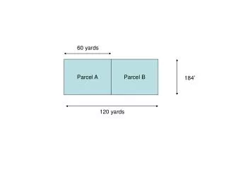
Study Area – Test Data Sample to be Used Pennsylvania State University - GEOG 596A - Spring 2011 - Capstone Proposal – Linda M. Foster
Workflow Development STEP 1 Building Framework STEP 2 Preparing and Loading Data STEP 3 Parcel Adjustment STEP 4 Accuracy Assessment STEP 5 Adjustment to associated layer User Feedback Pennsylvania State University - GEOG 596A - Spring 2011 - Capstone Proposal – Linda M. Foster
STEP 1 Building Framework • review • ESRI documentation • other literature • identify steps necessary to use parcel fabric • gather feedback Pennsylvania State University - GEOG 596A - Spring 2011 - Capstone Proposal – Linda M. Foster
STEP 2 Preparing and Loading Data • prepare data • planarize lines and curves • verify topology • load data • points, lines & polygons • match control points • capture workflow for client to repeat Pennsylvania State University - GEOG 596A - Spring 2011 - Capstone Proposal – Linda M. Foster
STEP 2 Preparing and Loading Data (Cont.) bearing & distance calculated on import Pennsylvania State University - GEOG 596A - Spring 2011 - Capstone Proposal – Linda M. Foster
STEP 3 Parcel Adjustment • adjust parcels to surveyed control points • use least-squares adjustment built into parcel fabric Source: ESRI 2011 Source: ESRI 2011 Pennsylvania State University - GEOG 596A - Spring 2011 - Capstone Proposal – Linda M. Foster
STEP 4 Accuracy assessment • error evaluation • compare adjusted fabric parcels to independently developed AutoCAD parcels Pennsylvania State University - GEOG 596A - Spring 2011 - Capstone Proposal – Linda M. Foster
STEP 5 Adjusting an associated layer • apply adjustment to associated layer – zoning Pennsylvania State University - GEOG 596A - Spring 2011 - Capstone Proposal – Linda M. Foster
Workflow Evaluation • work with City GIS Division staff to test usability of the workflow • incorporate their feedback into the workflow Pennsylvania State University - GEOG 596A - Spring 2011 - Capstone Proposal – Linda M. Foster
Summary of Results • evaluate the project for pitfalls, lessons learned, best practices and if the objectives were met Pennsylvania State University - GEOG 596A - Spring 2011 - Capstone Proposal – Linda M. Foster
Project Timeline • July 7, 2011 – Proposal Presentation / Proposal Submittal • June 22 – July 31, 2011 – Refine workflow, gather and incorporate client feedback, finish testing • July 31 – August 30, 2011 – finish paper and prepare final presentation • September 1, 2011 –Present work at GIS in the Rockies Conference, Denver CO Pennsylvania State University - GEOG 596A - Spring 2011 - Capstone Proposal – Linda M. Foster
Acknowledgements • Pennsylvania State University – Justine Blanford • Ferber Engineering Company • Rapid City/Pennington County GIS Division – Don Jarvinen • ESRI Land Records Division – Chris Buscaglia
References • Bhowmick, A., Bodnar, N., Farmer, D., Tirunagari, P., & Van Pelt, D. (2008). Cadastre Management the GIS Way. Professional Surveyor Magazine, Volume 28, Issue 8. Retrieved April 8, 2001 from http://www.profsurv.com/magazine/article.aspx?i=2198 • ESRI (2011). Desktop 10 Help. ArcGIS Resource Center Desktop 10. Retrieved May 18, 2011 from http://help.arcgis.com/en/arcgisdesktop/10.0/help/index.html • Foote, K. & Huebner, D. (2000). Error, Accuracy, and Precision. The Geographer’s Craft. Retrieved from http://www.colorado.edu/geography/gcraft/notes/error/error_f.html • Rapid City GIS Division. (2009). Rapid City Corporate Limits [metadata]. City of Rapid City, South Dakota: GIS Division.