Download
1 / 52
520 likes | 545 Views
Join our engaging forum to learn about NH's broadband mapping initiatives, funding, and future steps. Interactive sessions for residents and businesses. Explore BTOP funding and partnerships with UNH and regional planning commissions.

E N D
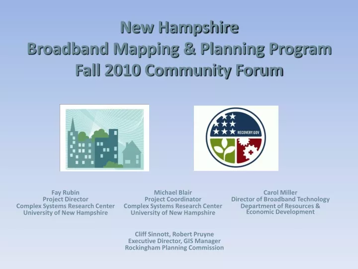
New Hampshire Broadband Mapping & Planning Program Fall 2010 Community Forum Fay Rubin Project Director Michael Blair Project Coordinator Complex Systems Research Center University of New Hampshire Carol Miller Director of Broadband Technology Department of Resources & Economic Development Complex Systems Research Center University of New Hampshire Cliff Sinnott, Robert Pruyne Executive Director, GIS Manager Rockingham Planning Commission
Overview – Rockingham Planning Commission • Established by its member towns under RSA 36:45-58 as advisory body for regional planning • Exists as public non-profit entity and political subdivision of the State. • The RPC is one of 9 regional planning commissions in NH • RPC’s planning district includes 27 communities (not all of Rockingham County) • Governed by representatives from each member town or city – i.e. “the Commission” • Voluntary member organization- municipalities choose to join
RPC Region (27 of 37 Towns in Rockingham County) RPC; 06-15-00; Page 3
REGIONAL PLANNING COMMISSIONS Region 1: North Country Council Bethlehem, NH Michael King, Exec. Director Region 2: Lakes Region Planning Commission Meredith, NH Kimon Koulet, Exec. Director Region 3: Upper Valley Lakes Sunapee Council Lebanon, NH Christine Walker, Exec. Director Region 4: Southwest Region Planning Comm. Keene, NH Tim Murphy, Exec. Director Region 5a: Central NH Regional Planning Comm. Concord, NH Michael Tardiff, Exec. Director Region 5b: Southern NH Planning Commission Manchester, NH David Preece, Exec. Director Region 5c: Nashua Regional Planning Commission Merrimack, NH Kerrie Diers, Exec. Director Region 6: Rockingham Planning Commission Exeter, NH Cliff Sinnott, Exec. Director Region 7: Strafford Regional Planning Commission Dover, NH Cynthia Copeland, Exec. Director
Overview – continued • Purposes: – To assist member towns with individual planning, – To carry out regional planning, – To foster coordination between towns – To establish and maintain technical capacity necessary to fulfill our mission • Areas of Focus – land use, conservation, natural resources planning – regional transportation planning – housing; economic development – hazard mitigation planning – GIS – a supporting technology for all work elements
Agenda 6:00 – 6:15 Welcome and Introductions Review of Meeting Agenda and Goals Overview of BTOP Funding 6:15 – 6:45 New Hampshire Broadband Mapping & Planning Program 6:45 – 7:15 Data Collection Activities 7:15 – 7:30 Additional NH Broadband Initiatives 7:30 – 8:00 Next Steps Q&A
Meeting Goals The meeting goals are: – To inform regarding the NH Broadband Mapping & Planning Program – To inform regarding the State’s broadband goals and initiatives – To conduct “interactive” mapping and surveying of broadband availability at participants’ residences/businesses – To inform regarding next steps of the broadband initiatives
Broadband Funding under the American Recovery and Reinvestment Act of 2009 The Recovery Act appropriated $7.2 billion and directed the Department of Agriculture's Rural Utilities Service (RUS) and the Department of Commerce's National Telecommunications and Information Administration (NTIA) to expand broadband access to unserved and underserved communities across the U.S. in order to increase jobs, spur investments in technology and infrastructure, and provide long-term economic benefits. The result: 1. RUS Broadband Initiatives Program (BIP) – loans/grants for broadband infrastructure projects in rural areas; NTIA Broadband Technology Opportunities Program (BTOP) – grants to fund broadband infrastructure, public computer centers and sustainable broadband adoption projects. 2.
Broadband Technology Opportunities Program (BTOP) “The U.S. Congress has appropriated $4.7 billion to establish Broadband Technology Opportunities Programfor awards to eligible entities to develop and expand broadband services to rural and underserved areas and improve access to broadband by public safety agencies …” • $ 3.9 billion - for broadband expansion • $250 million – innovative programs that encourage sustainable adoption of broadband services • $200 million – build capacity at public computing centers, including community colleges and public libraries • $10 million - transfer to the Office of Inspector General for the purposes of BTOP audits and oversight • $350 million - development and maintenance of statewide broadband inventory maps. (Grants to all 50 states, 5 territories, and District of Columbia.)
New Hampshire Broadband Mapping & Planning Program Partners University of New Hampshire: • GRANIT/Complex Systems Research Center Regional Planning Commissions: • Central New Hampshire Regional Planning Commission • Lakes Region Planning Commission • Nashua Regional Planning Commission • North Country Council • Rockingham Planning Commission • Southern NH Regional Planning Commission • Southwest Region Planning Commission • Strafford Regional Planning Commission • Upper Valley Lake Sunapee Regional Planning Commission NH Department of Resources and Economic Development NH Office of Energy and Planning
The NH GRANIT System: State GIS Clearinghouse • GIS Data Development • Image Processing • Data Hosting • Data Distribution • Web Services - Online Mapping • Application Development • Spatial Analysis • Cartography • Training • Technical Support • Needs Assessments
NHBMPP – Initial Funding (start date: 1/2010) Mapping Program (Years 1-2): • Identify areas (census blocks) served by current broadband infrastructure – by type of technology and speed of transmission. Identify areas unserved or underserved Planning Program (Years 2-5): • Utilize the mapping and community forums results to build momentum for regional broadband plans • Create broadband stakeholder groups to identify barriers to deployment of broadband services, promote collaboration with service providers, and facilitate information sharing
NHBMPP Amended & Supplemental Application: Eligible Activities NTIA has bundled a number of eligible activities into 6 categories: Data Collection and Related Activities State Broadband Capacity Building Technical Assistance Local/Regional Technology Planning Teams Application Usage and Development Programs to Improve Computer Ownership and Internet Usage 14
NHBMPP – Amended & Supplemental Activities (start date: 1/2011) Mapping & Planning Program (Years 2-5): • Continue to identify areas served by current broadband infrastructure – by type of technology and speed of transmission • Rural address creation • Satellite dish surveying • Web based crowd sourcing • Wi-Fi source mapping Supplemental Activities (Years 2-5): • Technical Assistance to local boards through web resources (OEP & UNH Cooperative Extension) • Statewide Broadband Capacity Building (DRED & UNH) • Local / Regional Broadband Planning
Key Definitions Broadband - Advertised speeds of at least 768 kbps downstream and 200 kbps upstream Unserved area – One or more contiguous census blocks where >= 90% of households (HH’s) lack access to facilities-based terrestrial BB service, fixed or mobile (at minimum speed noted above) Underserved area - One or more contiguous census blocks where one of the following factors is present: • <= 50% of HH have access to facilities-based terrestrial BB service (at minimum speed noted above) • no fixed or mobile BB provider advertises transmission speeds of at least three mbps; or • the rate of BB subscribership for the area is <= 40% of HHs.
Census Geography Block: • Smallest unit of geography for data collection • Bounded by visible features Tract: • Subdivision of county • Optimum size of 4,000 people, but can range from 1,500 – 8,000 • Initially, goal is for homogeneity w/r to population characteristics Source: www.census.gov/www.cengeoga.pdf
Census Geography Block: • Smallest unit of geography for data collection • Bounded by visible features Tract: • Subdivision of county • Optimum size of 4,000 people, but can range from 1,500 – 8,000 • Initially, goal is for homogeneity w/r to population characteristics
Scheduled Mapping Activities Acquire/Process Service Provider Data Obtain service coverage data from providers: broadband availability, technology, speed, infrastructure, and for wireless – spectrum used Inventory Community Anchor Institutions/State Agencies Map location of each CAI, and conduct telephone survey to collect broadband access information Conduct Analysis Compile the provider information into statewide maps displaying areas served by type of technology and speed tier Share and Display Information Develop consumer reporting and mapping website(s): www.iwantbroadbandnh.org
Source Data Sets • Service provider data • GRANIT base map layers • Census derivatives – roads, census blocks • Aerial photography • Parcel data • Tabular data from assorted sources (DHHS master list of health care facilities) • Vegetation • Topography
Progress to Date • Development of guidance/protocols • Identification of active service providers (70+) • Execution of NDAs with providers • Acquisition and processing of provider data sets • Development of CAI and preliminary state anchor institution data set • Development of public web site (iwantbroadbandnh.org) • Promotion of project through public forums, press releases
Example of Service Area: Terrestrial Mobile Wireless
Signal Propagation Modeling Using Cellular Expert software (www.cellular-expert.com) to predict signal strength. Note: This data was generated for display purposes only, and does not represent the actual coverage area of any service provider.
Broadband Availability in New Hampshire Based on data reported as of: September, 2010
Community Anchor Institution Mapping Based on data reported as of: September, 2010
Community Anchor Institution Mapping Based on data reported as of: September, 2010
Community Anchor Institution Mapping Based on data reported as of: September, 2010
Community Anchor Institution Mapping Distribution by Type of Technology Distribution by Advertised Downstream Speed
Data Verification Varies by data set but will include one or more of following: • Checks on internal consistency of data, e.g. logical checks • Collection of speed test data via web • Survey(s) of businesses/households • Purchase of commercial data sets • Community forums
Initial Speed Test Results
Get Involved: www.iwantbroadbandnh.org
Data Collection Instructions • Complete written broadband availability survey • Identify town in which you reside • Locate residence on map • Place dot on map indicating residence location • Number dot on map with survey form number (e.g. 15 not 8A-15) • Network with other attendees while all surveys are mapped
Reminder • Fill out and return broadband survey • Sign-in on meeting roster
Additional Broadband Initiatives In New Hampshire
Department of Resources and Economic Development George Bald, Commissioner Roy Duddy, Interim Division Director DED Christopher Way, Business Services Manager Business Resource Center DED Business retention & recruitment, government procurement, energy, employee retention Paul Leary, Chief of Communications Forest and Lands
Funding Priorities (Middle Mile) •New or upgraded service to Community Anchor Institutions (CAI) •Public-Private Partnerships •Bolster growth in economically distressed areas •Commitment to serve Community Colleges •Public Safety Entities •Last Mile component in unserved or underserved areas (20%) •Non-Federal Match that equals or exceeds 30%
New Hampshire Grant Award Round 1 The Bretton Woods Telephone Company, $985,000 grant for 20 Mbps two-way broadband service to all potential customers to stimulate tourism in the area and to substantially improve the local economy. This fiber to the premise service will be available to more than 400 locations.
Network New Hampshire Now Grant Award Round 2 Community, educational, and technology leaders created Network New Hampshire Now (NNHN), to build an integrated open access middle mile and last mile fiber optic network with a focus on unserved and underserved areas of the state. NNHN will significantly increase the capacity and capability of the state’s telecommunications infrastructure while making future last mile build- out easier and less expensive. The business model provides affordable broadband service choices to New Hampshire communities and aligns with all seven BTOP priorities. Grant Request was for $44.5 Million with a $22 Million match. Notified of award 6/30/10.
What does this mean to my community? There is no last mile without middle mile. Phase 1 of many phases. Expand opportunities for education, job training and placement through online platforms. Will help lower the cost for providers to deploy broadband by creating an open access network backbone to enhance competition in underserved markets and help get service to unserved markets utilizing groups like Fastroads.
Broadband: Who is Responsible? Government? The Connect America Fund will not dictate where broadband facilities will actually get built. Should the state get into the business of mandating broadband access? Should there be a new carrier of last resort responsible for Broadband? Service Providers? Should service providers have an obligation to build broadband facilities everywhere regardless of where the business case makes sense? End User? Is universal broadband unrealistic? Should users simply accept the fact that there are limited resources? Is it a choice to live in an area where broadband is not available?
NH Advantage Telecommunications Advisory Board looking at the issue since 2000. Legislation passed July 2009 for Telecom Position. Supportive Governor’s Office and State Agencies and Congressional Delegation. Broadband Action Plan – 2008.
States’ Crucial Role FCC wants states to take a leading role in advancing the National Broadband goals and improving broadband service delivery Coordinate among various public and private entities Provide resources and tools for municipalities Eliminate policy barriers to the physical build-out of infrastructure
State Challenges • Cost – Coverage for unserved and underserved communities remains unfeasible. • Mapping current access – who has it and at what speed. • Physical infrastructure – negotiating federal, state and county jurisdictional issues. • Capacity – only an estimated 15 states have agencies or authorities that focus on Broadband expansion.
State Options • State Universal Service Fund • Tax Credits Incentives • Revolving Loan Fund • Broadband Fund • Technology Fund
Municipal Role •Track broadband in Master Plans •Do a needs Assessment (know what you need) •Rally the people (Need a cheerleader) •Public-private partnerships (don’t go it alone) •Do your part
Next Steps • Analysis of unserved/underserved areas • Development and posting of state maps • Development and hosting of interactive map viewer • Enhanced interactions with service providers – possibly offering them our services • Linkages to planning components • Additional supplemental activities
Community Forum Schedule
Contact Information www.iwantbroadbandnh.org Fay Rubin Project Director - UNH fay.rubin@unh.edu Michael Blair Project Coordinator - UNH michael.blair@unh.edu Carol Miller Director of Broadband Technology - DRED carol.miller@dred.state.nh.us