Download
1 / 23
230 likes | 346 Views
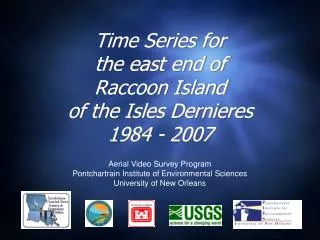
Time Series for the east end of East Island of the Isles Dernieres 1986 - 2007. Aerial Video Survey Program Pontchartrain Institute of Environmental Sciences University of New Orleans. Karen A Westphal.

E N D
Time Series forthe east end ofEast Islandof the Isles Dernieres1986 - 2007 Aerial Video Survey Program Pontchartrain Institute of Environmental Sciences University of New Orleans Karen A Westphal
The Aerial Video Survey Program has been acquiring photography and video of the northern Gulf of Mexico shoreline since 1984. Oblique aerial photography does not produce exact matches due to variations in altitude, camera angle and distance from the shore (and different photographers). Photos that matched well were scaled and aligned to illustrate the landscape changes that have taken place between time periods. Occasionally a pointer or symbol was added to assist with the visual comparison.
Location of East Island, Louisiana East Island is in BICM region “Teche Delta” and BICM segment 36 “East Island”
1986 29º04'25"/90º38'06” View to the west July 23, 1986
1987 29º04'25"/90º38'06” View to the west July 9, 1987
1988 post-Hurricane Gilbert 29º04'25"/90º38'06” View to the west October 12, 1988
1990 29º04'25"/90º38'06” View to the west June 25, 1990
1992 pre-Hurricane Andrew 29º04'25"/90º38'06” View to the west July 9, 1992
1992 post-Hurricane Andrew 29º04'25"/90º38'06” View to the west August 30, 1992
1993 29º04'25"/90º38'06” View to the west June 16, 1993
1994 29º04'25"/90º38'06” View to the west July 26, 1994
1996 post TPCG FEMA project 29º04'25"/90º38'06” View to the west July 17, 1996
2001 2 yr post TE-20 project 29º04'25"/90º38'06” View to the west June 14, 2001
2002 post-Tropical Storm Isodore 29º04'25"/90º38'06” View to the west October 1, 2002
2002 post-Hurricane Lili 29º04'25"/90º38'06” View to the west October 5, 2002
2004 pre-Hurricane Ivan 29º04'25"/90º38'06” View to the west September 13, 2004
2004 post-Hurricane Ivan 29º04'25"/90º38'06” View to the west September 18, 2004
2005 post-Hurricane Katrina/Rita 29º04'25"/90º38'06” View to the west September 30, 2005
2007 29º04'25"/90º38'06” View to the west (~234º) April 20, 2007
10 Years • 1986 • 1996
11 Years • 1996 • 2007
21 Years • 1986 • 2007
Relevant Coastal Restoration Projects • Isles Dernieres Restoration East Island. State Project Number:TE-20 Project Priority List (PPL):01 Federal Sponsor:Environmental Protection Agency (EPA) Project Type:Barrier Island Construction Completion Date:1999 Description: The project objective is to restore the coastal dunes and wetlands of the Eastern Isles Dernieres. Approximately 3,925,000 cubic yards of sand were dredged from adjacent waters and used to build a retaining dune which was then hydraulically filled to create an elevated marsh platform. Sand fences and vegetation were also installed to stabilize the sand and minimize wind-driven transport. http://dnr.louisiana.gov/crm/coastres/projectlist.asp