Download
1 / 17
180 likes | 388 Views
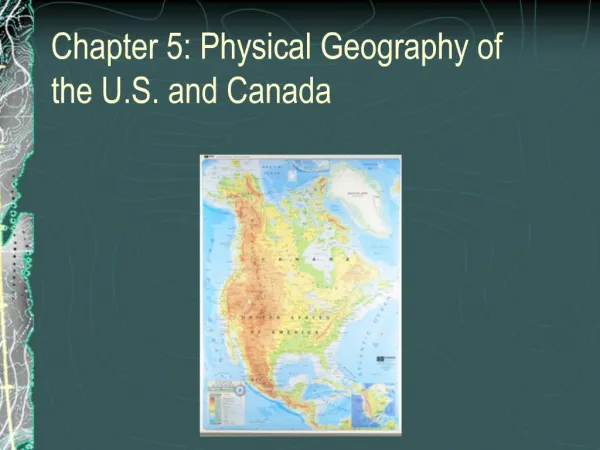
THE PHYSICAL GEOGRAPHY OF THE U.S. and CANADA. THE LAND. Key Terms: Divide Headwaters Tributary Fall-line Fossil fuel Fishery Aquaculture. WESTERN MOUNTAINS, PLAINS, and PLATEAUS. Pacific Ranges-collision b/t plates Ex: Sierra Nevada, Cascade Range, Alaska Range

E N D
THE LAND • Key Terms: • Divide • Headwaters • Tributary • Fall-line • Fossil fuel • Fishery • Aquaculture
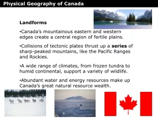
WESTERN MOUNTAINS, PLAINS, and PLATEAUS • Pacific Ranges-collision b/t plates • Ex: Sierra Nevada, Cascade Range, Alaska Range • Mt. McKinley- Alaska Range (20, 320 ft.) • Rocky Mountains • Link Canada and US (NM to Alaska) • Dry Basins & Plateaus • Fill land b/t Rockies and Pacific Ranges • Colorado Plateau- Grand Canyon • East of Rocky Mts.- Great Plains
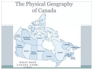
EASTERN MOUNTAINS and LOWLANDS • East of Mississippi River • Appalachian Mts. (oldest in US) • Canada • Canadian Plains • Edge is the Canadian Shield • Located on the Hudson and James Bays • Anchors the continent
ISLANDS • Both US and Canada have these • In US • Hawaii • Continental Islands- submerged parts of the continental shelf
WATER SYSTEMS • Make Canada and US prosperous • In US • Continental Divide- high ridge that determines the direction in which rives flow • East of Divide- toward the Arctic Ocean, Hudson Bay, the Atlantic, or the Mississippi • West of Divide- Pacific • Headwater- source of the river • Ex: Colorado and Rio Grande (Rocky Mts) • Tributaries- smaller water systems that connect to larger rivers • Mississippi- Longest River in US (2,350 ft)
LAKES and OTHER WATERWAYS • Glacial Dams- Canada- Great Bear and Great Slave Lake • Glacial Basins- Great Lakes • Rich in coal, iron and other materials • Links to inland and coastal waterways= $$$$$$ • Ex: Great Lakes and St. Lawrence Seaway sys. • Canals, St. Lawrence River and other waterways link the Great Lakes to the Atlantic • INDUSTRY
NATURAL RESOURCES • Canada and US- Petroleum and Natural Gas • US= Texas; Canada=Alberta • Mineral Resources • US= Rockies: gold, silver, copper • Canadian Shield= iron and nickel • Timber and Fishing • Trees are renewable • Atlantic-Pacific-Gulf of Mexic0 • Fisheries- place for catching fish • Grand Banks- Canada’s best fishing spot • 139,000 sq. mi. • Problem: overfishing • Solution: Aquaculture= fish farms
THE CLIMATE and VEGETATION OF THE U.S. and CANADA • KEY TERMS: • HURRICANE • CHAPARRAL • PRAIRIE • SUPERCELL • TIMBERLINE • CHINOOKBLIZZARD
THE SOUTHERN CLIMATES • Subtropical, tropical, desert, Mediterranean • 25°N to 40°N • Warm and Wet • Humid-Subtropical • Ex: The Everglades; hurricanes • Extreme Southern tip of Florida • Tropical= distinct dry season (Winter)
SOUTHERN CLIMATES (cont) • Warm and Dry • Have rain-shadow effect- dry desert on leeward side of mountain • Plateaus and Basins b/t the Rockies and Pacific Ranges • Ex: Death Valley • Mediterranean- Central and Southern California • Mild, wet Winters & hot, dry Summers • Vegetation in this area= chaparral
NORTHERN CLIMATES • Interior • Ex: Great Plains- Humid Continental • Bitterly cold Winter, hot Summer • Vegetation • Prairie- treeless grasslands in Great Plains • Weather • Supercell- violent T-storms w/tornados and winds of 300+ mph • Dust Bowl- 1930s drought
HIGHLAND CLIMATE • Due to elevation • Ex: Rocky Mountains and Pacific Range • Timberline • Elevation above which trees cannot grow • Springtime • Chinook- warm dry wind that blows through the area in Spring, melting the snow
COASTAL CLIMATE • Northern California to Southern Alaska • Features • Over 100 inches of rain annually • Winter- overcast and rainy • Summer- cloudless • Coniferous forests
HIGH LATITUDE CLIMATE • Canada and Alaska • Features: • Frigid Winter • Blizzards- heavy snow w/ winds above 35 mph • Coniferous trees from Newfoundland to the Yukon Territory • Layers of ice and snow over 2 miles thick • Perspective • A mile is 5,280 ft.