Download
1 / 1
10 likes | 125 Views
Landscape use and collision risks at different scales. Juvenile White-tailed Sea Eagles studied by GPS satellite telemetry at Smøla wind-farm. Torgeir Nygård 1 , Kjetil Bevanger, Espen Lie Dahl, Roel May, Ole Reitan All authors: Norwegian Institute for Nature Research, Trondheim, Norway

E N D
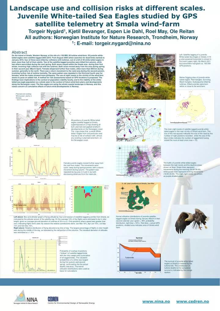
Landscape use and collision risks at different scales. Juvenile White-tailed Sea Eagles studied by GPS satellite telemetry at Smøla wind-farm • Torgeir Nygård1, Kjetil Bevanger, Espen Lie Dahl, Roel May, Ole Reitan • All authors: Norwegian Institute for Nature Research, Trondheim, Norway • 1: E-mail: torgeir.nygard@nina.no Abstract • Onthe island of Smøla, Western Norway, at the site of a 150 MW, 68 turbine wind-farm, 59 juvenile white-tailed eagles were satellite-tagged 2003-2010. From August 2005 (when searches for dead birds started) to January 2010, four of these were killed by collisions with turbines, out of a kill of 40 white-tailed eagles in total, more than half of them adults. Two of the satellite-tagged juveniles were killed first autumn, while two others were killed during the next spring. Both sexes stayed within the Smøla area during their first winter, involving high collision risk with the turbines. Both sexes moved away from the area during spring in their second year (March-April). Females dispersed further than males, often more than 800 km during summer, generally to the north. There was a return movement to the natal area during the second autumn, involving further risk of turbine mortality. The same pattern was repeated in the third and fourth year for females, while the males showed more philopatry. The use of night roosts in the vicinity of the wind-farm seems to pose an added risk. A method for risk assessments based on GPS locations is proposed. The findings have implications in the context of population viability locally, and to the viability of the white-tailed sea-eagle population as a whole seen in the context of future wind-farm plans and developments along the Norwegian coast. The Sea eagles are using the whole coastal landscape in Norway, and this raises concern of cumulative effects of future wind developments in Norway. Left: Satellite tagging of a juvenile White-tailedSeaEagleonSmøla. A 70 g solar-poweredtransmitter is shown in theinsert (upper right). By March 2011 the transmitters had given ca. 150,000 GPS positions. Below:Taggingsitesof juvenile white-tailedeagles. Red triangles: Surviving. Black triangles: Subsequenlykilled by turbines. Killed juveniles werebornwithin or close to thewind farm. S s A a Sss Planned and existingWind-power plants in Norway The main night roosts of satellite-tagged juvenile white-tailed eagles in the near vicinity of Smøla wind-farm. The size of the red squares indicates the size of the roost by the number of night positions recorded , while the size of the blue circles indicates the number of tagged bird having visited the roost at least once (max = 15). All positionsof juvenile White-tailedeaglessatellite-tagged at Smøla, superimposedon a mapshowing all built, plannedand appliedwindfarm-developmentsontheNorwegiancoast. The map shows that juvenile White-tailedEagles from oneparticular area may be at risk ofcollisionwithalmostanyexisting or plannedwind-farmontheNorwegiancoast. The traffic of juvenile white-tailed eagles between the nigh roosts and the daytime areas shown as lines. Green lines represent movements during the morning (04:00-08:00), while purple lines represent evening movements (16:00-20:00). The main night roosts are shown as purple-shaded areas. Female juvenile eaglesmovedfurtheraway from the nest than males. The movementswerecyclic; away during spring/summer, with a returmmovement during autumn. The patternwasrepeated during year 2,3 and 4, butwithdecreasingdistances from the natal site. Rotor-swept area Kernelutilisationdistributionsof juvenile satellite-taggedeagles at Smøla during January-March in theirsecondcalendaryear (green = 95% probabilitydistribution, lightblue = 50%). Red dots= actual GPS positions, shaded area indicates area of Smøla wind farm. Leftabove: Box-andwhiskergraphof flying altitude by hour and seasonofstatellite-tagged juveniles from Smøla, as indicated by thealtitude sensor ofthesatellite-tag. On theaverage 14% oftheflightswereestimated to be in rotor height, given an averagegroundelevationofturbinesof 20 m.a.s.l. Onlypositionswhere speed wasgreaterthan zero (indicatingflight) wereused. By seasonthe relative contributionswere: Jan-Mar 18%, Apr-Jun 15%, Jul-Sep 12% and Oct-Dec 16%. Right above: Relative distributionofflying elevationsby time ofday. The largestpercentageofflights in rotor-heightwasduring themiddleoftheday, as indicated by the red portionofthecolumns. The standard deviationofaltitudeswasestimated at +/- 9 m. Probabilityofoverlapofpositions (”strikes”) ofsatellite-taggedbirdswiththerotor-swept area (cumulativeof all taggedbirds). The calulatedprobabilitiesof a strike waslargest during first autumn and second spring, confirmed by thetheactualdeaths (red dots). The kernelutilisationdistributionswere used as basis for calculations The survivalofjuvenile white-tailedeaglesat Smøla is lowered by theturbinekills. The contributionofturbinedeaths to thecumulativesurvival is indicated by theorangesection.