Download
1 / 10
100 likes | 148 Views
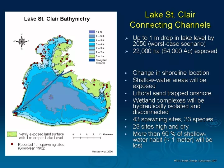
Explore the impact of long-term water level changes on fish spawning habitats in Lake St. Clair, using NOAA's fine-scale bathymetry data. The study highlights potential effects on species diversity and wetland functions due to invasive species and altered water levels. Discover how thresholds like low water levels can lead to habitat loss and wetland expansion.

E N D
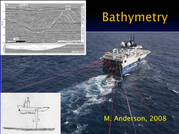
NOAA 1-meter Bathymetry Additional Bathymetry
NOAA Chart 14850_1 0 - 0.25 m light blue 0.25 - 0.50 m med blue 0.50 - 0.75 m dark blue Goodyear et al. (1982) Spawning Sites Based on same Raw Bathymetric Datasets Fine Scale Bathymetry?
NOAA Chart 14850_1 0 - 0.25 m light blue 0.25 - 0.50 m med blue 0.50 - 0.75 m dark blue Goodyear et al. (1982) Spawning Sites Based on same Raw Bathymetric Datasets NOAA Chart Removed Fine Scale Bathymetry?
Reported Lake St. Clair Spawning Locations (Goodyear et al. 1982) Summary list of species that use spawning and/or nursery sites potentially affected by long-term reductions in Lake St. Clair water levels (Goodyear et al. 1982). Entries are ordered by the number of sites used as spawning habitat by each species. Individual sites may used by multiple species during different times of the year. Species highlighted in gray may be more severely affected by changes in water-level regime and temperature than other species. Lake St. Clair
Lake St. Clair Wetlands Potential expansion of coastal and embayed wetlands, but: Wetland functions/ diversity may be severely compromised by invasive species…
Thresholds and Coping Zones • Lake St Clair thresholds • Low Water 173.9 m to 174.2 m (25% to 50% loss fish spawning habitat); Significant expansion of Cattail/ Phragmites wetlands; Significant loss of shallow-water habitats • High Water …………TBD