Download
1 / 9
100 likes | 271 Views
National Soil Quality Monitoring. Field Guide. Inventory and Monitoring Toolbox ’06 FY ‘07 projects Soil Moisture Compaction in rocky soils National Soil Quality Monitoring Field Guide Watershed Soil and Air Soil Moisture Compaction. SDTDC Soils Projects Submitted. WSA and IM

E N D
National Soil Quality Monitoring Field Guide
Inventory and Monitoring Toolbox ’06 FY ‘07 projects Soil Moisture Compaction in rocky soils National Soil Quality Monitoring Field Guide Watershed Soil and Air Soil Moisture Compaction SDTDC Soils Projects Submitted
WSA and IM Soil Moisture Compaction Follow up to include the National Soil Quality Field Guide (IM) All three projects for FY ‘07 Selected Soil Projects
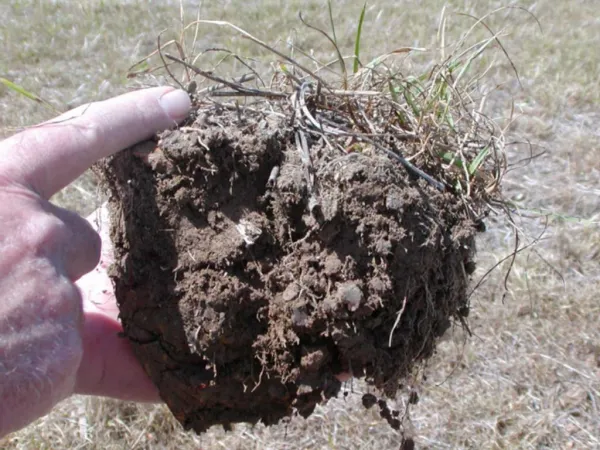
Phase I Develop a soil quality monitoring field guide containing schematic and photographic examples of defined, visually identifiable, soil visual categories. Link to key indicators (erosion, infiltration, nutrient capacity) Goals
Phase II Field guide contains recommended sampling protocols and other tools for conducting rapid, accurate, and consistent pre- and post-project assessments of soil quality. Include a standard protocol (or set) for monitoring soil quality, guidance on project design and determining sampling intensity. Goals
Soil scientist, timber sale administrators, silviculturists and fuel specialist for use in project planning and environmental analysis. Quantitative indicators of soil quality will be validated and correlated to each of the visual soil disturbance categories (as defined by FS Research and NFS) as part of a regular agency wide soil quality monitoring program. Target Audience
Define the soil visual class categories Identify how they differ nationally, eco-region, etc. soil resilience Weyerhaeuser, R-6, and BC examples Identify how we will link qualitative with quantitative findings. Identify sample sites, can we develop a list of potential photo sites for FY ’07? 1 Yr time frame
Identify link between visual soil classes and soil properties. Identify links to Watershed response/watershed analysis / cwe Identify link to published literature Allow forests/regions to identify the effects of the visual indicators based on their values at risk. Outcomes – Products?
SWRCI- Soil water road condition index. Contains table (Good, fair, poor) and photos of each- can attach ftp site link. Other projects in FY ‘07 Soil Moisture tools-soil strength Compaction Monitoring- what works in different areas. Some SDTDC examples