Download
1 / 12
120 likes | 282 Views
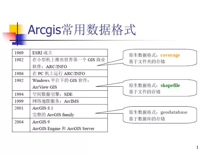
Arcgis 常用数据格式. Shapefile 是 ArcView GIS 3.x 的原生数据格式,属于简单要素类,用点、线、多边形存储要素的形状,却不能存储拓扑关系,具有简单、快速显示的优点。一个 shapefile 是由若干个文件组成的,空间信息和属性信息分离存储,所以称之为 “ 基于文件 ” 。 .shp, .shx, .dbf, .prj, .xml, .sbn, .sbx. .shp 文件,用于存储地理要素的图形数据. .dbf 文件,用于存储地理要素的属性数据. . Shape 数据模型,实现了地理空间数据的存储.

E N D
Shapefile是ArcView GIS 3.x的原生数据格式,属于简单要素类,用点、线、多边形存储要素的形状,却不能存储拓扑关系,具有简单、快速显示的优点。一个shapefile是由若干个文件组成的,空间信息和属性信息分离存储,所以称之为“基于文件”。 • .shp, .shx, .dbf, .prj, .xml, .sbn, .sbx
.shp 文件,用于存储地理要素的图形数据 .dbf 文件,用于存储地理要素的属性数据 . Shape数据模型,实现了地理空间数据的存储
Coverage是ArcInfo workstation的原生数据格式。之所以称之为“基于文件夹的存储”,是因为在windows资源管理器下,它的空间信息和属性信息是分别存放在两个文件夹里。例如,在我的电脑中,所有coverage信息都以文件夹的形式来存储。空间信息以二进制文件的形式存储在独立的文件夹中,文件夹名称即为该coverage名称,属性信息和拓扑数据则以INFO表的形式存储。Coverage将空间信息与属性信息结合起来,并存储要素间的拓扑关系。
当使用ArcCatalog对coverage进行创建、移动、删除或重命名等操作时,ArcCatalog将自动维护他们的完整性,将coverage和INFO文件夹中的内容同步改变。所以对coverage进行操作,一定要在ArcCatalog中进行。当使用ArcCatalog对coverage进行创建、移动、删除或重命名等操作时,ArcCatalog将自动维护他们的完整性,将coverage和INFO文件夹中的内容同步改变。所以对coverage进行操作,一定要在ArcCatalog中进行。
Geodatabase作为ArcGIS的原生数据格式,体现了很多第三代地理数据模型的优势。Geodatabase作为ArcGIS的原生数据格式,体现了很多第三代地理数据模型的优势。 • 在geodatabase中,不仅可以存储类似shapefile的简单要素类,还可以存储类似coverage的要素集,并且支持一系列的行为规则对其空间信息和属性信息进行验证。表格、关联类、栅格、注记和尺寸都可以作为geodatabase对象存储。
Geodatabase 建立个人地理数据库 personal geodatabase 建立要素数据集 feature dataset 建立或导入要素类
数据格式及转换 其他数据格式:cad, mapinfo——> e00, shapefile, coverage e00, shapefile <——> coverage cad ,shapefile, coverage——>geodatabase