Download
1 / 13
150 likes | 295 Views
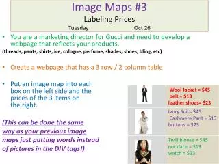
Image Maps. What it Does. Different parts of the image activate different hyperlinks. Server-Side Image Maps. Image displayed by client Program runs on server Client browser sends program the (x,y) coordinates of the mouse click

E N D
What it Does • Different parts of the image activate different hyperlinks Image Maps
Server-Side Image Maps • Image displayed by client • Program runs on server • Client browser sends program the (x,y) coordinates of the mouse click • Program refers to map file which corresponds regions to URLs and invokes appropriate one Image Maps
Server-Side Image Maps • Program runs on server • Disadvantages • Cannot test page without server running • Slow • When you move mouse over hyperlink, you don't see the URL since the web browser doesn't know it; you see URL of the map program itself and an (x,y) coordinate Image Maps
Client-Side Image Maps • No program which runs on server • All processing occurs in browser • Supported by very few browsers Image Maps
Creating Server-Side Image Maps • Map file • Statements • default URL • circle URL x,y radius (radius in pixels) • rect URL x,y x,y • poly URL x1,y1 x2,y2 … xn,yn • point URL x,y • Upper lefthand corner is (0,0) Image Maps
Creating Server-Side Image Maps • Map file • If cursor not in region, than nearest point is used, if there are any • Can have overlapping regions • First statement in map file which covers point is used • If default is used, then you shouldn't have any points Image Maps
Creating Server-Side Image Maps • In your HTML page, include the following, <a href="/cgi.bin/imagemap/ ~xyz/myimage.map"> <img src="image.gif" ismap></a> Image Maps
Creating Server-Side Image Maps • If you don't have an image editor to get coordinates, create the following HTML page <html><head><title>Coordinates</title> </head> <body> <a href="nowhere"><img src="image.gif" ismap> Image Maps
Creating Client-Side Image Maps • All information is part of HTML document • <map>…</map> <map name="mapname"> coordinates and links </map> Image Maps
Creating Client-Side Image Maps • <area>-tag • <area shape="poly" coords="x1,y1,…,xn,yn" href="file.html"> • <area shape="rect" coords="x1,y1,x2,y2" href="file.html"> • <area shape="circle" coords="x,y,radius" href="file.html"> Image Maps
Creating Client-Side Image Maps • Can use target=window_name for frames <map name="books"> <area shape="poly" coords="70,0, 0,37, 0,183, 27,192, 27,48, 103, 9" href="file.html"> </map> <img src="image.gif" usemap="#books"> Image Maps
Creating Client-Side Image Maps • Can use both types of image maps\ <a href="cgi.bin/imagemap/~xyz/myimage.map"> <img src="image.gif" usemap="#books" ismap> </a> • Install myimage.map on server • Include <map name="books">…</map> somewhere on page • Client-side tried first, else does server-side Image Maps