Download
1 / 28
280 likes | 366 Views
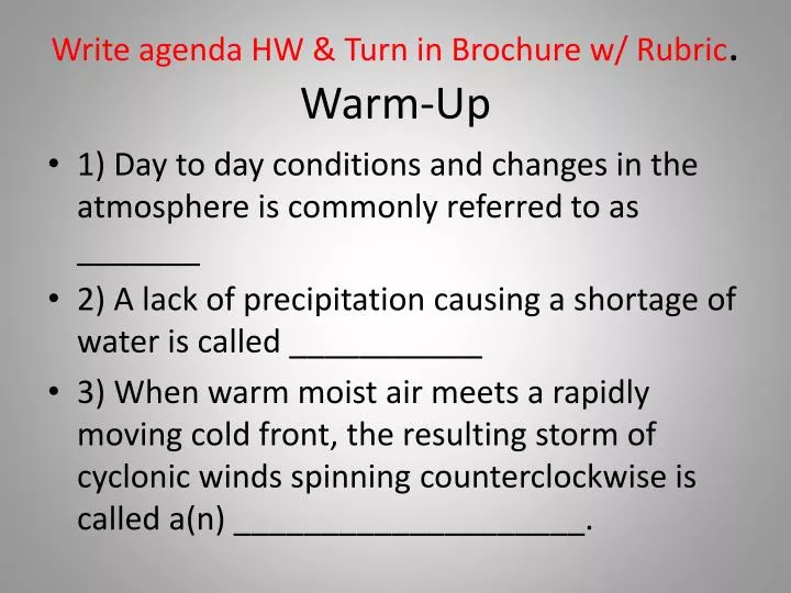
Write agenda HW & Turn in Brochure w/ Rubric . Warm-Up. 1) Day to day conditions and changes in the atmosphere is commonly referred to as _______ 2) A lack of precipitation causing a shortage of water is called ___________

E N D
Write agenda HW & Turn in Brochure w/ Rubric.Warm-Up 1) Day to day conditions and changes in the atmosphere is commonly referred to as _______ 2) A lack of precipitation causing a shortage of water is called ___________ 3) When warm moist air meets a rapidly moving cold front, the resulting storm of cyclonic winds spinning counterclockwise is called a(n) ____________________.
No. 1Georgia’s Geography SS8G1 The student will describe Georgia with regard to physical features and location. (a, b, c, d)
Location: • Georgia is located on the southeastern coast of the U.S. • It’s absolute location is 30°-35° N latitude and 80° - 85° W longitude • It’s relative location is north of Florida, east of Alabama and south of Tennessee • Georgia is located in the Northern and Western Hemisphere • Within Georgia there are five geographic regions and many natural physical features CREATED/PUBLISHEDCincinnati, E. Mendenhall, 1864
The Regions of Georgia are based upon physical geography and are referred to as … naturalhistory.uga.eduHodler, T.W. and H.A. Schretter. 1986. The Atlas of Georgia. University of Georgia Press, Athens.
Blue Ridge • Located in the northeastern corner of the state • Highest mountains in the state – major tourist attractions – Brasstown Bald • Springer Mountain – Appalachian Trail begins here. • First barrier to warm, moist air from the Gulf – provide state with water from precipitation. • Hardwoods, some apples& vegetables
Ridge and Valley • Located between Blue Ridge and Appalachian Plateau regions in north Georgia • Georgia’s “Apple Capital” • Carpet Capital of the world is in Dalton, GA which is located in this region
AppalachianPlateau • TAG corner, northwestern edge of the state on the borders of Tennessee, Alabama and Georgia • Smallest region • CAVES, Canyons, • Lookout Mt with many hardwood forests
Piedmont • Known for its red clay and rolling hills • Home of the state’s capital, Atlanta, and most of the state’s population (½) • North of the fall line • Was once known as the cotton belt • produces wheat, soybeans, corn, poultry and cattle, also much of the states business and industry are found here • Chattahoochee, Flint, Ocmulgee and Oconee Rivers
Fall Line • Boundary between the rolling hills of the Piedmont and softer soil of the Coastal Plain region • Marks the ancient shore line when the Atlantic Ocean once covered the Coastal Plain • Many cities are located along this line that marks a change in elevation • Columbus, Macon, Milledgeville, Thomason and Augusta • Waterfalls provide a good source of power
Coastal Plain • Largest region, located south of the Piedmont and Fall Line – land = 60% of state • Includes the 14 Barrier Islands • The rivers Savannah, Ogeechee, Altamaha, Satilla and St. Marys all empty into the Atlantic Ocean in this region • Many of the State’s valuable crops are farmed in this region’s fertile soil, Vidalia onions, peanuts, pecans, corn and soybeans - Major Farm Region (Upper) • Dense Pine Forest (Lower) – NAVAL Stores & Pulp • Important wetlands such as the freshwater Okefenokee Swamp and the tidewater salt marshes
Farms, Islands, Salt Marshes
SS8G2 The student will explain how Interstate Highway System, Hartsfield-Jackson International Airport, and Georgia's deep-water ports help drive the states economy.
Georgia has a vast network of Interstate Highways which connect many of our borders and cities.
Interstate Highways • Five major interstates include: I-85, I-75, I-20, I-95, I-16 • Interstate highways have limited access and higher speeds compared to regular roadways. This transportation mode moves people and products across our state quickly. • Multiple jobs are required to maintain these roads, support the travelers, and provide for the motor vehicles
Georgia has two major deep-water ports, Savannah and Brunswick. • Not only do these ports provide jobs for Georgians but they move foreign and domestic products into Georgia, (known as container shipping) • These ports are then connected to the Interstate system as well as Georgia’s vast railroad network. • Thereby, providing more jobs to transport and sell these goods.
Waterways • Georgia also has two inland barge terminals , Bainbridge and Columbus • There are also many rivers in Georgia which provided early settlers with a ready means for travel • The largest rivers in Georgia are the Savannah, Chattahoochee, Flint, Altamaha, Ogeechee, Oconee, Ocumulgee, St. Marys and Satilla
Airports • Hartsfield-Jackson International Airport in Atlanta is the busiest airport in the world. This links our local businesses with the world. • Hub for Delta, Airtran, UPS • Georgia has 104 total airports
Railroads • Railroads are connected to the deep water ports and to many cities in Georgia as well as across the country. • Georgia’s major Railroads are CSX, Norfolk Southern, and GDOT short lines.
Georgia’s physical features • There are five physiographic regions • Many rivers, mountains, swamps, marshlands, and barrier islands • Transportation is key to Georgia’s economic development with the many miles of interstate highways, railroads, deep-water ports and airports
For addition information on regions or transportation try these websites • http://naturalhistory.uga.edu/~gmnh/gawildlife/index.php?page=information/regions University of Georgia Museum of Natural History • http://www.n-georgia.com Maps of Georgia • http://www.georgia.org/Pages/default.aspx Georgia Department of Economic Development • www.georgiaencyclopedia.org