Download
1 / 20
200 likes | 215 Views
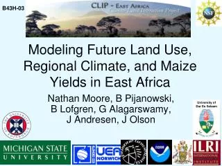
The study by Michigan State University aims to assess how land use/cover changes impact regional climate, characterize land cover for regional climate modeling, and quantify the requirements for accurate modeling. It focuses on the effect of land cover accuracy on climate simulations, linking human land use to climate changes. The study evaluates categorical and continuous land cover changes using various data sources such as LU/C, GLC2000, Africover, and MODIS, along with biophysical variables. Scale ranges from continental to field observations in Nairobi.

E N D
CLIP – Linkages between Land Cover and Regional Climate Jiaguo Qi presenting on behalf of the LC Group (Alphabetically: Jianjun Ge, David Lusch, Joseph Maitima Jennifer Olson, Robin Reid, Nathan Torbick, Jing Wang, Lijian Yang) Michigan Sate University
LC Objectives • To assess land use/cover change impact on regional climate • To better characterize LC as input to regional climate model (RAMS) • To quantify the LC requirement for regional climate modeling. Specifically to assess the effect of land cover classification accuracy on regional climate simulation. This links the human land use to the regional climate • To assess the degree of LCC impact on regional climate • Categorical changes • Continuous changes
Data • LU/C • GLC2000, Africover, IGBP, MODIS • Biophysical Variables • LAI, EVI, DEM, Albedo, LST, and Precip. etc. • Scales • Continental – Case Study/Field-Observations
Nairobi LULC products range in data sources, objectives, classification methods
Assessments and Developing LULC Scheme • Multiple LULC assessments and evaluations • Strengths and weaknesses • Videography over selected ecological gradients • Q-statistic (uses LAI as ‘evaluator’) • Develop LULC Schemes for models • Create hybrid CLIP Cover • LU from Africover, LC from GLC2000 • Crosswalk to LEAF2, biophysical variables
Aquatic grasslands Rainfed herbaceous Bare rock Urban LU/C Videography Assessment Sample Points
LAI from MODIS June 2001 March 2001 Sept 2001 Dec 2001
Climate Model • In this study, Regional Atmospheric Modeling System (RAMS) Version 4.3 is used (Pielke et al., 1992). • It is fully three-dimensional, nonhydro-static; includes interactive nested grid capabilities, supports various radiation, initialization and boundary condition schemes.
RAMS MODEL • Biophysical Parameters • Land – Atmosphere Feedback • Crosswalk to Predetermined Defaults • Albedo • Leaf Area Index • Range of Leaf Area Index • Vegetation Fraction • Range of Vegetation Fraction RS LULC Methods Simulations
Experiment Design • Classification error was added to original GLC2000 dataset at random locations and by random predominant (five) classes, which was increased from 0% to 50% at 5% interval • RAMS was run 11 times with different amount of errors in land cover. These runs are called R00, R05, R10, …., R50.
Leaf Area Index • LAI in RAMS was further improved by incorporating directly monthly 1km MODIS LAI images. • LAI values were reduced to 50% at 5% rate. 11 runs were conducted. • Kain-Fritsch without interior nudging were used.
RAMS new March 15th MODIS RAMS default
THANK YOU • Questions?