Download
1 / 24
240 likes | 485 Views
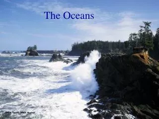
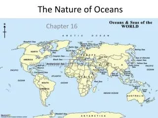
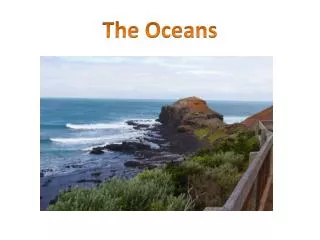
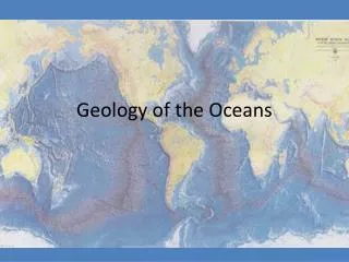
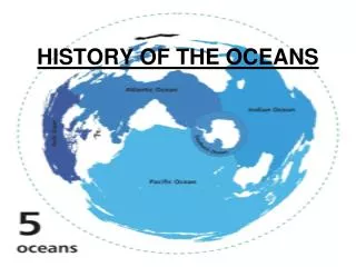
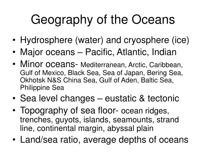
Geography of the Oceans. Hydrosphere (water) and cryosphere (ice) Major oceans – Pacific, Atlantic, Indian Minor oceans- Mediterranean, Arctic, Caribbean, Gulf of Mexico, Black Sea, Sea of Japan, Bering Sea, Okhotsk N&S China Sea, Gulf of Aden, Baltic Sea, Philippine Sea

E N D
Geography of the Oceans • Hydrosphere (water) and cryosphere (ice) • Major oceans – Pacific, Atlantic, Indian • Minor oceans- Mediterranean, Arctic, Caribbean, Gulf of Mexico, Black Sea, Sea of Japan, Bering Sea, Okhotsk N&S China Sea, Gulf of Aden, Baltic Sea, Philippine Sea • Sea level changes – eustatic & tectonic • Topography of sea floor- ocean ridges, trenches, guyots, islands, seamounts, strand line, continental margin, abyssal plain • Land/sea ratio, average depths of oceans
Pacific Ocean • Deepest, oldest, largest, coldest, most tectonically active, ave. depth ~3 miles • Covers ~1/3 of Earth with >½ the water yet small river and sediment discharge, “sediment starved”, remnant of proto-ocean “Panthalassa” • >100K seamounts, ~25K islands; guyots to NW • 3 volcanic systems- hot spots, arc-trench systems, East Pacific Rise (EPR) • EPR (spreading center) continuous from Sea of Cortez, SE below Australia into Indian Ocean • Shrinking by ~5”/yr – narrow continental shelves • Ringed by arc-trench systems (volcanic archipelagos & 4-5 mi deep trenches) “Ring of Fire” shaped like curtained stage
Atlantic Ocean • >¼ Earth’s water • “S” shaped • Volcanics nearly confined to central MAR-passive margins • Arc-trench system on E. margin of Caribbean • Highest temp & salinity of the 3 major oceans due to adjacent Mediterranean Sea • Wide continental shelves receive copious fluvial runoff and tons of sediment annually “sediment gorged” – huge deltas on margins • Only 200 million years old • Average depth – 2.2 mi • “Limestone ocean” due to warm sea temperatures • Significantly fewer islands, seamounts &guyots than Pacific
Arctic Ocean • A land-locked northern arm of Atlantic • Wide shelves, passive margins, mid-ocean ridge connected to Mid Atlantic Ridge • Covered by cryosphere (ice) ½ of the year • Probable oil/gas beneath wide shelves
Indian Ocean • Half/ocean- transition between Pacific & Atlantic models • Shaped like collapsing teepee, India at top • <1/4 Earth’s water • Tectonically similar to Pacific in East- Atlantic in West (both active & passive margins) • Has huge chunk of Africa (Madagascar) and another on the way (Horn of Africa) • Narrow shelves & mid-ocean “inverted Y” ridge connecting to EPR and MAR • East 90° ridge is N/S chain of volcanoes due to hot spot • Huge runoff from Indus, Ganges & Bramaputra rivers from Himalayas with large deltas • “Sediment gorged” Enormous submarine fans extend 1200 to 1500 miles out from deltas onto abyssal plains • ~ 50 million yrs old- youngest of 3 major oceans • Expanding ~ 2”/yr
Marginal Oceans I • Smaller oceans on periphery of major oceans but important politically and economically! • Closely bounded by land so all lie within EEZ of nations • Close to runoff from land so abundant nutrients; foster good fisheries • Greater variation than major oceans in temp & salinity due to small size • All are near tectonic active sites-cultures endure earthquakes, tsunamis, volcanoes regularly
Marginal Oceans II • Four types • Back arc basins- situated between island arc and mainland (sea of Okhotsk, Philippine Sea, Bering Sea, Sea of Japan, S & E China Seas, Caribbean Sea) • Basins trapped between continental blocks (Mediterranean, Black Sea, Gulf of Mexico) • Shallow basins on top of continent (Hudson Bay, North Sea, Baltic Sea) • Linear seaways where mid-ocean ridge intersects continent (Red Sea, Gulf of Aden, Sea of Cortez)
Wegener’s Evidence for Drift • Perfect fit of American/European Atlantic coasts • Matching features as faults & geology across the vast expanse of the Atlantic (3000 miles!) • Karoo system of S. Africa- matching strata, fossils, glaciation of old Gondwanaland (DuToit) • Weakness of Wegener’s thesis- mechanism? sea anchor effect of mountain roots? • Idea disregarded for ~ 40 yrs until exploration of ocean floors provided the answer to a stunned geologic community in the mid to late 1960’s
Drift & PlatesThe solution to moving continents had to wait for ocean research/technology • Very early drifting continents was contemplated mainly due to excellent fit of Atlantic margins in: • 1620 (Sir Francis Bacon) • 1782 (Ben Franklin) • 1908 (FB Taylor) • 1910 (H. Baker) • 1912 & 1929 (Wegener) • 1921 (AL Du Toit, S. Africa) • 1905- magnetic polarity reversals in rocks discovered • 1930’s Meteor (Ger.) discovers MAR in Atlantic with echo sounding between WW I & WW II
Drift & PlatesThe solution to moving continents had to wait for ocean research/technology • WWII – Harry Hess discovers “guyots” in NW Pacific • 1950’s - Heezen & Tharp make map of oceans connecting all ridges to 50k mi. long chain • 1961 – magnetic striping and bilateral symmetry on the MAR SW of Iceland • 1962 – Harry Hess suggests “sea floor spreading” by convection cells • 1963 – Vine & Matthews propose solution to magnetic striping (Morley shafted!) • 1965-69 – DSDP proof of Plate Tectonics
Seven Major Tectonic Plates • Pacific- (largest) moving ~3”/yr toward NW (no continents-horse without rider) • Nazca- ~3”/yr toward east (no continents) • American- ~1.5”/yr west to WSW • Indo-Australian ~2”/yr due north • Antarctic- ~2”/yr north into S. Pacific • Eurasian- ~1.5”/yr toward SE • African ~ stationary today, came from SW
Plate Tectonics • Plates outlined by quakes and volcanoes • Spreading ridges and transform faults • Subduction zones • Continental arcs & island arcs • Mantle plumes (hot spots) [J. Tuzo Wilson]
Age of Oceans I • Embryonic (fetal) – along rift zones, on continents, great faults border deep long valleys (E. African Rift) • Newborn – long, straight expanding inland seaways: when fracture is wide enough oceans invade bringing salt water (Red Sea/Gulf of Aden, Gulf of California)
Age of Oceans II • Youthful (adolescent) – margins far apart but sides still match (like a puzzle), expanding, wide shelves, passive margins, volcanism in center (Atlantic) • Mature (well established) – very large but shrinking ocean, active margins, narrow shelves, shorelines no longer match (Pacific)
Age of Oceans III • Old Age (elderly/retired) – sick, collapsing, narrow opening to other oceans, silled basins, poor circulation, may be anoxic in deep parts (Mediterranean, Black Sea) • Dead (or on life support) – still have water but landlocked (Aral sea, Caspian sea)
Age of Oceans IV • Fossil (extinct) – mountain ranges with compressed marine rocks, raised out of oceans as seaway was crushed between continents [Appalachians, Himalayan range, Alps, Caledonians, Atlas, Urals, Cordillera (Rockies)]
Ancient Oceans • All oceans today are either expanding or contracting • Oceans recycle themselves very quickly -although the Earth is ~ 4.5 billion yrs old, oldest ocean sediments are Jurassic ~ 150 mya (only 5% of Earth’s age)
Ancient Oceans I • Panthalassa “all oceans”- forerunner to present Pacific; once covered >70% Earth’s surface • Iapetus “father of Atlas” - forerunner to Atlantic; destroyed before modern Atlantic formed 200 mya • Tethys “sea of the dead”; “wife of Oceanus”
Ancient Oceans II Tethys • Tethys remnants are widespread limestones and chalk in: US Gulf Coast, S. Europe, N. Africa, Himalayas, E. China • Tethys seaway was destroyed as Indian Ocean formed 50 mya when India merged with Asia • East-west seaway allowed tropical ocean organisms to freely spread to ALL other oceans
Spreading Margins • Ridge/Rise, rifts • Volcanics – basalt, pillows, black smokers • Iceland (for look at ocean floor) • Ophiolites (slab of sea floor) • Economics of ophiolites (Au, Ag, Pt, Cu) • Transform faults – mechanism for ridges turning and bending
Plate Collision Boundaries • Subduction – Benioff zone, partial melting • Volcanic archipelagos (island arc & continental arc) • Trench & arc system • Accretionary wedge and mélange • Fore-arc basin and fore-arc high • Back-arc basin
Plate Collision Boundaries • Subduction – Benioff zone, partial melting • Volcanic archipelagos (island arc & continental arc) • Trench & arc system • Accretionary wedge and mélange • Fore-arc basin and fore-arc high • Back-arc basin
Plate Tectonics • Plates outlined by quakes and volcanoes • Spreading ridges and transform faults • Subduction zones • Continental arcs & island arcs • Mantle plumes (hot spots) [J. Tuzo Wilson]
The Messinian Event • Near-death of the Mediterranean Sea ~ 6 mybp • Gibraltar closed ~ 6mya due to pressure of Spain against Morocco • Because of rapid evaporation and limited fluvial input the sea dried up & remained like Death Valley for ~ 1m.y. (mts on north, desert to south) • Original evidence unraveled by Russians building Aswan Dam in Egypt- deep canyons into Med. Filled with gravel/sand • D.S.D.P. found thick evaporite sediments (salt!) beneath Med. Sea floor that confirmed the event • ~ 5 mybp the “Gibraltar waterfall” refilled the Med. from Atlantic as tectonics destroyed the sill