Download
1 / 14
150 likes | 469 Views
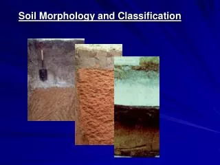
How To Describe or Identify Water Levels Using Soil Morphology. Prepared by Mr. Brian Oram, Professional Geologist, Soil Scientist Wilkes University Environmental Engineering and Earth Sciences Department 84 West South Street Wilkes Barre, PA 18766 http://www.water-research.net.

E N D
How To Describe or Identify Water Levels Using Soil Morphology Prepared by Mr. Brian Oram, Professional Geologist, Soil Scientist Wilkes University Environmental Engineering and Earth Sciences Department 84 West South Street Wilkes Barre, PA 18766 http://www.water-research.net
How to determine the Height of the Seasonal High Water Table But first we must decide what we are really want to know and our application. • Sewage Applications PA – Evidence of Redoximorphic Features • Stormwater Applications – Evidence of Saturation These are the same ? No- Redoximorphic features indicates the zone is saturated and anaerobic and meet all the other requirements for the creation of these features.
Seasonal High Water Table Wastewater Application • Presence of Redoximorphic Features • Direct Observation • Monitoring • Modeling and Water Budget Analysis
Current Law: Pennsylvania Land-Based Disposal • Presence of Redoximorphic Features • Direct Observation • This methodology requires the preparation of detailed soil morphological descriptions.
Current Law: Pennsylvania Land-Based Disposal Depth to Water Table Endosaturation – observed redoximorphic features (f2d to m2p) and direct observation of saturated condition. This means that the soil is saturated and anaerobic to create redoximorphic features at a depth of approximately 2 feet Because the redoximorphic features are more prominent it may be assumed that the soils is saturated and anaerobic for longer periods of time. 2 feet Redoximorphic Features (f2f) Redoximorphic Features (m2p) Saturated Soil- Ponded Water
Monitoring Devices Piezometer – Solid Pipe that is only open at the bottom or a discrete or very small interval Well – Is a solid pipe that is Perforated or slotted over an interval. Measures the Average Piezometeric Pressure over a larger Interval – Measures water table depth under Unconsolidated near horizontal flow Measures the Piezometeric pressure at a discrete point Open Over an Interval Open at the bottom
Monitoring Devices Groundwater Gradient = dh/dl = 10 feet/100 feet dh/dl = 0.10 ft/ft Lines of Equal Potential 90 feet 80 feet 100 ft Direction of Groundwater Flow
Monitoring Devices 120 feet 105 100 Material Saturated 100 feet Groundwater Gradient (Use Piezometers)= dh/dl = (125 – 60)/100 dh/dl = - 0.65 ft/ft (100 feet) 80 80 feet 75 60 Lines of Equal Potential 60 feet Direction of Groundwater Flow Datum
Monitoring Devices 120 105 100 90 80 feet Material Saturated Groundwater Gradient (Use Piezometers)= dh/dl = (120 ft -90feet)/50 feet dh/dl = 0.60 ft/ft 80 (100 feet) 100 feet Lines of Equal Potential 120 feet Direction of Groundwater Flow Datum
Monitoring Where is the Seasonal High Water Table? Based on the presence of Redoximorphic features (f1f) Depth to Water Table = 2 feet Based on Monitoring – SHWT was Only 1.5 feet below grade. What ? Why is it 0.5 feet higher? Possible Answer- The water is not Anaerobic from 1.5 to 2.0 feet Pore Water Anaerobic at > 2.0 feet 1.75 ft 2.0 ft Direct Observation
Methods of Determining Wetness Used by State Agencies Compiled by:Dr.MikeVepraskas, NC State University
CompareFour Methods Variegated Colors- May or may not be Redox related. SHWT at 1.0 feet Monitoring – One Year Monitoring – 1.75 feet Pennsylvania (Redoximorphic Features) SHWT at 2 feet North Carolina and Others (low chorma > 50% of matrix ) SHWT at 4 feet SHWT – Seasonal High Water Table. Redoximorphic Features (f2f)Depletions chorma > 2 Redoximorphic Features (m2p)Depletions chorma < 2 For Land-Based Wastewater Disposal in PA – SHWT at 2 feet
This is Just the Tip of the Iceberg !!! • There are a lot of other issues, such as: • How does the lack of decomposable organic material limit the • formation of redoximorphic features ? • It is possible that the material is saturated and anaerobic, but this does not meet • all conditions for formation of redoximorphic features. • How long is the material saturated and anaerobic? The presence of redoximorphic • features does not tell us how long the soil is saturated or anaerobic. • Monitoring water level may suggest saturated conditions, but it is critical to • understand hydrogeology, direction of groundwater flow (recharge, discharge, or • Horizontal flow).
How To Describe or Identify Water Levels Using Soil Morphology Prepared by Mr. Brian Oram, Professional Geologist, Soil Scientist Wilkes University Environmental Engineering and Earth Sciences Department 84 West South Street Wilkes Barre, PA 18766 http://www.water-research.net