Download
1 / 15
150 likes | 246 Views
Philadelphia’s I-95 Corridor-wide Soil Management. A Beneficial Use Approach Pennsylvania Department of Transportation Engineering District 6-0. Problem Statement. Comply with PA’s Management of Fill Policy Maximize Beneficial Reuse/Soil Balance

E N D
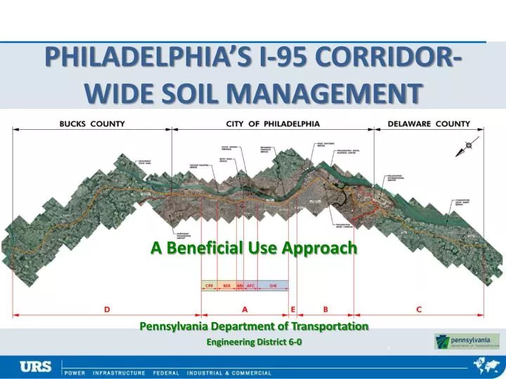
Philadelphia’s I-95 Corridor-wide Soil Management A Beneficial Use Approach Pennsylvania Department of Transportation Engineering District 6-0
Problem Statement Comply with PA’s Management of Fill Policy Maximize Beneficial Reuse/Soil Balance Minimize Soil-Handling Related Change Orders and Costs Facilitate Health & Safety Planning
Construction phases • Cottman/Princeton Interchange (CPR) • 1.4 miles • 2 Construction Phases 2009- 3/2020 • Girard Avenue Interchange (GIR) • Ramps, Interchanges, Surface Streets, Trolly • 3 miles, 6 Construction Phases 2009-9/20 • Archeological, Stormwater, Lighting
Construction phases • Betsy Ross Bridge-Girard Ave. (AFC) • Highway and Bridges; 1.5 miles; 2 Phases 2016-2025 • Betsy Ross Bridge Interchange (BRI) • Bridge/Surface Street Interchange, .8 mile, 3 Phases 2014-2020 • Levick Street to Bridge Street (BSR) • Bridge & Interchange, 2.1 miles; 3 Phases 2016-2023
problems AND RESOLUTION • Environmental Due Diligence…Eyes of the Beholder? • Publication 281 • Management of Fill • Receiving Parties
Other Considerations Entire Philadelphia Corridor is “Project Site” Underlying Fill Impacted by Historic Operations Consistent Due Diligence Post-Construction Open Space
Soil management • Considered One-Project Site • Facilitates Onsite Reuse • Consolidated Chemical Data in GIS Database • Statistical Interpretations Between Locations • Color-coded to Soil ‘Standards’ • Tracks Beneficial Reuse • Post-Construction Open Space
Database Design Elements • Consolidate Environmental Data • Multiple Design Sections • Intuitive – Ease of Use • Accessibility – Web-based • Dynamic • Data Input is Ongoing through 2023
GIS Database Features I-95 Soil Management • Internet accessible • Unique Login by User/Entity • Graphic Presentation of: • Clean/Regulated Fill • Thickness of Fill • Existing/Finish Grade • Beneficial Reuse • “Borrow” Areas
What is shown Polygons are Statistical Extrapolations Pop-up Summary
GIS Database Features • Data Queries • Hits Above ‘Standards’ • Geographic-basis • Export in Excel
Take-away • This is a Resource • Facilitates: • Agency Review /Acceptance • Pre- and In-Construction Decisions • This is a Tool • Everyone on the ‘same page’ • Accessible and Updated with Current Data • This is NOT Mandatory or End-All
Project team Pennsylvania Dept. of Transportation URS corporation Jeffrey Obrecht, PG 610-832-6190 David Miller 610-832-6192 Mike Shadle, Rob Miller • John Clarke, PG 717-787-3085 • Elaine Elbich, PE 610-205-6846 • Charles Davies, Mark Radatti, Bob Eppley