Download
1 / 50
500 likes | 642 Views
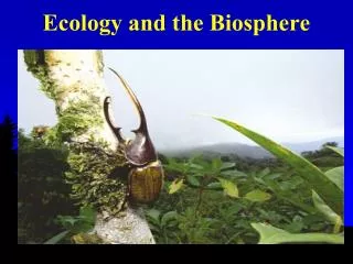
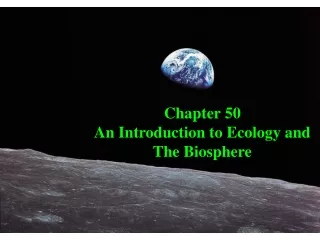
Ecology and the Biosphere. Chapter 52. Earth from the moon. Ecology . Ecology is the study of Distribution and Abundance of organisms over time. Distribution is where we naturally find / found an organism Abundance is how many individuals are / were counted at the study sites.

E N D
Ecology and the Biosphere Chapter 52
Ecology • Ecology is the study of Distribution and Abundance of organisms over time. • Distribution is where we naturally find / found an organism • Abundance is how many individuals are / were counted at the study sites
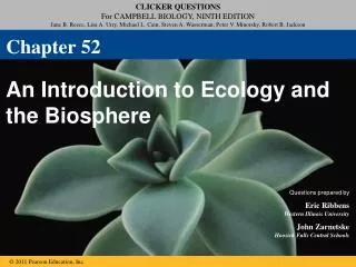
Organismal ecology Fig. 52-2 Population ecology Community ecology Ecosystem ecology Landscape ecology Global ecology
Ecological levels • Populations include all the members of one species in a given area and time. • Species include all of the potentially interbreeding populations. • Community includes all of the different species (plants, animals, fungi, etc.) living in the area • Ecosystem includes the Biotic and Physical components of the environment • Landscape- Interactions between connected ecosystems • Biosphere is world –wide issues, like Global warming, and pollution
Climate • Determines what plants can grow there • Two major factors of climate: • Temperature (warm to cold) • Precipitation (moisture – wet to dry) • Position on globe determines climate
Temperature • Simple gradient from warm to cold by increasing latitude • Solar intensity greatest and warmer at equator (0o) • Less intense and cooler at poles (90o).
Solar radiation around the Globe Solar radiation around the Globe
Precipitation • Alternating bands of wet and dry areas along a latitudinal gradient • Wet at equator 00, and 600 N / S • Dry at 300, and 900 poles • Poles are frozen deserts • Caused by formation of Hadley Cells
Hadley Cells • Air rises (00, 600) due to warming of surface. • as the air rises it becomes less dense and cooler, dropping water as rain. • Air falls (300, 900 poles) • air becomes compressed, and heats. It absorbs moisture and falls as dry air.
Global air circulation, precipitation, and winds: Hadley cells
Convection Currents • Global air circulation is affected by the properties of air water, and land. Figure 5-5
Global Air Circulation Hadley cell
West Coast Latitudes • Dry : nearer 300 • San Diego=32.5; LA= 34; Sta. Barbara= 34.5 • Santa Cruz =37, SF 37.75; • Eureka= 40.75 • Wetter nearing 600: • Portland= 45.5; Seattle= 47.5 • Juneau= 58; Anchorage = 61
Coriolis Effect • Global air circulation is affected by the rotation of the earth on its axis. Figure 5-4
Prevailing winds • These Hadley cell wind currents move North or South • The spinning of the earth makes it seem like they come at an angle. • In CA our winds, storms usually come from the south west. • Our Rains often bring warmer weather
Ocean currents • Prevailing winds cause ocean waters to move in the prevailing direction. • Northern Pacific flows clockwise • Sea level 4 feet higher in Asia • Water flows from Alaska southwards along our coast • Near shore upwelling brings cold, nutrient rich water up along our shore • Very high productivity of tidal areas
Upwelling Wind from the north starts surface ocean water moving c. Deep, cold water moves up to replace water moving west Earth's rotational force deflects moving water westward
Seasons • Caused by tilting of earth on its rotational axis. • Intensity of sunlight varies. • Most extreme at poles • Little change at equator.
Seasons- • Tilting of earth moves solar equator. • Effectively moves solar 300 dry zone north in summer • The wet belt moves farther south giving us wet winters
Biomes • Major vegetation types that also determine the animal community present. • Determined mostly by climate • Soil also important factor
Common California Biomes Dry to Wet • Desert - driest • Chaparral – shrubs with fire cycle • Grasslands – no trees, all grass • Savanna – widely spaced trees in grass • Woodland – open canopy • Forest – closed canopy, wettest
A climograph for some major kinds of ecosystems (biomes) in North America
Coniferous forest, Lady Bird Grove (top left), Sequoias (right), rain forest (bottom left)
Temperate deciduous forest, Great Smokey Mountains National Park
Desert. Organ Pipe State Park (top), Joshua Tree National Park (bottom left), Death Valley (bottom right)
Rain shadow • Precipitation increases as storms are pushed up over mountains. • accordingly rain becomes snow • As air moves up slope in the Sierras it cools 3-5 degrees per 1,000 ft. • This is the same effect as moving 300 miles farther north ! • Causes deserts in Nevada • Most islands with mountains have wet and dry sides
Summer Fog • Inland air warms quickly. This rising air, pulls in coastal air. • Marine air is pulled inland by this draw in the Central valley – causing summer winds over the low passes (Altamont) • Cold water off CA. coast cools incoming warm, moist ocean air- causing condensation. • Essential for ranges of Coast Redwoods, relic pines and cypress species . • Can add up to 10 inches of summer precipitation in some areas.
FOG HEAVEN / The sun will come out tomorrow. Or maybe not. It's summer in the city, and that means gray skies.What causes fog. Chronicle Graphic
Central Valley Smog : weblog.rudayday.com/archives/2005_08.html
Temperature Inversion layers • dense air flows downhill and collects in low spots, valleys. Great Central valley is an example. • This dense air may be blocked by hills etc. from warmer winds which blow over the top of dense air, leaving it alone. • Dense tule fog may form for days. • Inversion layer (cold air higher up) also traps pollutants. • Mexico City problems • Reno, Tahoe now ban fireplaces. • Often “burn off” in summer but leave the haze of phytochemical smog behind.
Ocean Zones • Intertidal – species rich zone on rocks between high and low tides levels. • Photic – upper sunlit layers where phytoplankton (producers) live • Neritic – productive zone over Continental Shelf • Oceanic - Open Ocean, nutrient poor low productivity