Download
1 / 6
110 likes | 476 Views
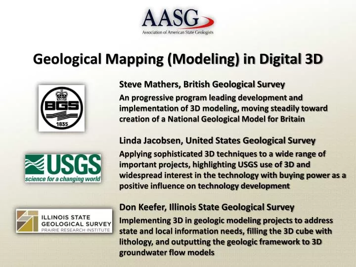
Geological Mapping (Modeling) in Digital 3D. Steve Mathers, British Geological Survey An progressive program leading development and implementation of 3D modeling, moving steadily toward creation of a National Geological Model for Britain Linda Jacobsen, United States Geological Survey

E N D
Geological Mapping (Modeling) in Digital 3D Steve Mathers, British Geological Survey An progressive program leading development and implementation of 3D modeling, moving steadily toward creation of a National Geological Model for Britain Linda Jacobsen, United States Geological Survey Applying sophisticated 3D techniques to a wide range of important projects, highlighting USGS use of 3D and widespread interest in the technology with buying power as a positive influence on technology development Don Keefer, Illinois State Geological Survey Implementing 3D in geologic modeling projects to address state and local information needs, filling the 3D cube with lithology, and outputting the geologic framework to 3D groundwater flow models
What is 3-D “Geological Modeling”? An emerging adaptable approach that: • Represents subsurface geology in x-y-z volumes of digital space • Models geologic, structural, stratigraphic, and lithologic frameworks • Thrives on large high-quality subsurface data sets and $$$$$ or £ ££ £ • Can maintain and make accessible large geoscience knowledge bases • Combines multiple data sets (e.g. lidar/imagery/surficial mapping/seismic/drilling/aeromag/resistivity/cross sections) • Makes best use of all available data • Is updatable as new data and insights are obtained • Yields highly informative products where boundaries/contacts are represented as continuous surfaces and an entire volume is modeled
We addressed: How / Where / Who? • How are 3D models created? • We reviewed software, input data, analyses, processes, costs • How are 3D models used? • Capture, display, visualization, and analysis of subsurface geology • Output of derivative views and maps for applied purposes • 3D volumes as out/input to simulations, e.g. groundwater flow • Where are 3D models needed? • Where there is strong need for subsurface information • Everywhere in Britain! • Where can they be created? • Where funds, data, and time are adequate and 3D geology is knowable • Who is creating 3D models? • Many geological survey organizations worldwide; See ISGS Circ. 578
United Kingdom Texas Illinois Canada Australia Australia Canada France Germany Netherlands United Kingdom United States Bangladesh Netherlands France California Oklahoma
Why are these organizations modeling in 3D? • To produce comprehensive models of subsurface geology, • To capture more of the available geologic knowledge and related data, • To create a digital subsurface that can be updated continually, • To provide intuitive visualizations useful for non-scientists and scientists alike, • To support comprehensive analysis and interpretation, • To help address important societal issues requiring subsurface geology, • To facilitate creation of custom derivative products to support decision making, • To allows output of geo-frameworks for 3D simulations, e.g. groundwater flow • And, because “Geological Surveys are natural custodians of the subsurface.”
Geological Mapping (Modeling) in Digital 3D Thanks to Steve, Linda, and Don!