Download
1 / 16
160 likes | 296 Views
CUAHSI Hydrologic Information System and its role in Hydrologic Observatories. Core Team: D. Maidment, J. Helly, P. Kumar, M. Piasecki, R. Hooper Collaborators: W. Graham, V. Lakshmi, X. Liang, Y. Liang, U. Lall, L. Poff, K. Reckhow, D. Tarboton, I. Zaslavsky, C. Zheng .

E N D
CUAHSI Hydrologic Information System and its role in Hydrologic Observatories Core Team: D. Maidment, J. Helly, P. Kumar, M. Piasecki, R. Hooper Collaborators: W. Graham, V. Lakshmi, X. Liang, Y. Liang, U. Lall, L. Poff, K. Reckhow, D. Tarboton, I. Zaslavsky, C. Zheng Thanks to: CUAHSI Hydrologic Information System Standing Committee
CUAHSI Hydrologic Information System (HIS) Project • This a 2-year project to develop an RFP for the Center for Hydrologic Information (CHI) and perform preliminary research and prototyping for HIS • For years 3 and onwards, all funding will be competitively awarded by NSF/CUAHSI • Center for Hydrologic Information • HydroInformatics Thematic Centers • Proposal has been recommended for funding but is awaiting final administrative approval at NSF
Environmental Cyberinfrastructure • Part of NSF Cyberinfrastructure program • Special emphasis on environmental sciences fostered by Margaret Leinen • CUAHSI Hydrologic Information Systems is one of several pilot projects
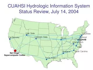
Hydrologic Information Partners Institutions of participants in the CUAHSI HIS Proposal
Hydrologic Information System Analysis, Modeling, Hypothesis testing Hydrologic Database
E P Qs D Ss Qg D Sg Ig HIS will facilitate Model Integration Watershed Models Coupled Ocean-Atmosphere Models Mesoscale Models Groundwater Models SVATs
CUAHSI Hydrologic Information System Experiments Monitoring 1. Assemble data from many sources Information Sources Remote sensing GIS Climate models 2. Integrate data into a coherent structure Hydrologic Information Data Model Hypothesis testing Analysis and Visualization 3. Do science Statistics Data Assimilation Simulation
Digital Watershed:An implementation of the CUAHSI Hydrologic Information Data Model for a particular region Created first for the Neuse basin and then for each of the following CUAHSI Observatory Planning basins
Neuse River Basin Data Themes STATSGO - General soil survey data Land Use / Land Cover Data Stream flow gages Dams Watersheds Digital Elevation Model plus lots of time series of water resources monitoring data….. Data from the Center for the Analysis & Prediction of River Basin Environmental System @ Duke University http://www.env.duke.edu/cares/
Hydrologic Characterizationat Observatories • Three properties: • Residence time distribution within “stores” • Fluxes across interfaces/stores • Flowpaths between stores • Conceptual model • Include atmosphere as part of model • Elaboration of stores (boxes) and structure must be reconciled among disciplines Need for spatial definition of “stores”, perhaps as control volumes
3D Control Volume of Neuse Basin Fluxes Extrude watershed boundary 15 km up into atmosphere and 1 km down into subsurface
Observatory Goal: Hydrologic Fluxes • Improve predictive understanding of fluxes of • Water • Sediment • Nutrients • [Selected Contaminants] • Across spatial scales, including catchment outlet • Riverine fluxes, at a minimum, but also fluxes across other interfaces (PI-specified) Need for definition of “HydroElements”, at any location in hydrologic system
Riverine HydroElements Detailed bathymetry points of a river channel 3D HydroElement formed from cross-sections and profile lines
Geospatial HydroElements Triangulated irregular network Watershed Grid 3-D Move smoothly among different views of basin
CUAHSI HIS… Parting Thoughts • We want to be as open and collaborative as possible • We welcome any ideas and suggestions you may have • We are open to helping with additional proposals to other funding sources to leverage the CUAHSI HIS effort • Email me at maidment@mail.utexas.edu