Download
1 / 1
10 likes | 125 Views
The Influence of Land Cover Dynamics on CO 2 Flux: A Case Study in São José Dos Campos, Brazil Gabriel Paiva. Methods Overlay Techniques Union between Vegetation Map + Land Use 1994 Union between Vegetation Map + Land Use 2002 Intersection between the two unions

E N D
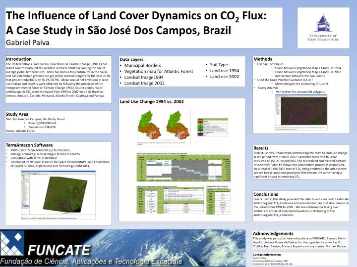
The Influence of Land Cover Dynamics on CO2 Flux: A Case Study in São José Dos Campos, Brazil Gabriel Paiva • Methods • Overlay Techniques • Union between Vegetation Map + Land Use 1994 • Union between Vegetation Map + Land Use 2002 • Intersection between the two unions • Used the Good Practice Guidance LULUCF • Methodologies for estimating CO2 stock • Query Analysis • Verification for unmatched polygons Introduction The United Nations Framework Convention on Climate Change (UNFCC) has rallied countries around the world to increase efforts in limiting the rise of average global temperatures. Brazil has been a top contributor in the cause, and has established greenhouse gas (GHG) emission targets for the year 2020 that project reductions by 36.1%-38.9%. Mean annual net emissions in land use change and forestry were obtained by following the principles of the Intergovernmental Panel on Climate Change (IPCC). Sources and sinks of anthropogenic CO2 were estimated from 1994 to 2002 for all six Brazilian biomes: Amazon, Cerrado, Pantanal, Atlantic Forest, Caatinga and Pampa. • Data Layers • Municipal Borders • Vegetation map for Atlantic Forest • Landsat Image1994 • Landsat Image 2002 • Soil Type • Land use 1994 • Land use 2002 Land Use Change 1994 vs. 2002 • Study Area • Site: São José dos Campos, São Paulo, Brazil. • Area: 1,099,600 km2 • Population: 636,876 • Biome: Atlantic Forest • TerraAmazon Software • Multi-user GIS environment (up to 20 users) • Manages remotely sensed images of Brazil’s Forests • Compatible with TerraLib database • Developed by National Institute for Space Research(INPE) and Foundation of Spatial Science, Applications and Technology (FUNCATE). Results Table #1 shows urbanization contributing the most to land use change in the period from 1994 to 2002. Land that converted to urban consisted of 156.21 ha and 88.67 ha of cropland and planted pasture respectively. Table #3 shows this urbanization process is responsible for a total of 1494.8435 tons of CO2 being emitted to the atmosphere. We see forest lands and grasslands that remain the same having a significant impact in removing CO2 Conclusions Layers used in this study provided the data sources needed to estimate anthropogenic CO2 emissions and removals for São José dos Campos in the period from 1994 to 2002. We see urbanization taking over portions of cropland and planted pasture contributing to the anthropogenic CO2 emissions. Acknowledgements This study was part of an internship done at FUNCATE. I would like to thank UbirajaraMoura de Freitas for the opportunity as well as Dr. ClotildeFerri Santos, Adriana Siqueira and my mentor Michael Palace. Contact Information Gabriel Paiva Environmental Science Major, UNH Contact me at grk74@wildcats.unh.edu