Download
1 / 4
40 likes | 152 Views
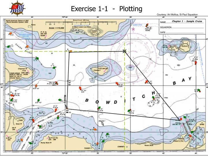
05’. 05’. 72 o 00’. 72 o 00’. 55’. 55’. 50’. 50’. 45’. 45’. 40’. 40’. N a u t I c a l M I l e s. Chapter 1 – Sample Cruise. North American Datum of 1983. (World Geodetic System 1984). Ruins. Cable Area. SOUNDINGS IN FEET. At Mean Lower Low Water. RG ”D”. Scale: 1:115,000.

E N D
05’ 05’ 72o 00’ 72o 00’ 55’ 55’ 50’ 50’ 45’ 45’ 40’ 40’ N a u t I c a l M I l e s Chapter 1 – Sample Cruise North American Datum of 1983 (World Geodetic System 1984) Ruins Cable Area SOUNDINGS IN FEET At Mean Lower Low Water RG ”D” Scale: 1:115,000 Fl(2+1)R” GONG TOWER Fl R 6s Mud R Lt 40ft 10M SECURITY ZONE HORN 165.1155 note A) (see 45’ 45’ Cl stk Fl 8s Duttons I 42ft 8M R N “2” St COL REG DEMARCATION LINE R “4” G Fl R 6s C “3” BELL G Sh C “1’ Foul ! ! ! ! ! ! ! ! ! Fl 8s 20ft 5M Chapman Pt Channel I Fl 6s 126ft 18M FIXED BRIGE hrd HORN HOR CL 1800 FT Wd VERT CL 135 FT SD (Center Span) R “6” RG “CP” Fl R 4s Fl (2+1) R 6s 41o 40’ 41o 40’ R “8” BELL I Q R R N “14” R ”10” G “3” Q R Q R R “16” G “3” Fl R 4s Fl G 4s G Kelp GONG G “15” G C “11” Fl G 4s G C “13” R “2” Fl R 4s G “9” RW OR Fl G 4s G “7” Mo (A) Rks RANGE Fl G 4s G “1” Fl G 2s G R “4” C “1” RIVER R Q R Fl G 6s TANK N “2” rky RW “BC” OYSTER 24ft 5M “3” Rks Fl R 6s Swan Pt 24ft 5M “4” Bkw SPIRE G “3” Q R R Qk Fl R BELL Lts in line 245o 20ft N “2” 22FT 2002 G 35’ 35’ C “7” G R C r e e k N ”6” C “1” G Perkins Cove Gp Fl (2) 10s E Int 6s RIVER C “3” TOWER R 23ft 10M 40ft (Aband Lt Ho) N “6” G R Rocky Neck Pt Bl a c k f I s h C “5” N “4” Haven Bluff OYSTER CHIMNEY TOWER Exercise 1-1 - Plotting Courtesy: Art Mollica, St Paul Squadron D 6.1 C 017M
05’ 05’ 72o 00’ 72o 00’ 55’ 55’ 50’ 50’ 45’ 45’ 40’ 40’ N a u t I c a l M I l e s Chapter 1 – Sample Cruise North American Datum of 1983 (World Geodetic System 1984) Ruins Cable Area SOUNDINGS IN FEET At Mean Lower Low Water RG ”D” Scale: 1:115,000 Fl(2+1)R” GONG TOWER Fl R 6s Mud R Lt 40ft 10M SECURITY ZONE HORN 165.1155 note A) (see 45’ 45’ Cl stk Fl 8s Duttons I 42ft 8M R N “2” St COL REG DEMARCATION LINE R “4” G Fl R 6s C “3” BELL G Sh C “1’ Foul ! ! ! ! ! ! ! ! ! Fl 8s 20ft 5M Chapman Pt Channel I Fl 6s 126ft 18M FIXED BRIGE hrd HORN HOR CL 1800 FT Wd VERT CL 135 FT SD (Center Span) R “6” RG “CP” Fl R 4s Fl (2+1) R 6s 41o 40’ 41o 40’ R “8” BELL I Q R R N “14” R ”10” G “3” Q R Q R R “16” G “3” Fl R 4s Fl G 4s G Kelp GONG G “15” G C “11” Fl G 4s G C “13” R “2” Fl R 4s G “9” RW OR Fl G 4s G “7” Mo (A) Rks RANGE Fl G 4s G “1” Fl G 2s G R “4” C “1” RIVER R Q R Fl G 6s TANK N “2” rky RW “BC” OYSTER 24ft 5M “3” Rks Fl R 6s Swan Pt 24ft 5M “4” Bkw SPIRE G “3” Q R R Qk Fl R BELL Lts in line 245o 20ft N “2” 22FT 2002 G 35’ 35’ C “7” G R C r e e k N ”6” C “1” G Perkins Cove Gp Fl (2) 10s E Int 6s RIVER C “3” TOWER R 23ft 10M 40ft (Aband Lt Ho) N “6” G R Rocky Neck Pt Bl a c k f I s h C “5” N “4” Haven Bluff OYSTER CHIMNEY TOWER Exercise 1-1 - Plotting & Labeling C 104M D 6.3 C 155M D 9.8 D 6.1 C 017M D 12.9 C 290M
05’ 05’ 72o 00’ 72o 00’ 55’ 55’ 50’ 50’ 45’ 45’ 40’ 40’ N a u t I c a l M I l e s Chapter 1 – Sample Cruise North American Datum of 1983 (World Geodetic System 1984) Ruins Cable Area SOUNDINGS IN FEET At Mean Lower Low Water RG ”D” Scale: 1:115,000 Fl(2+1)R” GONG TOWER Fl R 6s Mud R Lt 40ft 10M SECURITY ZONE HORN 165.1155 note A) (see 45’ 45’ Cl stk Fl 8s Duttons I 42ft 8M R N “2” St COL REG DEMARCATION LINE R “4” G Fl R 6s C “3” BELL G Sh C “1’ Foul ! ! ! ! ! ! ! ! ! Fl 8s 20ft 5M Chapman Pt Channel I Fl 6s 126ft 18M FIXED BRIGE hrd HORN HOR CL 1800 FT Wd VERT CL 135 FT SD (Center Span) R “6” RG “CP” Fl R 4s Fl (2+1) R 6s 41o 40’ 41o 40’ R “8” BELL I Q R R N “14” R ”10” G “3” Q R Q R R “16” G “3” Fl R 4s Fl G 4s G Kelp GONG G “15” G C “11” Fl G 4s G C “13” R “2” Fl R 4s G “9” RW OR Fl G 4s G “7” Mo (A) Rks RANGE Fl G 4s G “1” Fl G 2s G R “4” C “1” RIVER R Q R Fl G 6s TANK N “2” rky RW “BC” OYSTER 24ft 5M “3” Rks Fl R 6s Swan Pt 24ft 5M “4” Bkw SPIRE G “3” Q R R Qk Fl R BELL Lts in line 245o 20ft N “2” 22FT 2002 RR 1/2NM N – UP HDG 096 M EBL1 084 R EBL2 180 R VRM1 1.4 NM G 35’ 35’ C “7” G R C r e e k N ”6” C “1” G Perkins Cove Gp Fl (2) 10s E Int 6s RIVER C “3” TOWER R 23ft 10M 40ft (Aband Lt Ho) N “6” G R Rocky Neck Pt Bl a c k f I s h C “5” N “4” Haven Bluff OYSTER CHIMNEY TOWER Exercise 1-1 - Navigation Scenario B D 6.1 C A C 017M E F D
05’ 05’ 72o 00’ 72o 00’ 55’ 55’ 50’ 50’ 45’ 45’ 40’ 40’ N a u t I c a l M I l e s Chapter 1 – Sample Cruise North American Datum of 1983 (World Geodetic System 1984) Ruins Cable Area SOUNDINGS IN FEET At Mean Lower Low Water RG ”D” Scale: 1:115,000 Fl(2+1)R” GONG TOWER Fl R 6s Mud R Lt 40ft 10M SECURITY ZONE HORN 165.1155 note A) (see 45’ 45’ Cl stk Fl 8s Duttons I 42ft 8M R N “2” St COL REG DEMARCATION LINE R “4” G Fl R 6s C “3” BELL G Sh C “1’ Foul ! ! ! ! ! ! ! ! ! Fl 8s 20ft 5M Chapman Pt Channel I Fl 6s 126ft 18M FIXED BRIGE hrd HORN HOR CL 1800 FT Wd VERT CL 135 FT SD (Center Span) R “6” RG “CP” Fl R 4s Fl (2+1) R 6s 41o 40’ 41o 40’ R “8” BELL I Q R R N “14” R ”10” G “3” Q R Q R R “16” G “3” Fl R 4s Fl G 4s G Kelp GONG G “15” G C “11” Fl G 4s G C “13” R “2” Fl R 4s G “9” RW OR Fl G 4s G “7” Mo (A) Rks RANGE Fl G 4s G “1” Fl G 2s G R “4” C “1” RIVER R Q R Fl G 6s TANK N “2” rky RW “BC” OYSTER 24ft 5M “3” Rks Fl R 6s Swan Pt 24ft 5M “4” Bkw SPIRE G “3” Q R R Qk Fl R BELL Lts in line 245o 20ft N “2” 22FT 2002 G 35’ 35’ C “7” G R C r e e k N ”6” C “1” G Perkins Cove Gp Fl (2) 10s E Int 6s RIVER C “3” TOWER R 23ft 10M 40ft (Aband Lt Ho) N “6” G R Rocky Neck Pt Bl a c k f I s h C “5” N “4” Haven Bluff OYSTER CHIMNEY TOWER Exercise 1-1 - Plotting & Labeling BB01 C 104M 1103 1031 D 6.3 S 12 C 155M S 12 D 9.8 D 6.1 1010 C 017M S 12 1000 C 287M 1215 GPS 1258 D 8.6 S 12 1152 C 290M 1215 S 12