Download
1 / 15
150 likes | 316 Views
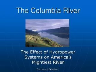
Columbia River Sediment Supply and Dredging Volumes. David A. Jay Department of Environmental Science and Engineering, Oregon Graduate Institute. Critical Points --. Columbia River flow varies with the Pacific Decadal Oscillation (PDO) cycle

E N D
Columbia River Sediment Supply and Dredging Volumes David A. Jay Department of Environmental Science and Engineering, Oregon Graduate Institute
Critical Points -- • Columbia River flow varies with the Pacific Decadal Oscillation (PDO) cycle • Climate-related fluctuations in sand input are larger than those in flow • Most sand transport occurs as suspended load during freshets • Dredging volumes are correlated with flow and sand supply • We are trying to understand a data-poor system
Important Time Scales -- • In inferring changes, it is important to average over an appropriate period: • for climate, at least one full PDO cycle • for human processes, over the “present” management regime • One+ full PDO cycles has occurred since ~1946 • Period since 1970 is the hydrologic “present”, in terms of CR flow regulation. WR is less regulated • 40-ft channel was finished in the mid-1970s • 25-30 years is a short time for estimating effects of climate cycles
PDO and Columbia R. Flow, 1858-2000-- • CR flow exhibits large variability over 20-50 years • Cold-PDO years since 1946 include very high flows • Low-flow, warm PDO periods like 1977-95 have occurred for only ~40-45 years since 1890 • The 1980-95 period is not typical of the last 140 years Unknown PDO Cold PDO Warm PDO Cold PDO Warm PDO ColdPDO
PDO and Columbia R. Flow, 1946-2000: • Cold PDO: 1946-76, mean Beaver flow 7,325 m3s-1 1996-00, mean Beaver flow 8,090 m3s-1 • Warm PDO: 1977-95: mean Beaver flow 6,210 m3s-1 • Cold/Warm PDO differ by a 20+% • Ten years during 1980-95 are in the lowest third of all flow years since 1878 ColdPDO Cold PDO Warm PDO
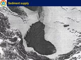
Sediment Transport Hindcasts -- • Sediment transport has been hindcast to 1858 using flow records and USGS data -- • sand transport is usually transport-capacity limited • fine sediment transport is supply limited • Excludes Mt. St Helens effects, 1980-81 • Our approach is generally conservative -- • supply from winter freshets is underestimated • USGS probably underestimated sand transport • Haven’t included tributaries below the Willamette River • But -- • overbank flows may transport less sediment (affects pre-1956) • cannot account for changes in land use
Sediment Transport Amplifies Climate Effects: • Sediment transport varies with flow QR as QRn, n>1 • For total load, n ~ 2.5; for sand, n ~ 3.5 • There are changes in SPM quality (poorly understood) • This amplification is an important aspect of how modest climate changes have large ecosystem effects, e.g., on salmonids
Sand Transport, 1946-99 • Cold PDO: 1946-76, CR+WR 4.5 x10⁶ mt tons yr-1 1970-76, 1996-99, CR+WR 3.3 x10⁶ mt tons yr-1 • Warm PDO: 1977-95: CR+WR ~1 x10⁶ mt tons yr-1* • Warm/cold PDO sand transports differ by factor of 3-4 *1980 and 1981 exclude Mt. St. Helens sand input Cold PDO Warm PDO ColdPDO Cold PDO Warm PDO
Sand Transport Mechanisms-- • Most bed-material (sand) transport occurs in suspension, during high-flow events • For flows greater than 15,000 m3s-1, 70-90% of the total load is sand, mostly in suspension • Bedload transport is dominant in low-flow years, needs to be considered in all years • 30-yr study in Fraser River suggest that ~7.5% of sand transport is bedload. 13% of total bed material transport is as bedload (including gravel)
Dredging Volumes -- • Seven high-flow years since 1976: 12.2 2.3 x10⁶ mt tons yr-1(95% conf limits) • Sixteen low-flow years since 1976: 7.4 1.2 x10⁶ mt tons yr-1(95% conf limits) • Ratio for highflow years to lowflow years is 1.65 • EIS Projected dredging is 6.3 x10⁶ mt tons yr-1 Cold PDO Cold PDO Warm PDO
Dredging and Hydrology: • Dredging is correlated with flow, R2 ~0.3- 0.5 (depending on the model used) and with sand transport, R2 ~0.3- 0.6 • Best results obtained when current year of dredging is compared to the past two years of flow or sand transport • There appears to be a base dredging level of ~2-3 x 10⁶ yd3
Dredging Impacts on Accretion -- • Average dredging: 1975-99 ~8.9 x10⁶ mt tons yr-11946-99 ~10.4 x10⁶ mt tons yr-1( Not all of this is removed from system) • Sand supply: 1975-99 ~2.5 x10⁶ mt tons yr-11946-99 ~4.6 x10⁶ mt tons yr-1There was long-term accumulation of sand, 1868-1958 • Above imbalance raises a question regarding effect of sand removal on habitat • Has the long-term trend toward accumulation reversed? (The data are not available to answer this question)
Conclusions -- • Dredging estimates based on 1982-95 understate likely volumes -- • disposal impacts will likely also exceed projections. • What if I am wrong, and dredging volumes are correct? -- • long-term mining of sand from the channel through land disposal is still a major impact on fluvial and estuarine habitats
Recommendations -- • A range of dredging volume estimates need to be based on multiple climate scenarios • Project impacts on salmonids need to be determined in relation to other impacts -- e.g., diking, loss of peripheral wetlands and flow regulation • Systematic monitoring and research regarding sediment processes are needed
Necessary monitoring and research: • Map habitat changes and analyze w.r.t. to changes in sediment supply • Long-term monitoring of suspended and bed load • Understand effects of land-use on supply/export and accumulation of coarse and fine sediment • Understand quality and quantity of POC input in relation to freshet styles • Model sediment as a system-critical resource