Download
1 / 23
230 likes | 330 Views
Objectives. Build a stream network for the 12th hydrologic region, based on NHD datasets.Create a step by step guide.. ArcInfo 8x. Same components ArcMapArcCatalogArcToolsMore powerful than ArcView. Geodatabase. Relational databases that contain geographic informationOrganize the data

E N D
1. Building a stream network for the 12th Hydrologic region using ArcInfo CVEN 689
Prepared by:
H�ctor Olmos
2. Objectives Build a stream network for the 12th hydrologic region, based on NHD datasets.
Create a step by step guide.
3. ArcInfo 8x Same components
ArcMap
ArcCatalog
ArcTools
More powerful than ArcView
Build geometric networks
Project grids
Build geometric networks
Project grids
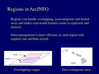
4. Geodatabase Relational databases that contain geographic information
Organize the data
Create the geometric network
Geodatabases are relational databases that contain geographic information.
Geodatabases contain feature classes, feature datasets relationships and tables
The main characteristic of a feature dataset is that they have a unique spatial reference and all the feature classes inside of it share the same spatial reference
Feature classes store geographic features represented as points, lines, or polygons
Stand alone tables can also be included in the personal geodatabase or in a feature datasetGeodatabases are relational databases that contain geographic information.
Geodatabases contain feature classes, feature datasets relationships and tables
The main characteristic of a feature dataset is that they have a unique spatial reference and all the feature classes inside of it share the same spatial reference
Feature classes store geographic features represented as points, lines, or polygons
Stand alone tables can also be included in the personal geodatabase or in a feature dataset
5. Network Set of edges and junctions that are topologically connected to each other. Know what is upstream, downstream, which junction is at the beginning and at the end of an edge.
Streets network
Stream network
Pipes network
Electric network
In ArcInfo a network is defined as a geometric network
Know what is upstream, downstream, which junction is at the beginning and at the end of an edge.
Streets network
Stream network
Pipes network
Electric network
In ArcInfo a network is defined as a geometric network
6. Geometric Network One dimensional nonplanar graph
Network connectivity is based on geometric coincidence name
Logical network = virtual representation
Defines rules of behavior
One dimensional nonplanar graph where Features are constrained to exist within the network
Network connectivity is based on geometric coincidence�� name
Logical network is a virtual representation of the geometric network
Defines rules of behavior such as what classes of edges can connect to a particular class of junction
A 10in pipe cannot connect to a 8 in pipe without a special kind of joint.One dimensional nonplanar graph where Features are constrained to exist within the network
Network connectivity is based on geometric coincidence�� name
Logical network is a virtual representation of the geometric network
Defines rules of behavior such as what classes of edges can connect to a particular class of junction
A 10in pipe cannot connect to a 8 in pipe without a special kind of joint.
7. Study Region Hydrologic Regions My study zone is the 12th hydrologic region of the U.S, Texas-Gulf, that contains all the streams and rivers that drains towards the gulf of Mexico.
My study zone is the 12th hydrologic region of the U.S, Texas-Gulf, that contains all the streams and rivers that drains towards the gulf of Mexico.
8. Region 12 Texas-Gulf 11 subregions
22 accounting units
122 Cataloging Units 11 subregions
22 accounting units
122 Cataloging Units
It contains the brazos river basin, very important for texas.11 subregions
22 accounting units
122 Cataloging Units
It contains the brazos river basin, very important for texas.
9. NHD National Hydrography Dataset
Contains information about surface water features
Medium resolution (1:100,000)
High resolution (1:24,000)
NHD data is a comprehensive set of digital spatial data that contains information about surface water features such as lakes, ponds, streams, rivers, springs and wells.�
Also contains channels pipelines shorelines, features that are not part of a stream network.NHD data is a comprehensive set of digital spatial data that contains information about surface water features such as lakes, ponds, streams, rivers, springs and wells.�
Also contains channels pipelines shorelines, features that are not part of a stream network.
10. Data quality comparison Rf1 (1:500,000): not at all accurate and very little detail
NHD Medium resolution (1:100,000) More accurate and more detailed Includes water bodies and centerlines that represent flow through waterbodies
NHD High resolution (1:24,000) A lot more details and accuracy, it would have been preferable to build the stream network with this resolution, not complete coverage and
database would have been very heavy.Rf1 (1:500,000): not at all accurate and very little detail
NHD Medium resolution (1:100,000) More accurate and more detailed Includes water bodies and centerlines that represent flow through waterbodies
NHD High resolution (1:24,000) A lot more details and accuracy, it would have been preferable to build the stream network with this resolution, not complete coverage and
database would have been very heavy.
11. Procedure
12. Download NHD Download & extract NHD datasets
Download CU and so on�. Region
After the download is complete, the downloaded datasets are uncompressed
Download CU and so on�. Region
After the download is complete, the downloaded datasets are uncompressed
13. Append NHD Create a single dataset
Append_NHD tool
In order to build the network it is necessary to have a single dataset, all the CU datasets were appended into a single one.
This was done using append_NHD tool, developed by NHD, this tool has to be run under ArcInfo 7.1.2 or greater.
NHD recommends, since using the geoprocessing tools may not correct some errors in the output dataset. In order to build the network it is necessary to have a single dataset, all the CU datasets were appended into a single one.
This was done using append_NHD tool, developed by NHD, this tool has to be run under ArcInfo 7.1.2 or greater.
NHD recommends, since using the geoprocessing tools may not correct some errors in the output dataset.
14. Select the streams
Streams, pipelines, channels, shorelines
�Clean� the streams
NHD datasets are very detailed and contain a lot of information, not only streams or rivers, they also include pipelines, channels, shorelines
In my project I deleted all pipelines and channels, since I considered channels not being natural streams.NHD datasets are very detailed and contain a lot of information, not only streams or rivers, they also include pipelines, channels, shorelines
In my project I deleted all pipelines and channels, since I considered channels not being natural streams.
15. Create Sinks
Flow direction
Stream network (only sinks)
In order to assign the flow direction, Sinks have to be created.
FD in a Stream network can be set only by defining the sinks
Located at the outlets.
Locate a sink wherever a stream touches the coastline.In order to assign the flow direction, Sinks have to be created.
FD in a Stream network can be set only by defining the sinks
Located at the outlets.
Locate a sink wherever a stream touches the coastline.
16. Snap gauging stations Not connected to streams
Since Features are constrained to exist within the network gauging stations must be connected to the streams.
So I snapped the gaging stations
Some stations don�t have streams, �. Resolution and are not snapped.
Since Features are constrained to exist within the network gauging stations must be connected to the streams.
So I snapped the gaging stations
Some stations don�t have streams, �. Resolution and are not snapped.
17. Create the Geometric Network Select features
Define sinks
Snapping options
Errors table Select the features that are part of the geometric network, sinks, streams as coverage and gaging stations.
Since In this case sinks are defined, it is necessary to select the feature class that contains the sinks
Since NHD datasets are snapped and the gauging stations too, it is not necessary
The errors table displays the invalid geometries.Select the features that are part of the geometric network, sinks, streams as coverage and gaging stations.
Since In this case sinks are defined, it is necessary to select the feature class that contains the sinks
Since NHD datasets are snapped and the gauging stations too, it is not necessary
The errors table displays the invalid geometries.
18. Invalid geometries Invalid features were deleted
These invalid features have to be corrected.
Most of the invalid features had a very small length, 1 or 2 meters, which I associate with errors while digitizing the streams.
I deleted these and corrected the connectivity between the streams.
Some features were isolated, these were also deleted.These invalid features have to be corrected.
Most of the invalid features had a very small length, 1 or 2 meters, which I associate with errors while digitizing the streams.
I deleted these and corrected the connectivity between the streams.
Some features were isolated, these were also deleted.
19. Loops Flow direction not defined
Delete the longest path
The next step is to correct the loops, as you can see in this picture, the upstream trace from the green point is not complete, this is due to the existence of a loop
In order to correct it, the longest flow path has to be deleted, since water flows through the steepest path, therefore the shortest one
Since water flows through the steepest path, this is also the shortest one.
Once the loop has been corrected the new trace will include the streams that were upstream from the loop.The next step is to correct the loops, as you can see in this picture, the upstream trace from the green point is not complete, this is due to the existence of a loop
In order to correct it, the longest flow path has to be deleted, since water flows through the steepest path, therefore the shortest one
Since water flows through the steepest path, this is also the shortest one.
Once the loop has been corrected the new trace will include the streams that were upstream from the loop.
20. Tracing Tracing downstream
Tracing Upstream
Once the loops and invalid geometries have been corrected, tracing operations can be done.
All tracing operations are initiated by placing a flag at the network location, from which the trace originates.
Upstream tracing identifies all edges and junctions that drain to the flag location
Downstream tracing identifies all edges and junctions that constitute the flow path from the flag location to the network outlet or sink.Once the loops and invalid geometries have been corrected, tracing operations can be done.
All tracing operations are initiated by placing a flag at the network location, from which the trace originates.
Upstream tracing identifies all edges and junctions that drain to the flag location
Downstream tracing identifies all edges and junctions that constitute the flow path from the flag location to the network outlet or sink.
21. Conclusions Preparing the data takes a lot of time (this was a huge area)
Some of the deleted features were really streams.
Building a stream network is not very difficult once the data has been filtered.
A stream network has a lot of applications.
Deleted streams: in medium resolution NHD some features were classified as channels, while in the High resolution NHD, these features were classified as streams.Deleted streams: in medium resolution NHD some features were classified as channels, while in the High resolution NHD, these features were classified as streams.
22. Future work Create a tool that automatically finds loops and corrects them.
Create a new network with high resolution NHD datasets.
23. Questions?