Download

1 / 25
250 likes | 260 Views
This project focuses on creating an interactive map for shelters in Montgomery County and analyzing incident data received by the Montgomery County Fire & Rescue Service (MCFRS). The project includes data clean-up, descriptive statistics, and the final product of the interactive map and incident analysis. Recommendations for enhancing the map and the MCFRS dataset are also provided.

E N D
Data Montgomery Experience Final report presentation Brian Perez | DATA 205 Capstone in Data Science | Wednesday, may 1st 2019
Agenda • Overview Of Project Plan • Shelters Interactive Map • MCFRS Incident Analysis • Shelters Interactive Map • Data Clean Up • Descriptive Statistics • Final Product: The map • Data Story • Recommendations • MCFRS Incident Analysis • Data Clean Up • Descriptive Statistics • Final Product: The Analysis • Data Story • Recommendations • dataMontgomery Experience • Acknowledgements
Overview of the project plan • Shelters Interactive Map • Goal 1 – Create services that allow users to interact with geographical data via a web-based interactive map • Dataset – Emergency Shelter Activation Status • Tools – HTML, JavaScript, Leaflet JS, Bing, AWS S3 (hosting), Route 53 (Domain Name Registration) • Montgomery Country Fire & Rescue Service (MCFRS) Incident Analysis • Goal 2 – Provide an analysis of 911 calls received by MCFRS to better understand the nature, frequency and locations of the calls • Dataset – MCFRS_Incidents_by_Station, Population MD, Zip Code Shape File • Tools – Python, Geopy, Nominatim, pandas, numpy, matplotlib, seaborn, statsmodels.api, datetime, Tableau
Agenda • Overview Of Project Plan • Shelters Interactive Map • MCFRS Incident Analysis • Shelters Interactive Map • Data Clean Up • Descriptive Statistics • Final Product: The map • Data Story • Recommendations • MCFRS Incident Analysis • Data Clean Up • Descriptive Statistics • Final Product: The Analysis • Data Story • Recommendations • dataMontgomery Experience • Acknowledgements
Shelters Interactive Map – Data Clean Up • Extracted shelter data (GeoJSON) via Socrata’s API function – Active Shelters Link • All shelters are listed as CLOSED • Created mock data with a few shelters listed as OPEN • Included Hospital and Police stations in the area • Source:dataMontgomery (hospitals), and GIS Open Data (police stations) • API Links changes when new data gets uploaded to dataMontgomery • Old Link (Mar-19): https://data.montgomerycountymd.gov/resource/4yqk-nikt.geojson • New Link (Apr -19): https://data.montgomerycountymd.gov/resource/mhua-idee.geojson
Agenda • Overview Of Project Plan • Shelters Interactive Map • MCFRS Incident Analysis • Shelters Interactive Map • Data Clean Up • Descriptive Statistics • Final Product: The map • Data Story • Recommendations • MCFRS Incident Analysis • Data Clean Up • Descriptive Statistics • Final Product: The Analysis • Data Story • Recommendations • dataMontgomery Experience • Acknowledgements
Shelters Interactive Map – Final product THE PRODUCT THE PROCESS http://itforaid.org/map/mcshelters.html - Test http://itforaid.org/map/mcshelterslive.html - Live
Agenda • Overview Of Project Plan • Shelters Interactive Map • MCFRS Incident Analysis • Shelters Interactive Map • Data Clean Up • Descriptive Statistics • Final Product: The map • Data Story • Recommendations • MCFRS Incident Analysis • Data Clean Up • Descriptive Statistics • Final Product: The Analysis • Data Story • Recommendations • dataMontgomery Experience • Acknowledgements
Shelters Interactive Map – Recommendations • Provide additional details for shelters • Maximum capacity permitted • Description of services offered • Point of Contact: email and number • Shelter type (e.g. school, rec. center, community center) • Set static API links when updating data in Socrata • Increase number of pet friendly shelters • Enhancements to the application: • Find nearest open shelter based on a user’s location • Integrate app. with mapping apps • Add layers such as road closures and traffic conditions • Provide additional details for Police Stations dataset on Data Montgomery
Agenda • Overview Of Project Plan • Shelters Interactive Map • MCFRS Incident Analysis • Shelters Interactive Map • Data Clean Up • Descriptive Statistics • Final Product: The map • Data Story • Recommendations • MCFRS Incident Analysis • Data Clean Up • Descriptive Statistics • Final Product: The Analysis • Data Story • Recommendations • dataMontgomery Experience • Acknowledgements
MCFRS Incident Analysis – Data Clean Up Isolate Addresses Drop Duplicates Get Lat/Long Merge Lat/Long to Incidents • Geocoding Incident Data • Reclassifying Call Types: From 99 to 5 Types ('Health', 'Structural/Environment', 'Threat/Legal', 'Service', 'UNK’) • Time Series Analysis Date Format: Add expected date formats for Time Series and Seasonal Decomposition Analysis • Tableau Analysis & Dashboard
Agenda • Overview Of Project Plan • Shelters Interactive Map • MCFRS Incident Analysis • Shelters Interactive Map • Data Clean Up • Descriptive Statistics • Final Product: The map • Data Story • Recommendations • MCFRS Incident Analysis • Data Clean Up • Descriptive Statistics • Final Product: The Analysis • Data Story • Recommendations • dataMontgomery Experience • Acknowledgements
MCFRS Incident Analysis – Descriptive Stats Barplot - Calls Received - Agg. 3/2014 - 2/2019 Barplot - Calls Received by Year - Agg. 2014 - 2019
MCFRS Incident Analysis – Descriptive Stats 2019 does not have a full year of data
MCFRS Incident Analysis – Descriptive Stats Drop due to missing data on 3/2014
MCFRS Incident Analysis – Descriptive Stats Removed March 2014
Agenda • Overview Of Project Plan • Shelters Interactive Map • MCFRS Incident Analysis • Shelters Interactive Map • Data Clean Up • Descriptive Statistics • Final Product: The map • Data Story • Recommendations • MCFRS Incident Analysis • Data Clean Up • Descriptive Statistics • Final Product: The Analysis • Data Story • Recommendations • dataMontgomery Experience • Acknowledgements
MCFRS Inc. Analysis – Seasonal decomposition Observed = Trend + Seasonal + Residual Calls increase over time, perhaps due to increase in population Spikes at the start of each year, perhaps due to the flu common during the winter Observed = Trend + Seasonal + Residual Trend = Overall change over time Seasonal = Change within a given period Residual = Random variation in the series
Agenda • Overview Of Project Plan • Shelters Interactive Map • MCFRS Incident Analysis • Shelters Interactive Map • Data Clean Up • Descriptive Statistics • Final Product: The map • Data Story • Recommendations • MCFRS Incident Analysis • Data Clean Up • Descriptive Statistics • Final Product: The Analysis • Data Story • Recommendations • dataMontgomery Experience • Acknowledgements
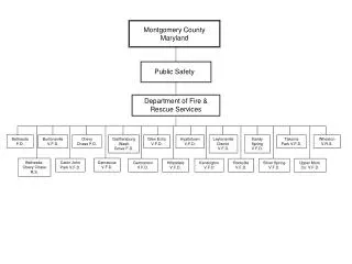
MCFRS Incident Analysis – Data Story Calls by City 2014 - 2019 73% of calls are Health related Specifically Sickness The majority of the calls occur in Silver Spring (162,500) Gaithersburg-Washington Grove Volunteer Fire Department (Station 8) has received the most calls: 49,135 Trend of Health Calls Received • Most Health calls occur during the winter months • Staff Centers Accordingly • Increase Flu Shot Availability Note: Info based on data Apr 2014 – Mar 2019
Agenda • Overview Of Project Plan • Shelters Interactive Map • MCFRS Incident Analysis • Shelters Interactive Map • Data Clean Up • Descriptive Statistics • Final Product: The map • Data Story • Recommendations • MCFRS Incident Analysis • Data Clean Up • Descriptive Statistics • Final Product: The Analysis • Data Story • Recommendations • dataMontgomery Experience • Acknowledgements
MCFRS Incident Analysis – Recommendations • Add lat/long coordinates for the Fire Stations • Add Time Stamp of Call • Validate Zip Codes and Addresses
Agenda • Overview Of Project Plan • Shelters Interactive Map • MCFRS Incident Analysis • Shelters Interactive Map • Data Clean Up • Descriptive Statistics • Final Product: The map • Data Story • Recommendations • MCFRS Incident Analysis • Data Clean Up • Descriptive Statistics • Final Product: The Analysis • Data Story • Recommendations • dataMontgomery Experience • Acknowledgements
Experiences & Acknowledgements • Pros of dataMontgomery • Open Government: Montgomery County’s commitment to increasing transparency and citizen involvement in general aspects of e-Government services • Support: Quick Response from Data Owners/Staff • Accessible: As a first time Socrata user, the tool meets its goal of making data accessible to the average non-technical user. • Cons of dataMontgomery • Navigation: Navigation can be cumbersome with a large amount of unvalidated data sets and views • Maps: Mapping functionality was limited • APIs: API links should be static if possible • Acknowledgements • Kathryn L -- Dennis L -- Kathy L -- Mayro N – Peter P – Carlos C • stackOverflow -- machinelearningmastery.com -- http://sopac-old.ucsd.edu/convertDate.shtml -- data.imap.maryland.gov