Download
1 / 26
260 likes | 283 Views
Explore the stratigraphic units and marine-fluvial correlation in the U. Cretaceous Wyoming Trout Creek area, focusing on transitions between shorelines and fluvial successions. Investigate the relationship between shorelines and updip fluvial sandstones, including forced regression and progradation processes. Key questions address shoreline progradations, transgressive-regressive shorelines, and fluvial-estuarine alternations in the Trout Creek and 20-Mile area. Discover the steep trajectory of the Iles shoreline and its reflection in fluvial architecture.

E N D
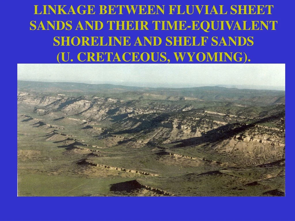
LINKAGE BETWEEN FLUVIAL SHEET SANDS AND THEIR TIME-EQUIVALENT SHORELINE AND SHELF SANDS (U. CRETACEOUS, WYOMING).
TROUT CREEK FLUVIAL-COASTAL PLAIN-SHORELINE-SHELF TRANSITS
THE STRATIGRAPHIC UNITS AND THE MARINE-FLUVIAL CORRELATION 20-Mile Trout Creek 13 9 3 3
LOOKING AT THE LINKAGE BETWEEN SHORELINES AND UPDIP, TIME-EQUIVALENT FLUVIAL SUCCESSIONS
A conceptual sidestep:Sequence stratigraphy of regressive-to-transgressive shoreline tongues Forced regression involved because of great progradational distance
Lets look at the middle reaches of linked system: the shorelines Tens of regressive-to-transgressive migrations (with up to 100 km transits) of the shorelines
ILES, TROUT CREEK & 20-MILE SHORELINES AT DISTAL END OF TRANSECT Trout Creek 20-Mile Iles Mancos Sands Mancos Shale
20-MILE TROUT CREEK ILES MODIFIED FROM MASTERS 1966
Expression at the updip reaches of the linked system • Amalgamated fluvial successions, but with clusters of unconformities and repeated brackish-water (estuarine) influence
Trail Member, Ericson Formation near Rock Springs, WY Trail Mb. 10 m Rock Springs Fm.
Expression at the regressive maximum of the linked system • Development of lowstand deltas • Change of dynamic regime to tidal domination
KEY QUESTIONS • Can the largest shoreline progradations (Iles 3, Iles 9, Trout Creek, 20-Mile) be related to recognizable unconformities in the updip region? • Are the numerous transgressive-regressive shoreline transits of the Iles (16 of them) reflected in the Ericson ‘fluvial’ succession? • Is the steep shoreline trajectory of the Iles (aggradational) reflected in the character of the Trail-Rusty members of the Ericson?
QUESTION 1: Are there by-pass, erosion surfaces in the updip fluvial succession that are equivalent to the big downdip shoreline progradation pulses? TWENTY-MILE u/c? CANYON CREEK TROUT CREEK u/c? RUSTY TRAIL ILES 9 u/c ? ILES 3 u/c? GR log
TWENTY-MILE SANDSTONE Incised valley Shoreline
QUESTION 2: ARE THE NUMEROUS REGRESSIVE-TO-TRANSGRESSIVE TRANSITS OF THE DOWNDIP SHORELINES REFLECTED IN THE UPDIP FLUVIAL SUCCESSION?
THE REGRESSIVE-TO-TRANSGRESSIVE TRANSITS OF THE DOWNDIP SHORELINES ARE EXPRESSED IN THE UPDIP AREAS BY FLUVIAL-ESTUARINE ALTERNATIONS FLUVIAL ESTUARINE
estuarine SB fluvial NUMEROUS BRACKISH-WATER INCURSIONS
IHS - inclined heterolithic strata FLUVIAL CHANNELS IIHSI on lower coastal plain/ estuary SB Skolithos • Trace Fossils: • Teichichnus • Skolithos • Planolites • Teredolites
ILES QUESTION 3: Overall shoreline trajectory for lles is steep (it contrasts with the Trout Creek and 20-Mile trajectories). Why is this trajectory steep, & can we recognize this aggradational pattern in the updip fluvial succession ?
UPDIP FLUVIAL ARCHITECTURE & UNCONFORMITIES : AGGRADATIONAL STACKING OF HIGH-FREQUENCY R/T SEQUENCES ILES 9 ? ILES 3 ?
SHELF SANDS AT THE REGRESSIVE MAXIMA: PROBABLY LOWSTAND DELTAS DEVELOPED DURING HIGH SEDIMENT SUPPLY AT THE R/T TURNAROUND
TST HST FRST LST CONCLUSIONS: 1. Basic building block for the alluvial-coastalplain-shoreline-shelf succession is shown 2. Rate changes required only at the sequence boundary (SB) and at the MFS