Download
1 / 28
280 likes | 419 Views
Integrated Modeling & Data A ccess — CUAHSI HIS HydroModeler. CUAHSI HIS Team Members:.

E N D
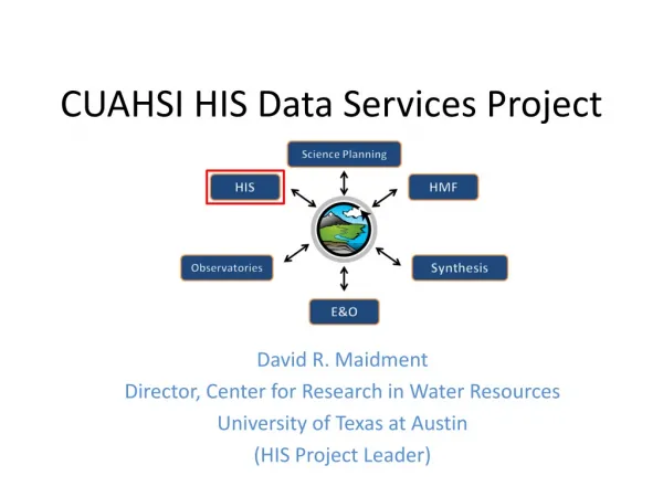
Integrated Modeling & Data Access — CUAHSI HIS HydroModeler CUAHSI HIS Team Members: David Maidment (PI), David Tarboton (co-PI), Ilya Zaslavsky (co-PI), Dan Ames (co-PI), Jon Goodall (co-PI), Michael Piasecki (co-PI), Rick Hooper (co-PI), Tim Whiteaker, James Seppi, Fernando Salas, David Valentine, Tom Whitenack, Matt Rodriguez, David Tarboton, Jeff Horsburgh, Kim Schreuders, Justin Berger, Tony Castronova, Robert Boykin, Ben Felton, Shirani Fuller, Ted Dunsford, Jiri Kadlec, Yoori Choi, Jennifer Arrigo Jon Goodall, Assistant Professor Department of Civil and Environmental Engineering http://his.cuahsi.org CUAHSI HIS Sharing hydrologic data Support EAR 0622374 CSDMS Meeting Boulder, CO - October 28-30, 2011
CUAHSI supports the water science community by (among other things): • developing, supporting, and operating research infrastructure; • improving and promoting access to data, information and models www.cuahsi.org 125 University Members Support from NSF
Problem Statement We need new ways of handling the growing quantity of diverse data resources Sensor Networks Model Output Remote sensing
CUAHSI HIS Goal To enhance hydrologic science by facilitating user access to more and better data for testing hypotheses and analyzing processes NWIS NCDC CUAHSI Storet USU UTexas TWDB
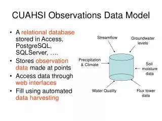
HydroServer Point Observation Time Series Ongoing Data Collection GetSites GetSiteInfo GetVariableInfo GetValues WaterML Historical Data Files ODM Database WaterOneFlow Web Service Horsburgh, J. S., D. G. Tarboton, D. R. Maidment and I. Zaslavsky, (2008), A Relational Model for Environmental and Water Resources Data, Water Resour. Res., 44: W05406, doi:10.1029/2007WR006392
Set of query functions (API) ReturnsdatainWaterML WaterML and WaterOneFlow WaterOneFlowis a set of web services that return data in a WaterML format
GetValues GetVariables qualifier ISO Time value
HIS Central Centralized Observation Catalog with semantic mediation to enable search web services Metadata catalog 66 services; 18,000 variables; 1.9 million sites; 29 million series; 5.1 billion data Values … and growing
USGS Instantaneous Data Real time, instantaneous data over the last 60 days 11188 sites, nationally for the US 80 variables Published by USGS National Water Information System
NCDC Integrated Station Hourly Data Hourly weather data up to 36 hours ago 13,628 sites across globe 34 variables Published by National Climate Data Center and populated with weather observations from national weather services http://water.sdsc.edu/wateroneflow/NCDC/ISH_1_0.asmx?WSDL
Reynolds Creek Experimental Watershed 1 data service 84 sites 65 variables 372 series 17.8 million data Published by USDA-ARS as part of an Idaho Waters project http://idahowaters.uidaho.edu/RCEW_ODWS/cuahsi_1_0.asmx?WSDL
Dry Creek Experimental Watershed (DCEW) (28 km2 semi-arid steep topography, Boise Front) 68 Sites 20 Variables 5924511 values Published by Jim McNamara, Boise State University http://icewater.boisestate.edu/dcew2dataservices/cuahsi_1_0.asmx?WSDL
HydroDesktop Metadata Catalog Data www.hydrodesktop.org
HydroModeler: A HydroDesktop Plug-in Model Directory Explorer Model Configuration Model Attributes
Open Modeling Interface allows models to exchange on a time basis - standard - Software Development Kit (SDK) Metadata www.openmi.org
The Architecture of a Model Component OpenMI Interface Initialize PerformTimeStep Finish Procedural Model Data config.xml Input and Output Exchange Items, Time horizon and step, etc. Supporting Libraries Simple Model Wrapper Castronova and Goodall, 2010, Environmental Modelling & Software
Example Application • Modeling rainfall/runoff for Coweeta Watershed #18 • HIS Server includes publically available Coweeta data • Precipitation: daily accumulated • Air temp: daily min, max, and mean • Stream discharge: daily average Coweeta HIS Server • Mostafa Elag and • Tony Castronova, USC http://river.sdsc.edu/WaterOneFlow/Coweeta/cuahsi_1_1.asmx?WSDL
Coweeta Watershed #18 Watershed #18 Area: 12.48 ha (0.12 km2) 650m by 300 m
Steps in the Hydrologic Modeling Process Revise perceptions The Perceptual Model: deciding on the processes Revise equations The Conceptual Model: deciding on the equations Debug code The Procedural Model: getting the code to run on a computer Revise parameter values Model Calibration: getting values of parameters Model Validation: good idea but difficult in practice Declare Success? No Rainfall-Runoff Modeling: The Primer, Beven, 2001 Yes
Model Development and Application • Do I have the important processes? • Is my mathematical representation of processes sufficient? • Are there bugs in my numerical solution? • Do I have an acceptable parameterization?
HIS Data can be used in other Modeling Systems Object Modeling System v3.0
Example: Accessing HIS Data from within CMT HISData is a CMT component that can search HIS Central and download data from WaterOneFlow web services It allows HIS data to serve as input to CMT models Peckham and Goodall, Computers & Geosciences, Submitted.
Path Forward • Cross-disciplinary science: Interoperability across modeling systems OpenMI Model Interface CSDMS Basic Modeling Interface (BMI) Finalize Getter Initialize Run Setter
CSDMS/OpenMI Interoperability Goal: Import CSMDS Components into an OpenMI modeling environment CSDMS Component Python element of Wrapper OpenMI Model Linking Environment CSDMS Component XML Config File OpenMI Wrapper using IronPython Robert Boykin and Tony Castronova, USC
ESMF/OpenMI Interoperability Goal: Scientific Workflow that couples desktop hydrologic models (wrapped using OpenMI) with HPC climate models (wrapped using ESMF) through web services Project Team: Kathy Saint, Sylvia Murphy, and Cecelia DeLuca -- ESMF Core Team Jon Goodall and Mehmet Ercan -- University of South Carolina Ricky Rood and Laura Briley-- University of Michigan
Common Standards across Earth Science Modeling and Information Systems The Open Geospatial Consortium (OGC®) and the OpenMI Association announced that they recently signed a memorandum of understanding (MOU) to cooperate in standards development and promotion of open standards related to computer modelling. http://www.opengeospatial.org/pressroom/pressreleases/1450 Open Geospatial Consortium (OGC) WaterML 2.0 is a candidate Open Geospatial Consortium encoding standard for the representation of in-situ hydrological observations data. http://www.opengeospatial.org/projects/groups/waterml2.0swg • Observations and Measurements Model • Sensor Web Enablement (SWE) • Sensor Observation Service (SOS) The THREDDS Data Server (TDS) is a web server that provides metadata and data access for scientific datasets, using OPeNDAP, OGC WMS and WCS, HTTP, and other remote data access protocols. www.unidata.ucar.edu/projects/THREDDS
Summary • HIS provides • standards for accessing hydrologic observational data • WaterML, WaterOneFlow API, ODM • software to simplify access and use of hydrologic observational data • HydroServer, HydroCatalog, HydroDesktop, HydroModeler • Agreed upon standards and protocols for component interfaces and data exchanges will facilitate interoperability across earth science modeling and information systems