Download

1 / 10
110 likes | 148 Views
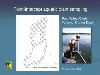
Point-intercept aquatic plant sampling. Ray Valley, Cindy Tomcko, Donna Dustin 19 November 2008. Objectives. Development of plant indicators that reflect status of plant community and habitat Understanding factors contributing to curly-leaf pondweed dominance in lakes.

E N D
Point-intercept aquatic plant sampling Ray Valley, Cindy Tomcko, Donna Dustin 19 November 2008
Objectives • Development of plant indicators that reflect status of plant community and habitat • Understanding factors contributing to curly-leaf pondweed dominance in lakes. • Short-term variability of plant indicators in a range of lakes • Development and publication of a point-intercept protocol. • Suggested sample effort • Indicators to monitor, ways of analyzing • Recommended frequency of assessment
Completing surveys on all sentinel lakes were a collective effort of Area and Regional Fisheries, Research, SWCD’s, SNF. P-I surveys took a fair amount of time on the large sentinel lakes Highlights from 2008
Cooperative U of MN extension & DNR volunteer program that teaches adults about Minnesota`s natural resources- empowers them to educate others and provides opportunities to do conservation projects Mission: to promote awareness- understanding- and stewardship of Minnesota`s natural environment by developing a corps of well-informed citizens dedicated to conservation education and service within their communities Help in 2009 - Master Naturalist Program
1-2 volunteers to help on Aq. plant surveys 1 DNR or SNF Crew leader I forward interest to crew leader, crew leader coordinates logistics Program coord. believes interest will be high Cooperation with Master Naturalist program
Continue sampling 0.7 pt/acre grid with minor tweaks to some lakes (Elk, Cedar, Carlos) to more representatively sample steep slopes Avoid throwing rake over waste lands. Verify plant absence occasionally Record depth at sample point, move to next point Measuring maximum depth of plants (optional) Travel perpendicular to shore from one VP to VP Capture waypoint and depth at edge of plants Save waypoints to shapefile, forward to GIS shop Topic and justification discussed further on SLICE blog Recommended changes in 2009
Best allocation of sampling effort Effort required to robustly yet quickly assess “status” or biotic integrity Stratify effort by depth? 0 – 5 ft zone – most diverse and vulnerable to nearshore disturbance Focus only on areas with substrate supporting veg growth? Issue: should baseline surveys follow this same protocol or be more comprehensive to delineate areas of veg growth and species list? What to look at for final protocol
Many discussion topics on how to analyze data posted to BaseCamp feedback is encouraged i.e., Over what depth do we calculate percent frequency? Constant number (15 ft) – current method Compute over depth ranges? Geostatistics (kriging) the best but most complex way Addresses issues comparing results within/among lakes with differing sample intensity. Evaluates patterns of areal cover Addresses thorny issues of spatial autocorrelation of neighboring survey points. Analysis
Geostatistics - Examples Pearl Survey Points CLP - Kriging
Acoustic Biovolume Point-intercept CLP