Download
1 / 82
840 likes | 1.19k Views
CAD/GIS Interoperability. Rebecca Barber Geographic Mapping Specialist. Presentation Overview. Background Research Interoperability Examples Drafting GIS Features in MicroStation Processing Parcel Line Work Interoperability Tools Beta Testing Summary. Background.

E N D
CAD/GIS Interoperability Rebecca Barber Geographic Mapping Specialist
Presentation Overview • Background • Research • Interoperability • Examples • Drafting GIS Features in MicroStation • Processing Parcel Line Work • Interoperability Tools • Beta Testing • Summary
Background The Florida Department of Transportation (FDOT) requires standardized electronic delivery of Design Plans through CADD. With the advancement of the GIS Enterprise View (GEV) utilizing the FDOT Enterprise GIS Framework and the technology upgrades to CADD platforms supporting the interoperability between these environments, a path for sharing data has evolved so that users in both environments can benefit.
Background • In 2011 FDOT started looking for a way to put everything Right of Way (ROW) related into the new enterprise GIS framework looking backward to historic records • There was some success in manipulating the CADD line work for ROW acquisitions into a GIS environment, but the work was tedious and time consuming • Utilities (a highly desired data set) would be even more tedious
Research • Texas A&M Transportation Institute (TTI) was brought in to examine FDOTs current system, practices and processes • To develop a strategic implementation plan that would manage ROW parcels and utility data • Including a process, workflow and a tool to hopefully “automate” bringing this historical data (CADD line work) into a GIS environment and to give it intelligence This research project was completed in May of 2013
Research • Overview • They conducted site visits and collected CADD Files and Documents. From this they developed • lists of levels, cells, and attributes • database tables, routines, and menus, to extract CADD information desirable to the GIS environment • Recommendations: • Use of existing survey and GEOPAK data to generate parcel shapes • Use a database approach for managing design libraries and levels in MicroStation to be able to • link information • and add attribute data • Created steps for integrating existing parcel and utility data into FDOT’s enterprise GIS framework
Research • But, there is no true “automation” available • There is too much drafting cleanup needed on the historical data • So getting the historical data into a GIS environment will be mostly manual, even with the tools developed by TTI • So where do we go from here? • We can began to gather new data, • while trying to come up with a plan for the old data
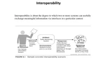
Interoperability • What does that mean? • It means that you can take line work from a CADD application, give it intelligence and export it into a GIS application • Or take intelligent data from a GIS application and import it into a CADD application • Since this data has intelligence you can do queries, its not just about turning off layers/levels • Say you only want to see roadways that have a speed limit of 55mph.....you can do that • Or say you only want to see parcels over/under a certain acreage...you can do that too
Interoperability • FDOT anticipates that one day the ability to reference all or some amount of historical layers such as • Survey Control, • Parcels, • Aerials, • ROW, • Roadway, • Easements, • Utilities, and Permit Agreements • In both CADD and GIS platforms • FDOT sees this information as having great value in areas of informed decision making or maybe even those creating high amounts of public record requests • Technology is moving in that direction with both the Bentley and AutoCAD platforms now supporting importing and exporting of GIS data
Interoperability • So….. • How can we integrate CADD Survey/Engineering data that’s symbolized specifically to create a set of design plans for construction so that elements of that design can be visualized/attributed and thereby successfully used in a Geographic Information System?
Interoperability Requirements • Before we can begin to answer that question we must first have an understanding of what it is that GIS requires in order to visualize and geospatially query information • GIS uses relational tables of records that are geospatially aware • Along with linked attribute data • In short--- Attributes Data Intelligence • So that means that we must somehow create outputs in the CADD environment to meet these requirements
Interoperability • Goals • Use existing licensed products (both CADD and GIS) • Reach out and determine all potential stakeholders to data • There may be some who traditionally were not interested or didn’t have a need to mine CADD data from design plans as they were not CADD users and the data had no intelligence • User assessment to identify initial need and priority of GIS features • Start small • Right of Ways • Parcels (both right of way and excess) • Alignments • Determine workflows, and • Build tools and workspaces in FDOT CADD platforms for creating these GIS features
Interoperability • Incorporating GIS workspaces into the current FDOT workflow • Creating intelligent data is data that is both • Geospatially aware, and • Has attributes • Following is an example showing the FDOT tool CADD designers can use to create intelligent features in a CADD environment by either • Placing or • Promoting existing CADD elements
Example CADD Components Exported as GIS Features
Baby Steps • Using Bentley Geospatial Administrator • A FDOT GIS workspace was created and released with FDOTSS2 MR1 (Feb 14, 2014). This workspace enables the: • Creation of GIS Features With Attributes (intelligent data) • Parcels (polygons) • Right Of Way Lines (line) • Alignment (line)
Baby Steps • The biggest problems are: • Drafting quality • No more sloppy drafting • Closed polygons • Data Cleanup • Good clean data is needed in order to Promote the line work into GIS Features • Using the information already in the GeoPak project .gpk files and the Design & Computation Manager to visualize elements and then Promote into GIS Features • Polygons must be a Complex Shape • NOT a Complex Chain
Bentley Map Power GEOPAK V8i Select Series 2 with FDOTSS2 MR1 (released Feb 14, 2014) Includes new geospatial tools: Interoperability tools Map Manager Attaches files and features from any supported graphical source (such as vector maps and raster images) and manage feature display Feature Menu Command Manager Allows for the placing, editing, promotion, analyzation and browsing of feature attributes
Design & Computation Manager Two GIS Categories have been added to the Design and Computation Manager: • Use these GIS categories to visualize “raw” line work for promotion to Bentley Map GIS features. • Once plotted and before being promoted to a Bentley Map GIS feature, line work like: • Alignments and Right Of Way lines • Need to be turned into continuous poly-lines. • Parcels • Need to be turned into polygons before being promoted.
Design & Computation Manager When visualizing parcels; choose the category that best fit the type of take that will be promoted. Generally choose the category based on the type of easement involved in the take. Note: Do not visualize labels. Labels are not necessary and will not be carried over to GIS when the lines and parcels are promoted.
Design & Computation Manager As an example here is a parcel that includes a temporary easement, parcel 708, and is used to visualize the raw parent tract, fee take (108) and the temporary easement (708) all at the same time.
After the parcels are visualized from the D & C Manager, now what? Processing parcel Line work
TempEaseParcelRaw FeeSimpleParcelRaw
Command Manager Interoperability tools
Note: Commands are categorized by discipline in this example, but could be categorized/organized in other ways. Command Manager Tree
Command Manager Combo Box
Command Manager Place
Place Edit
Place/Create/Edit Parcels
Parcels Promote Existing to Parcel