Download
1 / 17
170 likes | 310 Views
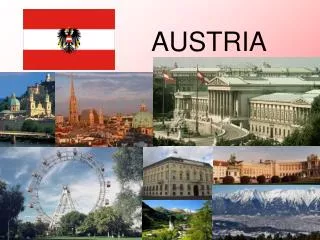
Téma hodiny: Geografie Österreich s Předmět: Německý jazyk Ročník: 4. ročník Klíčová slova: Oberfläche, Gewässer, Klima, Film Autor: Mgr. Sandra Vanišová Škola – adresa: SŠHGS Litoměřice, Dlouhá 6, Litoměřice. Geografie Österreichs. Was wisst ihr über Geografie Österreichs?

E N D
Téma hodiny: Geografie Österreichs Předmět: Německý jazyk Ročník: 4. ročník Klíčová slova: Oberfläche, Gewässer, Klima, Film Autor: Mgr. Sandra Vanišová Škola – adresa: SŠHGS Litoměřice, Dlouhá 6, Litoměřice
Geografie Österreichs Was wisst ihr über Geografie Österreichs? Ist Österreich eben oder gebirgig? Wie heißt der höchste Berg Österreichs? Wie heißen die wichtigste Flüße Österreichs? Wie heißen die größte Seen Österreichs?
Oberfläche • Die Oberfläche Österreiechs ist sehr vielfältig • Es gibt hier fünf verschiedene Landschaftsräume: • Ostalpen (die höchste Gebirge Österreicchs – Ötztaler und Zillertaler Alpen und die Hohen Tauern mit dem höchsten Berg Österreichs, dem Großglockner) • Alpenvorland und Karpatenvorland
3) Vorland im Osten (Anteil am Pannonischen Tiefland) 4) Wiener Becken 5) Granit- und Gneishochland (Anteil an der böhmischen Masse)
Österreich Zdroj: http://www.treking.cz/sluzby/rakousko-strediska.htm
Österreich Zdroj: http://cs.wikipedia.org/wiki/Soubor:Austria_satellite-map.jpg
Die höchsten Berge Österreichs • Großglockner (Hohen Tauern) – 3797 m • Wildspitze (Ötztaler Alpen) – 3768 m • Weißkugel (Ötztaler Alpen) - 3730
Großglockner Zdroj: http://www.alpy.net/grossglockner/grossglockner.php
Wildspitze Zdroj: http://cs.wikipedia.org/wiki/Soubor:Rakouske_alpy_3.jpg
Weißkugel Zdroj: http://en.wikipedia.org/wiki/File:WeisskugelFromN.jpg
Gewässer • Österreich ist ein Binnenstaat, hier gibt es also kein Meer Die Wichtigsten Flüße • Der wichtigste Fluss ist die Donau(2860 km lang, davon in Ö. 350 km), die Donau ist der zweitlängste europäische Fluss • Donau ist nicht nur wichtiger Wasserweg, sondern auch wichtige Energiequelle • Alpenflüße Inn, Mur, Enns, Salzach und Drau sind zwar wasserreich, aber nicht schiffbar • An ihnen wurden mehrere Wasserkraftwerken errichtet (in Ö. Gibt es mehr als 1000 Wasserkraftwerke)
Seen • In Österreich gibt es cca 600 Seen Die größten Seen: • Bodensee (538 km², davon in Ö. 24 km²) • Neusiedler See (335 km²) - salzhaltig • Attersee (47 km²)
Bodensee Zdroj: http://rakousko.svetadily.cz/clanky/Bodamske-jezero
Klima • Innerhalb Österreich lassen sich drei klimatische Zonen unterscheiden. Der Osten ist vom kontinentalen Klima geprägt, die inneralpinen Regionen stehen unter dem Einfluss des alpinen Klimas (kurze Sommer und lange Winter), im übrigen Gebiet herrscht Übergangsklima mit ausreichenden Niederschlägen.
Zweiter Teil eines Dokumentarfilmes über Österreich (cca 13 Minuten) • http://www.youtube.com/watch?v=Dt4TNkzGL6M&feature=relmfu
Použité zdroje: ANDĚL, J., MAREŠ R. (2001): Evropa. Encyklopedický přehled zemí. Nakladatelství Olomouc, Olomouc, 293 p. HOMOLKOVÁ, B. (2005): Reálie německy mluvících zemí. Nakladatelství Fraus, Plzeň, 116 p. WIKIPEDIA [online]. [cit. 2012-07-22]. Dostupné z WWW: <http://cs.wikipedia.org/wiki/Soubor:Rakouske_alpy_3.jpg> WIKIPEDIA [online]. [cit. 2012-07-22]. Dostupné z WWW: <http://en.wikipedia.org/wiki/File:WeisskugelFromN.jpg> TREKING.CZ [online]. [cit. 2012-07-22]. Dostupné z WWW: < http://www.treking.cz/sluzby/rakousko-strediska.htm> ALPY. NET [online]. [cit. 2012-07-22]. Dostupné z WWW: < http://www.alpy.net/grossglockner/grossglockner.php> SVĚTADÍLY.CZ [online]. [cit. 2012-07-22]. Dostupné z WWW: < http://rakousko.svetadily.cz/clanky/Bodamske-jezero> WIKIPEDIA [online]. [cit. 2012-07-22]. Dostupné z WWW: < http://cs.wikipedia.org/wiki/Soubor:Austria_satellite-map.jpg> YOUTUBE [online]. [cit. 2012-07-22]. Dostupné z WWW: <http://www.youtube.com/watch?v=Dt4TNkzGL6M&feature=relmfu>>