Download
1 / 57
580 likes | 598 Views
Learn about the population and habitat trends of Bank Swallows along the Sacramento River, conservation strategies, and restoration efforts. Discover the importance of riparian and floodplain vegetation for these threatened species.

E N D
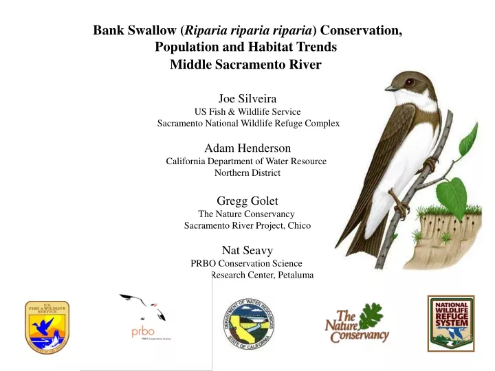
Bank Swallow (Riparia riparia riparia) Conservation, Population and Habitat Trends Middle Sacramento River Joe Silveira US Fish & Wildlife Service Sacramento National Wildlife Refuge Complex Adam Henderson California Department of Water Resource Northern District Gregg Golet The Nature Conservancy Sacramento River Project, Chico Nat Seavy PRBO Conservation Science SF Bay Research Center, Petaluma
Presentation Outline • Bank Swallow, Breeding Colonies & the Sacramento River • Population & Habitat Trends – Middle Sacramento River • Bank Swallow Habitat, Restoration and Management • California Department of Fish & Game / Sacramento River NWR Conservation Plans • Bank Swallow Technical Advisory Committee – Bank Swallow Conservation Strategy Middle Sacramento River
Bank swallow (Riparia riparia riparia) • Smallest (& cutest) Swallow • Migratory – Neotropical • Colonial Nesting • CA Threatened Species • RHJV Focal Species • TNC Ecological Flows Study Terrestrial Indicator Species
Over 70 % of the California BANS Population Breeds on the Sacramento River & it’s largest tributary, the Feather River Reach 1 Redding to Red Bluff _____________ Reach 2 Red Bluff to Chico Landing _____________ Reach 3 Chico Landing to Colusa ______________ Reach 4 Colusa to Verona
Sacramento River Reach 2 & 3 Sinuosity; over-bank flooding, erosion & deposition; lateral channel migration, floodplain re-working; on-channel meander loops, off-channel oxbow lakes, floodplain sloughs
Patterns of Riparian & Floodplain Vegetation Cottonwood Forest Valley Oak Forest Willow Scrub
THE BANK SWALLOW ON THE SACRAMENTO RIVERCDFG Bank Swallow Research Program, 1986 – 2007 Ronald W. Schlorff & Barrett A. Garrison Survey, Habitat Assessment & Monitoring • Survey: Sacramento River (1986); Statewide (1987) • Burrow counts, Reproductive Studies, Habitat Assessment, Banding, Colony Research • Monitoring: Sacramento River, 1988 – 2007 • Burrow Counts, Habitat Assessment
Barry Garrison Riparia riparia riparia Allan Brooks Louis Agassiz Fuertes
Bank Swallow Population Trend1986 – 1998 Recovery Plan & PVA Nesting Pairs Listed as Threatened 1992 1986 1989 1998 Year
Bank Armoring (Rip-rap) Identified as a Major Cause of Habitat Loss
Annual BANS Colony Population Survey – Sacramento River & Tribs Survey Crew 1, 2, 3, 4, ………. 1,093, 1,094, 1,095, 1,096………. Bank Swallow Colony
Annual Bank Swallow Survey: Sacramento River Red Bluff (RM 243) to Colusa (RM 143)
Annual Bank Swallow Survey: Sacramento River, Red Bluff (RM 243) to Colusa (RM 143)
Trend for fewer, larger colonies 1986 2008 2007 – 8 Colonies contained 49% of the BANS Population
Dawn Garcia Dr. Coleen Hatfield QA/QC & Analysis of 10 Years of BANS Population Data relative to Over – Bank Vegetation, Erosion, Sinuosity & Flows CSu CHICO
BANKS OF THE SACRAMENTO1995, 2002, 2007 A product of the Environmental Services Section Northern District, Division of Planning and Local Assistance Department of Water Resources Adam Henderson (Reach 2 – 2007)
….and other categories as needed, such as 1956-ish rusty Desoto
Erosional Depositional Stable
Meters of riprap Year
High Quality Bank Swallow Habitat – River Mile 233.5 Left – BANS 2007 Survey = 1,191 Burrows
Low Quality BANS Habitat Low Gradient, Low Profile Banks (Over Gravel & Sand)
Predation & Habitat Quality Snakes access burrows from over-hanging branches & exposed roots Mammals from low banks
No matter the habitat quality, it will change……… Medium Very High Low
being lost & created as the channel meanders BANS Habitat is Ephemeral..
Recent alluvium has not yet developed pedogenic “acquired” soil horizons– they are “inherited” through the various associated dynamic energies at the time of deposition, and on top of this, channel migration / floodplain reworking further mixes and creates new (inherited) horizons– resulting in unpredictable, azonal stratigraphic soil texture horizons across the recent (100-year) floodplain Columbia & Gianella Soils with & without gravel lenses
Floodplain Mapping Sacramento River NWR – Deadman’s Reach Unit Orchards & Vicinity
Floodplain Mapping Sacramento River NWR – Rio Vista Unit Restoration & Vicinity
Soil Pits – silt loam Sacramento River NWR – La Barranca Unit
Soil Pits – silt, sand, gravel Sacramento River NWR – La Barranca Unit
Soil Pits – clay & sand Sacramento River NWR – La Barranca Unit
Privately “installed” rubble prior to USFWS acquisition potential for removal and habitat restoration
Floodplain Restoration – Flynn Unit Summer/Fall 2001
Levee removal completed Fall 2001 Sacramento River floods, bank fills & collapses (Winter 2001- 02)
BANS Survey June 2002 Flynn Unit = 2,770 nesting pairs
Soil Sampling of Bank Swallow ColoniesSacramento River Aug-Sept, 2009 – 2010 Dean W. Burkett USDA-Natural Resources Conservation Service Joe Silveira USDI-Fish and Wildlife Service Koll Buer California Resources Agency-Department of Water Resources
Stops 1 and 2, Soils, Rm, 1997 & 2004 channel, Colonies, 100yr flood
Sampling Strategy Soils sampled in use and non-use areas to determine preferred texture Use Non-Use Use
Summary of Data Yellow = Use area (burrows) Soil Textures: Sand, Loamy sand, sandy loam, loam Clay range: 1-15 % Blue = Non-use area Soil Textures: Sandy loam, Loam, Silt loam Clay range: 10-20 %
Floodplain Restoration – Pine Creek Unit 2010: 450 acres of riparian grassland restoration


![[PDF] Lantern's Light By James Swallow Free Downloads](https://cdn4.slideserve.com/8196789/slide1-dt.jpg)