Download
1 / 19
190 likes | 205 Views
Learn how to easily locate features on a topographic map using grid & area references. Discover the significance of eastings, northings, and 6-figure grid references. Test your skills and explore helpful interactives.

E N D
Grid & Area References It can be difficult to find places or features easily on a map.
Topographic maps are large scale and we use these for Area and Grid references
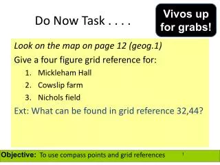
So how do we locate features on a Topographic map? • http://news.bbc.co.uk/2/hi/uk_news/wales/north_west/7824895.stm • This BBC link details the importance of Grid References for emergency services to reach rural areas. • We can locate places easily on a topographic map by using the maps gridlines. • On a topographic map the vertical( )lines are called eastings because they increase in value as we move eastward. • The horizontal ( ) lines are called northings because they increase in value as we move northwards.
18 17 16 N 15 Northings 22 23 24 25 26 27 Eastings
Area Reference • Features such as a small lake, quarry or village are usually located by means of an Area Reference (AR) • To find the (AR) of a feature we use the coordinate in the lower left-hand corner of the grid square in which the feature is located. • You always read the easting first then the northing. (hint to remember E comes before N in the alphabet) • An area reference always has 4 figures • Into the house and up the stairs” may help you remember!! EXAMPLE: AR3363 easting northing
The Area Reference of the house is: AR2317 18 Remember with (AR) you use the bottom left hand corner 17 What is the (AR) for: The plane: AR2215 16 The boy: N AR2316 15 22 23 24 25 26 27 Northings Eastings
Area references Time now for a little test. FOUR squares are going to be highlighted and you have TEN seconds to write down the area reference for each square. 39 A 10 9 8 7 6 38 5 4 3 2 1 A 37 36 CLICK to start..... CLICK for the next square 35 21 22 23 24 25 26
Area references 39 A 10 9 8 7 6 38 5 4 3 2 1 B 37 B 36 CLICK for the next square 35 21 22 23 24 25 26
Area references 39 A 10 9 8 7 6 38 5 4 3 2 1 C 37 B 36 C CLICK for the next square 35 21 22 23 24 25 26
Area references 39 A 10 9 8 7 6 38 5 4 3 2 1 D D 37 B 36 C CLICK for the next square 35 21 22 23 24 25 26
Area references A = 2238 B = 2536 39 A C = 2235 38 D = 2337 D 37 B 36 C 35 21 22 23 24 25 26 How did you get on? CLICK TO CHECK EACH ANSWER
Grid References • We can locate relatively small and more specific features on map by using Grid Reference (GR). • (GR) locates the exact point on the grid. • Unlike (AR), Grid Reference uses 6 figures. -The first two numbers of each coordinate refers to the eastings and northings that surround the map. - The third number needed to complete each coordinate is obtained by dividing each easting and northing into tenths. Dividing the easting and northing into tenths Example: GR335638 easting northing
What is the grid reference (GR) for the ball in which the boy is about to catch? 18 17 Answer: GR238169 16 N 15 22 23 24 25 26 27 Northing Eastings
Come up to the Interactive White Board 6-figure grid references
68 F H I D A 67 C G B E 66 23 24 21 22 A C G D F H I J B E A Compass Directions N NW NE W E J SE SW S What direction are you walking ?
Interactives • http://mapzone.ordnancesurvey.co.uk/mapzone/PagesHomeworkHelp/maptivity/gridreferences/ • http://geographyfieldwork.com/TestGridIntro.htm
CLASS EXERCISE • Give the (AR) for the following features: • Church; • Village Hall; • Grove farm; • The dairy farm; • The town of Little Plumpton; • The entire (AR)’s for Gibbet Wood; • The (AR)’s that Dale Road passes through; • The approximate (GR) of Grove farm.
Interactives • http://www.mape.org.uk/startower/maps/resources/map1.htm • http://www.mape.org.uk/startower/maps/resources/map1b.htm