Download
1 / 34
450 likes | 1.07k Views
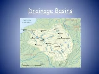
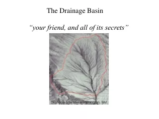
Drainage Basin. Part I Morphological Systems. Contents. Drainage Basin Cycle Stream Characteristics Stream channel Stream flow Hydrograph Fluvial Morphology Basic form elements of a fluvial erosion landscape. Measurements Drainage patterns. Drainage Basin Cycle.

E N D
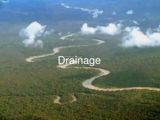
Drainage Basin Part I Morphological Systems
Contents • Drainage Basin Cycle • Stream Characteristics • Stream channel • Stream flow • Hydrograph • Fluvial Morphology • Basic form elements of a fluvial erosion landscape. • Measurements • Drainage patterns
Stream Characteristics • Stream Channel • Stream flow • Hydrograph
Stream Channel • Channels may be thought of as a long, narrow trough, shaped by the forces of moving water. • Depth: • It is measured at any specified point in the stream as the vertical distance from the surface to bed. • Width: • It is the distance across the stream from one water edge to the other. It may be so narrow that a person can jump across them, or as wide as 1.5km (eg. Mississippi, Changjaing)
Stream Channel • Cross sectional area (A): • It is the are in square metres or square feet. • Wetted perimeter (P): • It is the length of the line of contact between the water and the channel. • Channel Slope (S): • It is the angle between the water surface and the horizontal plane. • Eg. 50cm/km: it means the stream surface undergoes a vertical drop 50cm for each 1km of horizontal distance downstream. • Eg. 0.03 means the stream drops 3 m for ever 100m of horizontal distance.
Stream Flow • Velocity: • Gravitational force causes stream flow. • Water close to the bed and banks moves slowly that in the deepest and most centrally located zone flows faster. • Water will flow faster in a channel of steep gradient than one of low gradient. • Mean velocity (V) in streams is commonly equal to about 60% of the maximum velocity. • Discharge (Q): • It is the volume of water passing through a given cross section of the stream in a given unit of time. (m3/s) • Q = VA
Stream Flow • The optimum channel would be semi-circular shape in cross section. • For Q=VA • As velocity ‘V’ increases, cross-sectional area ‘A’ must also decrease. • Q = VA (waterfall, rapids,……) • As cross-section area ‘A’ increase, velocity ‘V’ must increase. • Q = VA (lake, delta, estuary…..)
Hydrograph • It shows the variation of discharge with time at a certain location of a river.
Components of hydrograph • Discharge: • It is the amount of water flow in the river. It varies over times and place to place. • Base flow: • It is much more constant in amount and the water level is nearly the same. • It is discharged from delayed ground water flow in soil during ordinary time. • Rainfall: • Its intensity is partly responsible for the magnitude of the peak.
Components of hydrograph • The peak: • It shows the maximum flood level. • Rising limb: • Its steepness determined by the rate of surface runoff. • The higher the peak, shorter the basin lag with the steeper rising limb. • Basin lag: • It is the time between the heaviest rain and the peak. • The lag is determined by the nature of soil moisture, the structure, relief of the basin and the intensity of the rainfall. • Recession limb: • The rate of passing flood.
Hydrograph • It is great use to engineers and hydrologists in planning of irrigation, drainage system, power (HEP) development, water supply and flood forecasting. • In many parts of the world, spring is a time of floods for spring rain and snow-melt. • Although some rivers flood quite regularly, the recurrence interval varies from basin to basin and varies with the magnitude of the flood.
Shape of hydrographs • The variation of the hydrograph shape from basin to basin, which shows the dependence of the discharge on geological and morphological characteristics of a drainage basin. • A flash stream has a hydrograph with sharp peak, for high immediate surface runoff, with little absorption and storage of water in the basin.
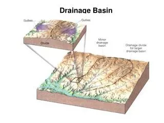
Fluvial Morphology • Measurement of geometrical properties of the land surface of a fluvial erosion system. • Basic form of a fluvial erosion landscape. • Linear Properties of Stream Channel system • Areal Properties of Drainage Basin • Relife Properties of the Fluvial System. • Measurement • Stream Orders • Stream Numbers • Stream Length • Stream Slopes • Basin Areas • Drainage Density Density and Texture of Topography • Drainage patterns
Basic form elements • Linear Properties of the stream channel. • They are the numbers, lengths and arrangements of sets of line segments. • Areal Properties of Drainage Basin • It is a two-dimensional properties, includes size and shape. • Relief Properties of the Fluvial system. • Relative heights of points on surfaces and lines with respect to the horizontal base of reference. • It is a vertical dimension, includes gradient of ground surface and stream channel, rate of drop of the runoff and measures of the intensity of the processes of erosion and transportation.
Stream orders • Each fingertip channel is a segment of the first order stream. • Two first order streams merge to form second order streams and so forth. • The trunk stream of any watershed bears the highest order number of the entire system. • First and second order streams usually carry flowing only in wet weather.
Stream orders – Bifurcation Ratio • The order of a stream segment is designated by ‘u’. • The bifurcation ratio (Rb) is defined as
Stream orders – Bifurcation Ratio • If the region of uniform climate, rock type, and stage of development, the bifurcation ratio tends to remain constant from one order to the next (3 to 5)
Stream Numbers • R.E. Horton: “The numbers of stream segments of successively lower orders in a given basin tend to form a geometric series, beginning with a single segment of the highest order and increasing according to a constant bifurcation ratio.” • Eg. Bifurcation ratio is 3, the trunk segment is the sixth order, the number of segments will be 1, 3, 9, 27, 81 and 243.
Stream Numbers • The formula should be • The total numbers of stream segments of the entire drainage basin should be
Stream Length • The 1st order stream segments have the shortest length, and the segments become longer as order increases. • The mean length of stream segments increases by a length ratio (R1) with each increase in stream order.
Stream Length • R.E. Horton: “The cumulative lengths of stream segments of successive orders tend to form a geometric series beginning with mean length of the 1st order segments and increasing according to a constant length ratio.”
Stream Slopes • Slope is stated as a ratio. • 0.01 is a ration of 1:100. (a drop of 1 metre vertically in 100 metres horizontally). Profile a and profile b have the same slope
Basin Areas • Horton:” The mean basin areas of successive stream orders tend to form a geometric series beginning with mean area of the first-order basins and increasing according to a constant area ratio.” • Usually, the discharge of a stream increases with increasing drainage area.
Drainage Density • This is found by measuring the total length of all of the streams within the basin. (km/km2) • Drainage density are controlled by several factors, but the most import control factor is infiltration capacity.
Factors affecting infiltration capacity • Geology (Rock or soil type) • Hard, resistant rocks (granitic rock): low density • Weak rocks (shale and clay): high density • Permeable rocks or soil (sand): low density • Impermeable rocks or soil (clay): high density • Topography • Steep slope: high density • Gentle slope: low density • Vegetation • Forest: low density • Farmland: medium density • Badland /desert: high density • Climate • High rainfall: high density • Light rainfall: low density
Drainage patterns • Drainage patterns are largely controlled by two factors • Slopes of the drainage area • Local differences in the resistance of rocks or geological structures (faults….) • http://www.il-st-acad-sci.org/kingdom/geo1005.html
Drainage Patterns • Dendritic Pattern • Rectangular Pattern • Trellised Pattern • Radial Pattern • Centripetal
Dendritic Pattern • Tree-like, random branching pattern developed in a region of uniform or homogeneous rock.
Rectangular Pattern • It is a rectilinear or grid-like pattern developed in a region with strong marked joint systems or faults intersecting at approximately right angles. • This pattern is largely controlled by structural weakness.
Trellised Pattern • It is a rectilinear stream pattern developed in region of alternate layers of resistant and less resistant rocks which dip in the same direction. • The streams join one another at right angles
Radial Pattern • A radial pattern of drainage is a stream pattern developed on a structure dome, volcanic cone, uplifted fault block or a conical hill.
Centripetal Pattern • It consists of streams drainage from different directions towards the centre of a depression or basin. • It is very common in inland drainage system, where streams terminate ina lake at the centre. • Streams in intermontane basin or desert basins often develop this pattern.