Download
1 / 16
160 likes | 270 Views
Integrated Valuation of Marine Coastal Ecosystem Services –Overview . Murray Patterson School of People, Environment and Planning, Massey University Presentation to the Project Inception Workshop 4 December, 2012. Purpose of the Presentation.

E N D
Integrated Valuation of Marine Coastal Ecosystem Services –Overview Murray Patterson School of People, Environment and Planning, Massey University Presentation to the Project Inception Workshop 4 December, 2012
Purpose of the Presentation The purpose of this presentation is outline the programme’s : • Aims • Rationale and Philosophy • Key methodological steps Please ask questions and have a discussion. Nothing is ‘set concrete’ at this stage !!!!
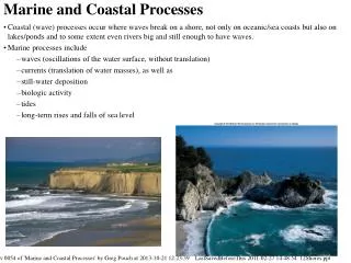
Programme Aim and Scope (Yrs 1-2) • Our aim is to develop a robust framework to characterise, biophysically quantify, map and value coastal-marine ecosystem services. • The intention of the research is to ‘make visible’ coastal-marine ecosystem services that are often ignored in resource management and business decision-making. • We will use Tasman Bay as a test-bed for our research in years 1 & 2, with further research signalled in the full proposal.
Programme Aim and Scope (Yrs 3-4) • At this stage, there is no guarantee that will fund of years three and four • However, our proposal indicated that Years 3-4 would: • Extend the valuation/quantification method to cover all of New Zealand’s coasts and oceans • More fully develop the valuation/quantification method to find solutions to resource management problems – ‘exemplar’ case studies • Apply valuation/quantification method to a national scale marine policy issue.
Programme Steps STEP 1 Conceptualisation of Ecosystem Services in Tasman Bay • No one unequivocal conceptual framework service • Much debate over terminology and methodological issues such as double counting • Most classification systems have been developed for terrestrial ecosystems • Social and cultural dimensions are important Step 1 will be particularly important in the first few months, but will continue the lifespan of the programme
STEP 2: Biophysical Quantification and Mapping Step 1: Ecosystem Services Conceptual Framework Step 2a: EcologicalUnderstanding of Tasman Bay Step 2b: Ecosystem Services Indicators for Tasman Bay, defined in biophysical terms (Ideal) Investigate ways of generating missing GIS layers. Limited funding to do this in Years 3 and 4. • Step 2c: • GIS Data Layers for Tasman Bay • Substrate Layers • Seabed benthic communities and habitats • Water Column hydrology • Water column biology • Human Activities Step 2d: Reality Check IF no GIS data, then can’t quantify and map Step 2e: Maps of ecosystem Services indicators for Tasman Bay, defined in biophysical terms (Approx 15-20 maps) Step3: Economic Valuation
Programme Steps STEP 3 Is there times series data available? If so we could generate ‘radar diagram’ like this, which is good for non-commensurable physical units:
Programme Steps STEP 3 Economic Valuation of Coastal Marine Ecosystem Services • Biophysical indicators converted to economic values maps economic values of ecosystems • Main economic valuation methods to be used will be: • Avoided cost • Replacement cost • Hedonic pricing • Contingent valuation • Benefit transfer • Other non-monetary metrics will be used as appropriate • Cultural Values • Intrinsic Value • Contributory Value • One critical/reflective article on limitations of these valuation methods, will be produced
Programme Steps STEP 4: Matauranga Maori interpretation of ecosystem services Research questions include: • How relevant is ecosystem services concept from an Matauranga Maori perspective? • All too often cultural values as seen just as ‘another category’ ecosystem services – a box to be ticked off. Is this appropriate or are the better ways of approaching the problem. • Can an we diviise alternative framework to ‘ecosystem services’ for hapu/iwi? One report will be produced to summarise these issues, and provide guidance hapu/iwi. • Dr Huhana Smith, Aroha Spinks, April Bennett, Dr Anthony Cole, Dr Kai Chan
Programme Steps STEP 5: Application to a Practical Problem in Nelson Bays • ‘Short-sharp’ application – only two or three months • Years 3-4 will focus more on applying the method to practical problems. • Any suggestions ?
Study Boundaries? • Tasman Bay and Golden Bay? Or just Tasman Bay? (By including Golden Bay to do capture any extra ecosystem services or processes? • How far out to sea?
Documentation • Detailed Methodology (7 pages) • Full Proposal – minus CVs (32 pages) Everyone should have a copy of these
The Research Team Massey University Murray Patterson (Science Leader) Research Fellow (to be appointed) Cawthorn Institute • Joanne Paul Gillespie or Chris Cornelisen to provide this overview.
Rationale for the ecosystem services approach • Makes ecological processes/functions visible • Can compare ecological values and economic values in same terms • We intend to shift thinking about coastal-marine management away from a fragmented concentration on single issues, single processes and single resources, to a more holistic appreciation of the whole-of-system ecosystem services values and processes
Example chapter Chapter 20: Nitrogen Cycling and Storage 20.1 Importance to Nelson Bays Ecology [1 page] 20.2 Describe and Quantify Nitrogen Processes [2 pages] 20.2.1 Flows 20.2.2 Sinks (Stocks?) 20.2.3 Box Diagram 20.3 Key indicators (from 20.1 and 20.2) [0.5 page] 20.4 Spatial dimension [1 page, more if more indicators] 20.5 Temporal dimension [1 page] 20.6 Forward Links to Regulation and Provision services [0.5 page] 20.7 Stressors (natural/human) on nitrogen processes [1 page] 20.8 Valuation [2 pages] 20.9 Policy Messages and Implications [1 page]