Download
1 / 18
180 likes | 189 Views
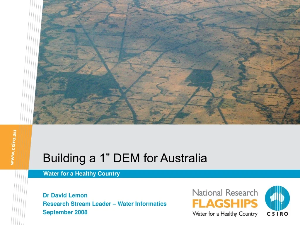
Building a 1” DEM for Australia. Water for a Healthy Country. Dr David Lemon Research Stream Leader – Water Informatics September 2008. Introduction to geography of Australia. Growing Urban Demand. Over-allocation to Irrigation. Drying & Warming Climate. Expanding Plantations.

E N D
Building a 1” DEM for Australia Water for a Healthy Country Dr David Lemon Research Stream Leader – Water Informatics September 2008
Introduction to geography of Australia Insert presentation title
Growing Urban Demand Over-allocation to Irrigation Drying & Warming Climate Expanding Plantations Uncapped Groundwater Extraction Bushfire Recovery Impacts Expanding Farm Dams The Environmental Flows Imperative Water scarcity: A deepening problem. 8 Water Scarcity Factors Insert presentation title
Options for a new National DEM • The 9 second (250 m) DEM is the only national bare-earth DEM • Does not meet requirements • ALOS PRISM/PALSAR • 5-10m postings & 3-10m Z (DTED2.5) • Requires large investment in photogrammetry • SPOT HRS • 20m postings 10-15m Z (DTED2) • COTS solution • Requires large investment in data and photogrammetry for DEM • SRTM • DTED2 a significant improvement on DTED1 • Existing Regional DEMs and Elevation data • Not a national coverage Insert presentation title
Options for the New National DEMSRTM • SRTM DTED2 (1sec) will open up the interior of Australia • There is information on landscape structure never seen before • Significant advancement on current 9sec DEM • Work on 3sec SRTM has proven problematic and would require enormous investment in manual editing • SRTM DTED2 has proven to be more suited to automatic artefact and vegetation removal. • Moving from 3 second to 1 second takes us beyond a visually attractive product to one that is usable for serious quantitative purposes • Major investment will still be required in manual editing and data integration • All other options are very expensive • Likely to be made obsolete by new data sources within 5 years STRM DTED2 (1sec) offers the the most consistent and cost-effective platform for the next National DEM 9sec DEM 1sec SRTM DEM Insert presentation title
Effects of different DEM types and resolutions 9 second SRTM 3 second SRTM 1 second Regional 25 m Lidar 5 m Insert presentation title
SRTM and 9 second in the arid zone Insert presentation title
SRTM cleanup Insert presentation title
Processing steps • Fourier transform filtering to remove systematic stripes (sensor artifacts) • Removal of vegetation offsets • Identification of affected areas using vegetation mapping from remote sensing and direct detection from DEM • Measurement of vegetation height offset and construction of vegetation height surface • Removal of height offset in affected areas • 1 second data greatly facilitates this process • Adaptive smoothing to reduce random height variations in flatter areas • Drainage enforcement with ANUDEM using mapped streams • Quality assurance yet to be performed • Manual intervention will be required in some areas Insert presentation title
Fourier filtering for de-striping • This is one of the worst affected areas on all of Australia, but the artefact in a subtler form is widespread • Not yet fully optimised – some stripes remain Insert presentation title
Vegetation detection Insert presentation title
Vegetation offset removal Insert presentation title
Adaptive smoothing Insert presentation title
Drainage enforcement Insert presentation title
SRTM 1 contribution to catchment delineation 150 148 146 144 0 10 20 km Insert presentation title
Key advantages of 1 second data • Cleanup of SRTM data is much easier and much more effective using the 1 second data • 3 second data blurs the edges we need to identify for vegetation removal • Released product ideally based on 1 second, not 3 second • Quantitative analysis demands better than 3 second data • Representing surface shape • Capturing correlations with soil properties • Matching natural and constructed features in the landscape Insert presentation title
Summary • SRTM cleanup process is operational • Room for improvement, development is continuing • 1 second data provides much better basis for veg removal • QA and correction will be required before release • Currently scoping effort required • Cleaned SRTM without drainage enforcement can provide a useful DEM for non-hydrological purposes • Vegetation height information as a byproduct • With appropriate stream data SRTM can construct the geospatial fabric for water resource management, in combination with other DEMs as necessary • Release of SRTM 1 second data would enable a host of applications that are not possible with pre-SRTM data and have limited value using 3 second SRTM Insert presentation title
CSIRO Land and Water Dr David Lemon Research Stream Leader – Water Informatics Phone: +61 2 6246 5724 Email:David.Lemon@csiro.au Web: www.csiro.au/clw Thank you Contact UsPhone: 1300 363 400 or +61 3 9545 2176Email: Enquiries@csiro.au Web: www.csiro.au