Download
1 / 3
0 likes | 5 Views
#landsurveyorOKC, #GPSsurvey, #civilengineering, #surveyingcompanynearme, #aerialtopographicsurvey, #altasurveying, #landsurveying, #oklahomasurveyor, #oklahomalandsurveying, #topographicalsurvey,

E N D
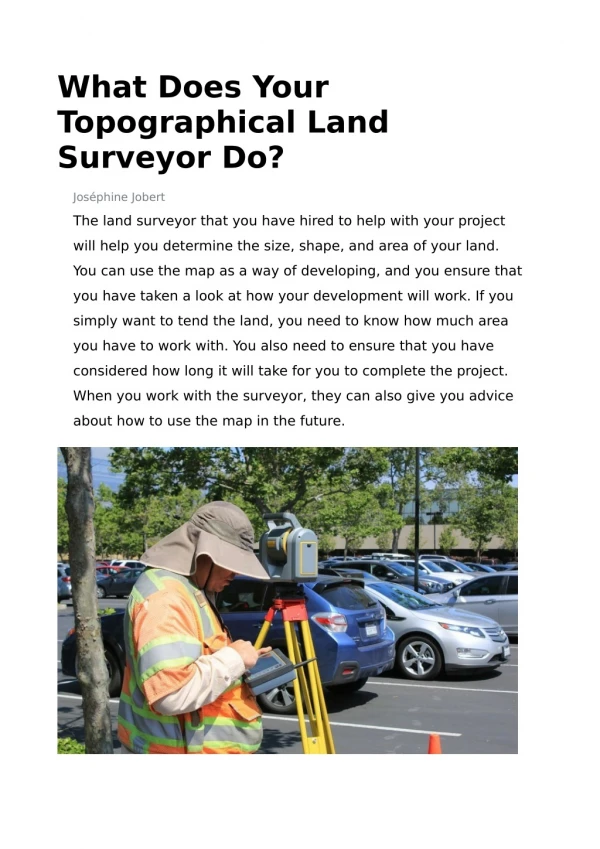
Land Surveyor OKC for Property Lines If you are planning a construction project, installing a fence, or simply wanting to know where your property ends and your neighbor's begins, obtaining a land survey is crucial. Knowing the precise location of your property boundaries can save you from legal disputes and ensure your projects proceed smoothly. This is where a land surveyor OKC comes into play, providing the expertise needed to determine these boundaries accurately. Types of Surveys for Defining Property Lines A land surveyor OKC can utilize several types of land surveying to define property lines, depending on the needs of your project. Boundary Survey This traditional survey method identifies the boundaries of a parcel of land. It involves detailed fieldwork and research into public records and previous surveys. ALTA Survey This is a detailed survey often required for commercial property transactions. The technician will map out boundary lines, improvements, utilities, and other elements. Subdivision Survey A subdivision survey is necessary if you plan to divide your property into smaller lots. This survey ensures the new lots conform to local zoning and subdivision regulations. GPS Survey This type of survey utilizes modern GPS technology and provides highly accurate positioning, making it ideal for large and remote properties. How a Land Surveyor OKC Measures Boundaries A land surveyor may use a combination of traditional methods and advanced technology to measure and capture data accurately. The process can look different depending on the specific survey being performed, but in general, the surveying process is as follows:
1. Research and Preparation Land surveyors begin by gathering existing data, including historical land records, previous surveys, and legal documents. This research provides a foundation for understanding the property's history and any existing boundary descriptions. 2. Field Surveying The next step involves on-site data collection. Surveyors use a variety of tools, including theodolites, total stations, and GPS survey equipment, to accurately measure and define the land and its boundaries. Using both traditional and modern techniques enables surveyors to pinpoint exact locations with a high degree of precision. 3. Data Analysis and Computation Once field data is collected, surveyors analyze and compute the measurements. They use specialized software to process the data and create detailed maps of the property. 4. Creating the Survey Map The final product is a detailed survey map that accurately depicts the property boundaries. This map is often accompanied by a report that explains the methods used and the findings. The Importance of Knowing Your Property Lines Whether you are embarking on a residential or commercial project, defining your property's boundaries with a survey can benefit you in more ways than one. Legal Clarity. One of the primary reasons to define property lines is to avoid legal disputes. Clear property boundaries help prevent conflicts with neighbors over land ownership, which can escalate into costly legal battles. ● Planning and Development. For civil engineering and construction projects, knowing the exact property lines ensures that all structures are built within the legal boundaries of the property. This is crucial for compliance with local zoning laws and regulations and helps avoid future legal issues related to encroachments. ● Property Value. Accurate property boundaries can enhance the value of your property by providing clarity and confidence to potential buyers should you decide to sell. ● Partner With Our Experts in Civil Engineering
and Land Surveying Defining your property lines is a crucial step in any land-related project. With the help of a professional land surveyor, you can ensure that your boundaries are accurately determined. At Sisemore & Associates, we pride ourselves on delivering accurate and reliable land surveying results to our clients. With over 25 years of experience, our team of expert surveyors combines extensive knowledge with cutting-edge technology to ensure precise and reliable property boundary definitions. Whether you need a boundary, ALTA, or GPS survey, our commitment to excellence ensures that your project will be in good hands. Please view our portfolio to see our past work, and reach out to start your project with us.