Download
1 / 19
190 likes | 262 Views
This article provides an overview of the WSR-88D Doppler radar, its operational features, history, key concepts, applications, and radar bands. It discusses Doppler effect, Rayleigh scattering, reflectivity, and radar equations. The text delves into radar signal processing, algorithms, and data products generated by weather radar systems. Additionally, it covers the significance of radar bands, making a signal, and the interpretations of returned radar signals. The article explores various radar applications, including real-time weather forecasting, precipitation estimation, wind shear detection, and storm structure analysis. It concludes with insights on radar products like base reflectivity, composite reflectivity, base velocity, and storm relative motion.

E N D
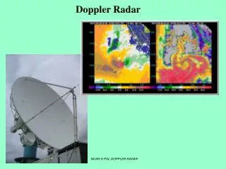
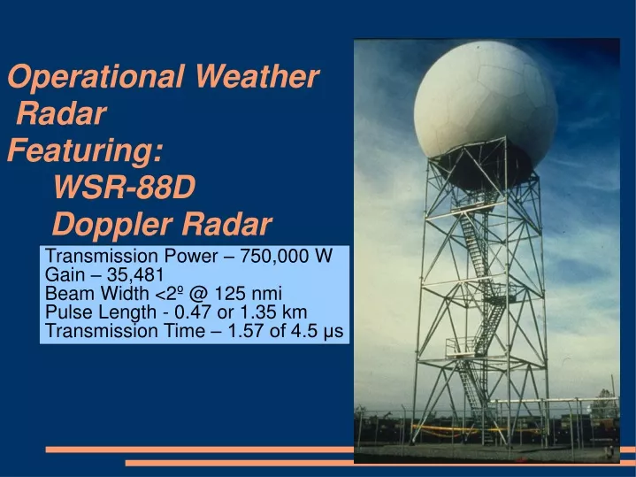
Operational Weather Radar Featuring: WSR-88D Doppler Radar Transmission Power – 750,000 W Gain – 35,481 Beam Width <2º @ 125 nmi Pulse Length - 0.47 or 1.35 km Transmission Time – 1.57 of 4.5 μs
DOWs measure record high wind speeds of 301 +/- 20 mph (135 +/- 10 m/s) in 03 May 1999 Oklahoma City tornado.
Abstract • Sensors • WSR88 – standard weather service radar • 158 Operational Sites Across the Country • Common Radar Bands: K,Ku, C,X, Ka • λ=1-10cm, 1-10x size of particles (rain ice) of interest • Makes use of Rayleigh Scattering • Phased Array Radar • Algorithms • Radar Equation • Attenuation
Brief Weather Radar History • ~1950: RADAR discovered • RADAR: RAdio Detection And Ranging • In early use, WWII military operators picked up on what they thought was noise • Really environmental returns, only noise if you want to see airplanes • 1950-1980: Continued development of reflectivity radar • 1980-2000: Invention and implementation of Doppler radar • As of 1988 the US started using 10 cm wavelength radars (WSR-88D) as their standard radar device for radar networks • 2000-present: Dual Polarization Radar and Phased Array Radar
Introduction • Key concepts • Doppler effect • Rayleigh scattering • Sensing the return • Reflectivity, dbz • Vertical cross section • Range Height Indication Scan • Constant Azimuth • Improvement with WSR-88D • Volume Scanning • Vary azimuth along with elevation • Optimally interpolate 3d volume or reflectance
Radar, Doppler and Raleigh • Radar Equation • Whn transmiter and reciever are in the same place, signal decreases in power to the fourth power • Doppler Equation • Where F’ = observed frequency, F = emitted frequency, v = velocity in medium, vs = velocity of source • Raleigh Scattering • EM radiation returned from a field with average particle size smaller than the wavelength of the radiation
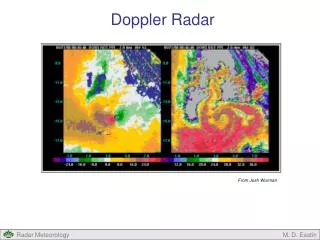
Reflectivity off a target • Power of the return signal - reflectivity (z) • z has the units mm^6/m^3 - • density of water droplets which would return the reflectivity • emissivity is implicit • To cover a large range it is often described in decibels • Intensity of the return echo helps determine the precipitation rate • significant precipitation usually is above 15 dBz • Reported reflectivity is an average of at least 25 pulses from a given azimuth and elevation
Applications • Nowcast/ short term forecast • useful for extreme weather • Easily deployed in remote locations • Lee Rotors • Precipitation Estimation • Links to related topics • RUCOOL Codar Maps • Radar Altimetry • Police Radar • Small Aircraft Detection • Benefits from radial movement of parts
Radar Bands and Uses • 2-4 S GHz, 7.5-15cm. Sirius and XM radio. Long range weather, marine weather, ATC • 4-8 Ghz - C band – satellite transponders, satellite TV, raw satellite communications, weather. • 18-27 Ghz - K - police, small drizzle/fog research • 27-40 Ghz Ka – police • 8-12 Ghz - X – airport radar – very long range, missile guidance
Making a Signal • The “listen” time (millisecond) is 1000x the pulse duration • This allows the radar an opportunity to be able to receive the signal again without interference from previous signals • Must wait until signal has reached maximum range and returned. • Knowing exact pulse travel time allows for calculation of the horizontal distance to the target • Intensity of the return, or backscatter -> target size • Radial Target Motion -> Doppler shift
What happens to the returned signal? • Must orient the returns (power at certain frequencies) into an accurate measure of precipitation • Measurements over a spherical volume are sliced up into horizontally and vertically to produce 2,3 and 4d visualizations • Account for ambient background noise
Algorithms • VIL • Vertically Integrated Liquid • HAIL • Estimates presence and size of hailstones • Potential Wind Gusts • Uses VIL, cloud top height • Estimates the winds under the cloud (ie downdraft) • Doppler measurement readily reveals wind shear storm relative velocity • Mesocyclone Detection Algorithm • Tornado Detection Algorithm • Wind Shear Detection (low level)
Products • Base reflectivity • how much precipitation is falling • precipitation type • assess a storm's structure and dimension • Composite Reflectivity • Scans from all elevations, imaging precipitation intensity and storm structure • Base Velocity • radial wind field, speed of fronts/strong wind • range of 140 mi • Storm relative motion • Track a circulation (show up well in doppler return) over time to determine storm motion. • Removing the storm relative motion from base radials gives an estimate of the flow with respect to the storm.
“Complications” • Migrating Birds • Insects • Aircraft, solid buildings, • large aerosols • for air traffic controller – rain • for meteorologist – airplanes. • Identification of snow, and snow type, • modification of observed matter before hitting the ground (fallstreaks) • big enough sample of precip for identification? • In precip estimates – Z-R relationship
Phased Array Radar Proven NAVY technology • Multiple beams with variable dwell times scan continuously • perform full volume scan every 20-30s • track cooperative aircraft • track non-cooperative aircraft • perform medium dwell scan on heavy cumuliform convection • perform long dwell scan on area of suspected tornadic development. • Expected that tornado warning could in to to 45 min
In Closing • Take precipitation rates with caution • Highly accurate under most conditions • Misleading in cases of extreme precipitation • The ultimate in nowcast and high resolution spatial time series for precipitation. • Extremely useful in adaptive forecasting of extreme weather events