Download
1 / 55
570 likes | 745 Views
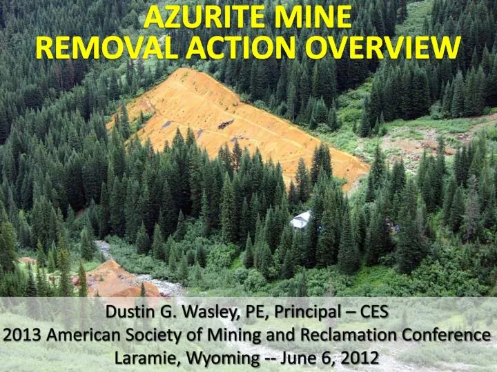
AZURITE MINE REMOVAL ACTION OVERVIEW. Dustin G. Wasley, PE, Principal – CES 2013 American Society of Mining and Reclamation Conference Laramie, Wyoming -- June 6, 2012. Azurite Mine Overview. Abandoned Underground Gold Mine, Located in North-Central WA on USFS-Administered Land

E N D
AZURITE MINEREMOVAL ACTION OVERVIEW Dustin G. Wasley, PE, Principal – CES 2013 American Society of Mining and Reclamation Conference Laramie, Wyoming -- June 6, 2012
Azurite Mine Overview • Abandoned Underground Gold Mine, Located in North-Central WA on USFS-Administered Land • Northwest of Mazama, Near Harts Pass Recreation Area & Pacific Crest Trail • Remote with Poor Access, Steep Terrain • Several RTE Species – Aquatic and Terrestrial • Inventoried Roadless/Non-Motorized Management Area • High Value for Potential Wilderness Area in Future
Azurite Mine Location AZURITE MINE MAZAMA
OVERVIEW OF AZURITE MINE FROM TINSON ADIT TAILINGS ~55,000 CY ~4 acres CADY PASS MILL AREA WASTE ROCK ~22,000 CY ~1 acre WENATCHEE ADIT MILL CREEK OFFICE BUILDING
Azurite Mine – Early History • 1915 – 31 Claims Staked • 1916 – Azurite Copper Company (renamed Azurite Gold) • 1918 to 1931 – Underground Development • 1934 – ASARCO Leased Mine • 1934 to 1936 – 100 TPD Mill and Infrastructure • 1936 to 1942 –Development, Production • ~73,000 tons @ 0.38 opt gold • 1942 – ASARCO Removes Equipment
Azurite Mine – Recent History • 1995 – Discovery Assessment (USFS) • 2002 – IAM Open File Report (WA DNR) • 2004/2005 – CERCLA Site Inspection (USFS/CES) • 2005 – Reprocessing Study (USFS/CES); – PRP Report (USFS) • 2006 to 2008 – EE/CA & Risk Assessment (ASARCO/MFG) • 2008 – ASARCO Settlement with USFS~$5.5M • 2007 to 2010 – Data Gaps/Removal Design (USFS/CES) • 2011 – Removal Action Activities
Final Removal Action Alternative • Access Road Improvements / Bridge Replacement (2010) • Temporary Access Road Across Mill Creek (2011) • Mill Creek Diversion Away from Waste Rock Pile (2011) • Onsite Covered Repository (2011) • Reinforced Stabilized Slope/Repository Toe Berm • Waste Rock and Mill Area Soil Blended with Tailings • Multi-Layer Cover, HDPE Membrane, and Talus/Rock Cover • Physical Hazard Closures (2011) • Revegetation (2011) – USFS Lead
Construction Challenges • Weather Conditions (rain, snow, heat)
Construction Challenges • Weather Conditions (rain, snow, heat) • Typical Construction Window (late June – early October) • Steep Slopes / Difficult Terrain • Limited Onsite Staging Areas • All Borrow Material from Onsite • Remote Access/Logistics/Communication
2011 Removal Action Summary • Turnkey “Design/Build” Contract Structure • CES – Prime Contractor • Palm Construction – Main Subcontractor (Local) • Mobilization – July 11, 2011 – 3 weeks late (weather) • Continuous Work Schedule, CES and Subs • Demobilization – September 26, 2011 – 1 week early
OVERVIEW OF AZURITE MINE REMOVAL ACTION TAILINGS PILE Contour with WR/Mill Soils, and Construct Repository STABILIZED SLOPE Construct to retain Repository WASTE ROCK Excavate and Haul to Repository MILL AREA Excavate and Haul to Repository
Camp, Equipment and Manpower • Remote Camp (internet, phones, running water, flushing toilets, showers, washer/dryer, cook, tents/campers) • 3 Excavators • 2 Loaders • 3 Dozers • 2 Off-Road, Articulated Haul Trucks • Roller Compactor, Water Truck, Misc. Work Trucks • Bear Proof Storage Containers • Manpower – 10 to 20 (Palm/Subs) / 1 to 3 (CES)
Erosion and Sediment Control • Run-On Ditches • Waste Rock / Tailings • Silt Fence • Borrow Area / Waste Rock • Filter Berms • Borrow Area / Waste Rock • Sedimentation Pond • Tailings / Repository
Mill Creek Crossing and Diversion • Access Waste Rock Pile, and Transport to Repository • Three, 48-inch CMPs • Temporarily Divert Mill Creek Away From Waste Rock Pile
Borrow Area Development • Onsite Source for Screening / 3 Products • 2-inch minus • Stabilized Slope Fill, Road Bed/Base, Fill Material • 40,000+ cubic yards used, more remains onsite • 2-inch to 36-inch • Repository cover, rocked diversion ditches • ~20,000 cubic yards • 36-inch plus • Misc. Placement, armoring
Underground Working Closures • Planned for 5 Closures (4 Adits / 1 Vent) • Pre-Cut Steel and Culverts Delivered to Site • Final Onsite Fabrication • Installation with Helicopter and Onsite Welder • 4 Closures • Burnham, Tinson, and Discovery Adits • Discovery Vent • Wenatchee Adit • Collapsed - No Bat Gate Installed
Reinforced Stabilized Slope • Designed to Stabilize/Retain the Repository • Original Design was 15-feet (H) x 15-feet (W) – 12 lifts • Final Layout was 22-feet (H) x 25-feet (W) – 17 lifts • Competent Soil Deeper Than Planned • Increased Quantities For Borrow Material/Geogrid • Onsite QA/QC Testing – All Final Tests Met Compaction Requirements (95% of Proctor) • 23 days to build • Bottom lifts ~ 1.5 days to complete • Upper lifts ~ 1 day to complete
Waste Rock Excavation and Placement • Design Estimate was 22,000 bcy of Waste Rock • Risk Assessment Cleanup Goal – 104 mg/kg Total Arsenic • Revised Cleanup Goal – 204 mg/kg Total Arsenic • Additional Background Soil Sampling • Used MTCA Stat 3.0 to Calculate Natural Background • In-Field Screening with Niton XRF (RPDs ≤ 33%) • Final Quantities ~ 16,500 bcy
Onsite Repository • Overall Slope = 2.5:1 • Reinforced Slope and Berm to Stabilize Repository • Waste Rock Blended with Tailings to Achieve Slope • In-sloped Benches Every 9 Vertical Feet • Repository Cover (Multi-Layer) • Talus/Rock Cover – Top • Geogrid • 12-oz Nonwoven Geotextile • 40-mil HDPE Membrane • 12-oz Nonwoven Geotextile • Waste Rock/Tailings – Bottom