Download
1 / 24
240 likes | 475 Views
United States and Canada. World Geography Mrs. Carter. Chapter 5. Landforms, Resources and Climate. The US and Canada are bordered on the North by the Arctic Ocean, to the West is the Pacific Ocean, and to the East is the Atlantic Ocean. Both are rich in natural resources.

E N D
United States and Canada World Geography Mrs. Carter
Chapter 5 Landforms, Resources and Climate
The US and Canada are bordered on the North by the Arctic Ocean, to the West is the Pacific Ocean, and to the East is the Atlantic Ocean. Both are rich in natural resources.
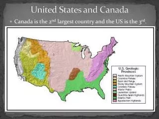
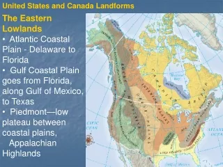
Eastern Lowlands- • flat, coastal plains along the Atlantic Coast and the Gulf of Mexico • excellent harbors • Appalachian Highlands- • Extends from Newfoundland in Canada to Alabama • Green, Catskills, Blue Ridge and Great Smokies • Not as high as the Rockies Landforms
Interior Lowlands • Mainly level land in the interior of N. America • Fertile soil • Interior Plains, Great Plains, Canadian Shield • Mississippi River runs through it • Western Mountains • Rocky Mountains: US & Canada- Continental Divide • Western Ranges: Cascades, Sierra Nevadas • Mt. McKinley in Alaska • Earthquake zone • Deserts, canyons, basins in between Landforms
Islands- • Canada- Ellesmere, Victoria, Baffin • US- Aleutian Islands (Alaska) and Hawaii Landforms
Since the US and Canada are bounded by 3 oceans they have important shipping and fishing industries. The large inland rivers and lakes serve as means of transportation, hydroelectric power and irrigation.
The Mississippi River is North America’s longest and busiest river system. Missouri and Ohio Rivers are tributaries.
Huron Ontario Michigan Erie Superior Great Lakes
The St. Lawrence and Great Lakes form one of the world’s busiest shipping routes. • Fertile land- North America is the world’s leading food exporter. • Vast forests- lumber industry- Pacific Northwest • Minerals and fossil fuels are abundant; allowed both countries to industrialize rapidly
people without a permanent home move from place to place Nomads
Land bridge that connected Russia and Alaska across the Bering Strait Beringia
Canada • French-speaking • Extreme cold in winter • Underground city to adapt to the cold Montreal
United States • Mild climate • Densely populated • Urban sprawl Los Angeles
Canals • Erie Canal- New York- man-made waterway that connects the Atlantic Ocean to the Great Lakes Types of Transportation
Rivers • St. Lawrence Seaway- a system of locks to connect the Atlantic Ocean to the Great Lakes • #1 shipping route- busiest Types of Transportation
Transcontinental Railroad • United States • Canada- East to West only • National Highway Systems • Canada- East to West only • United States- runs East, West, North and South connecting all parts of the US Types of Transportation
What is the continental divide? The highest point on the continent from which rivers will flow east or west. In the US, the continental divide is the Rocky Mountains. Question #1
In what type of climate would you expect to find permafrost? Tundra Question #2
How did the earliest inhabitants of the US and Canada, those who arrived before the Europeans, alter the land? Farming Question #3
What problems arose in Los Angeles with rapid expansion? Urban sprawl, lack of infrastructure Question #4
How did the settlers of the US and Canada overcome the distances across the continent? Railroads, highways, canals, rivers Question #5
Chapter 6 United States