Download
1 / 71
710 likes | 951 Views
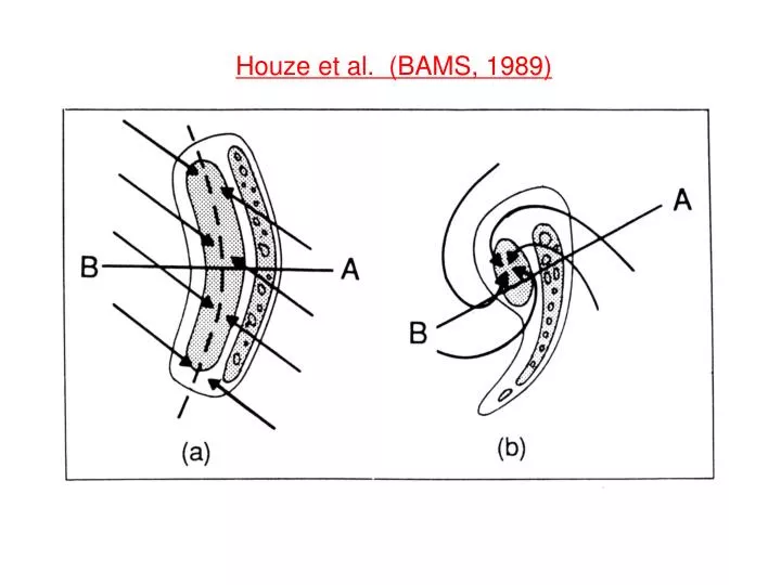
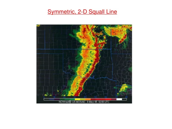
Houze et al. (BAMS, 1989). Houze et al. (BAMS, 1989). Johnson and Hamilton (1988). Basic Equations: 2D Squall Line. ⁄. *Also, no vortex tilting or stretching. --. Or, more simply, consider the 2D horizontal vorticity equation:. where. 2D Convective System Evolution:. C/∆u << 1.

E N D
Basic Equations: 2D Squall Line ⁄ *Also, no vortex tilting or stretching -- Or, more simply, consider the 2D horizontal vorticity equation: where
2D Convective System Evolution: C/∆u << 1 C/∆u ~ 1 C/∆u > 1 Weak shear, strong cold pool: rapid evolution Strong shear, weak cold pool: slow evolution
RKW Theory Rotunno et al. (JAS, 1988) C/∆u > 1 “Optimal”condition for cold pool lifting C/∆u = 1 C/∆u < 1
Rear-Inflow Jets: *Strength of Rear-Inflow Jet is proportional to CAPE
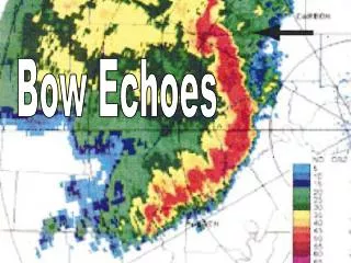
X Background and Definitions Mesoscale Convective System (MCS):an isolated, nearly contiguous region of thunderstorms, sometimes surrounded by an extensive region of moderate rainfall. Total size is usually 100-300 km across. Bow-echo:a bow-shaped line of thunderstorms often containing strong surface winds. Mesoscale Convective Vortex: a lower-mid-tropospheric horizontal wind circulation derived from an area of convection (often an MCS). 0600 UTC 10 June, 2003 200 km 0540 UTC 10 June, 2003 11 June, 2003
How can we systematically produce the observed line-end vortex pattern?
Line-end vortex mechanisms: Mature Phase:
Vortex Tube Circulation:
⁄ Vertical Vorticity: ⁄ …flux form ⁄ Circulation:
⁄ ⁄
…tilting of system-generated horizontal vorticity Rear-inflow jet (Davis and Weisman, 1994; Weisman and Davis, 1998; Davis and Galarneau, 2009)
Role of Line-End Vortices Focuses and Intensifies Rear-Inflow Jet
f-flux ⁄ f-flux
Derechos: Severe Lines of Thunderstorms • Damage from straight-line wind • Long swaths (> 400 km), long duration (> 6 h) • Wide damage swaths (100-500 km) • Rapid movement: 20-30 m/s Earthsky.org NOAA Storm Prediction Center Csmonitor.com
Derecho: (Johns and Hirt 1987) Large CAPE Moderate Shear
29 June 2012 Derecho: Composite Radar 03 UTC 00 UTC 18 UTC 21 UTC SPC Storm Reports
SUNY Albany 9 April 2014 The 8 May 2009 “Super Derecho”: 8-10 h of Hurricane-Force Winds, Extensive Damage… Radar 17:56 UTC 05/08/09 (Paducah) Morris Weisman NCAR/MMM Also: Lance Bosart, Clark Evans
Occluding Stage: 09 UTC (21 h) 11 UTC (23 h) 13 UTC (25 h) 15 UTC (27 h)
850 mb W (contoured) and Vertical Vorticity (shaded) 06 UTC 07 UTC 09 UTC 12 UTC 11 UTC 13 UTC
Vorticity Equation: Vertical Vorticity: tilting stretching
07 UTC 850 hPa Vorticity …Tilting… Stretching
08 May 2009 Derecho 900 hPa Horizontal Vorticity, SR Flow, W (shaded) With low-level jet from SW, streamwise horizontal vorticity evident in low-level environment….
29 June 2012 versus 08 May 2009 Derechoes 29 June 2012 …Cold-pool dominant …Descending rear-inflow …Cyclonic mid-level vortex Radar Reflectivity Model Reflectivity 08 May 2009 …Mesovortex dominant …Elevated rear-inflow jet …Warm-core vortex extending to surface
Cape/Shear Intercomparison: 29 June 2012 08 May 2009 CAPE: 2500-3500 j/kg Shear: 30-50 kts (15-25 ms-1) CAPE: 5000-6000 j/kg Shear: 20-30 kts (10-15 ms-1)
850 hPa Intercomparison: 08 May 2009 29 June 2012 NO Low-Level Jet, NO west-east boundary Low-Level Jet, west-east boundary, Lee trough
Summary: ….3 km WRF-ARW was capable of not only predicting the potential for two high-end Derecho events, but also was capable of distinguishing the differing mechanisms… 29 June 2012: Cold Pool dominant 08 May 2009:Mesovortex dominant ….These two cases may help clarify the differing environmental characteristics that contribute to these two archetypes: 29 June 2012: Extreme instability, modest unidirectional low-level shear 08 May 2009: Mid-trop baroclinicity, low-level jet, strong directional shear (streamwise at low-levels)
100-110KT winds at ~1kft Base Reflectivity 1334z KSGF
w, V z=3 km qr, V θ’ z=250 m US = 20/2.5 f=0 t = 4 hr no meso- vortices! continuous updraft 50 km
w, V z=3 km qr, V θ’ z=250 m US = 20/2.5 t = 4 hr locational bias 50 km
Vorticity Equation: Vertical Vorticity: …integrate along a parcel’s path: tilting stretching


![Climate Monitoring Products: BAMS experience Andrew Watkins [Australia]](https://cdn2.slideserve.com/4346849/slide1-dt.jpg)