Download

1 / 38
580 likes | 1.88k Views
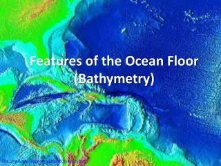
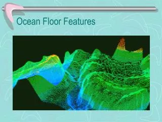
Ocean Floor Features. http://ga.water.usgs.gov/edu/waterdistribution.html. Source: Nace, U.S. Geological Survey, 1967 . East Coast of the U.S. How are the ocean floor features found?. SONAR. So und Na vigation R ange

E N D
http://ga.water.usgs.gov/edu/waterdistribution.html Source: Nace, U.S. Geological Survey, 1967
How are the ocean floor features found?
SONAR • Sound • Navigation • Range The echo sounder calculates water depth by measuring time between emission of a sound signal directed toward the ocean floor and the return echo.
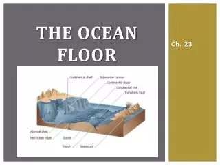
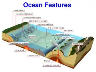
Topography of the Ocean Floor • Continental Shelf • Continental Slope • Submarine Canyon • Abyssal Plain • Seamount • Mid-Ocean Ridge • Rift Zone • Ocean Trench
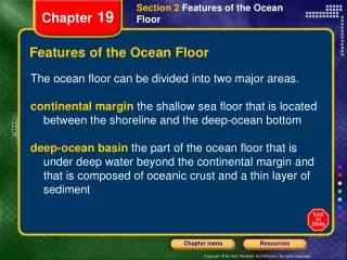
Continental Shelf & Slope • Continental shelf – a relatively flat part of the continent covered by seawater. Lies between the coast and the continental slope. • Continental slope – steeply dipping surface between the continental shelf and the deep ocean basin.
Continental Shelf & Slope San Francisco Monterey Bay The shelf break marks a distinct change in the slope of the sea floor from the flat continental shelf to the steep sea floor of the continental slope.
CONTINENTAL SHELF • About 8% of the global seafloor area • Source of fish, both commercial and sport, and in some areas, oil and natural gas. • Varies in size off the coasts of the U.S. • West coast – narrow • East coast - wide
CONTINENTAL SLOPE • Gradually rises from the abyssal plain but climbs as much as 45 degrees as it approaches land. • Continental Rise - sediment deposits at the base of the slope • Slopes are often gouged by deep valleys or submarine canyons
Submarine Canyon HUDSON CANYON CONTINENTAL SHELF CONTINENTAL SLOPE HUDSON CANYON - First discovered in 1864
Submarine Canyons San Francisco Canyon leading into Monterey Bay • Submarine canyons are v-shaped canyons cut into the continental slope. Many canyons are associated with major rivers such as the Congo, Hudson, and others. • most canyons were originally formed during the last Ice Age when the water level was lower • some are the result of earthquakes.
The true ocean floor Result of sediment drifting downward to fill depressions of the rocky ocean floor remains of marine life fine, clay-sized particles (ooze) ABYSSAL PLAIN
Abyssal Plain Continental shelf Continental slope Abyssal Plain The abyssal plain is the flat, almost level area of the deep ocean basin. OOZE!!!
Seamount seamounts Coast of central California Monterey Same area, different perspective A volcanic mountain found on an ocean basin. It is not a result of subduction or formed at the mid-ocean ridge. Possibly an island that has since eroded.
SEAMOUNT & GUYOT • Isolated mountains rising from 3,000 to 10,000 feet above the surrounding seabed. • Volcanic origin • Seamounts are found in all oceans, but are more numerous in the Pacific Ocean, with over 2,000 identified. • Guyots – flat-top seamounts
Map of Seamounts K. Stocks. 2003. Map of Sampled Seamounts. SeamountsOnline: an online information system for seamount biology. World Wide Web electronic publication. http://seamounts.sdsc.edu.
Mid-Ocean Ridge Mid-Atlantic Ridge Underwater mountain chain that rises from the ocean basins. Created by rising magma.
Map view showing sea floor spreading at the Mid-Atlantic ridge.
MID-OCEAN RIDGE • Several mid-ocean ridges are longer than the longest mountain ranges on Earth. • Can rise to above sea level to form islands • Iceland and the Azores - Atlantic Ocean • Galapagos Islands in the Pacific Ocean. • Most of the ridges crest at a depth of about 8,000 feet
MID-OCEAN RIDGE • Oceanic ridges have two peaks, separated by a rift valley. The valley ranges from 15 to 30 miles in width and contains an active seismic area. Americas Africa / Europe Example of the Mid-Atlantic Ridge
Rift Zone A system of cracks in Earth’s crust through which molten material rises. Rift zones are found in the middle of the mid-ocean ridges. Strange animal life and unique geologic structures have been found here.
Rift Zone • Divergent zones are where two plates are moving apart • Convection currents are rising, bringing up heat • Earthquakes and volcanic activity
29° N Volcanic ridge on zero-age crust, note small and larger volcanic cones. See cratered volcano at the top? The narrow, linear, bright features in the rest of the image are fault scarps. Uniform gray areas are sediment accumulating. Rift Zone
Trench A deep trough on the ocean floor where oceanic crust is forced below continental or other oceanic crust.
TRENCH • Found at subduction zones (near continents and island chains) • At least 26 trenches have been identified • 22 are in the Pacific Ocean • 1in the Atlantic Ocean (Puerto Rico Trench) • 1in the Indian Ocean (Java Trench)
TRENCH • Depths of major trenches exceed 18,000 feet, and vary from 10 to 22 miles in width. • The deepest is the Challenger Deep, 35,810 feet deep, in the Marianas Trench {Mount Everest - 29,028 feet} • Trenches are not the same: • Peru-Chile Trench off the west coast of South America is nearly 1,100 miles long. • The Japan Trench is 150 miles long and is the shortest. • The Tonga Trench, located between New Zealand and Samoa, is the narrowest and straightest. • The Kurile Trench between Japan and Kamchatka is the widest.