Download
1 / 9
90 likes | 233 Views
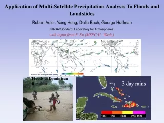
Multi-satellite Precipitation Analysis (MPA). George Huffman, Bob Adler, Dave Bolvin, Eric Nelkin NASA/GSFC. Theory / Schematic. Algorithm Inputs. Calibrate High-Quality (HQ) Estimates to “Best”. Instant-aneous SSM/I TRMM AMSR AMSU. 30-day HQ coefficients. Merge HQ Estimates.

E N D
Multi-satellite Precipitation Analysis (MPA) George Huffman, Bob Adler, Dave Bolvin, Eric Nelkin NASA/GSFC
Theory / Schematic • Algorithm Inputs
Calibrate High-Quality (HQ) Estimates to “Best” Instant-aneous SSM/I TRMM AMSR AMSU 30-day HQ coefficients Merge HQ Estimates 3-hourly merged HQ Match IR and HQ, generate coeffs 3-hourly IR Tb 30-day IR coefficients Apply IR coefficients Hourly HQ-calib IR precip Merge IR, merged HQ estimates 3-hourly multi-satellite (MS) Compute monthly satellite-gauge combination (SG) Monthly gauges Monthly SG Rescale 3-hourly MS to monthly SG Rescaled 3-hourly MS Theory / Schematic (cont.) • Algorithm Process • The “real” MPA is the post-real-time Version 6 3B42 • The current real-time 3B42RT that runs 10 hr after real time is a first look • We plan to replace the 10-hr run with a 4-hr “early” and 7-hr “final” to better support operations
Theory / Schematic (cont.) • IR Calibration Data Cube • 3-hr/0.25° matched HQ and IR, aggregated for a month on overlapping 3°x3° blocks
Theory / Schematic (cont.) • Strengths and Weaknesses of Underlying Assumptions • “All” MW are used • Aggregating MW to 3-hr maps introduces time errors at fine scale • Intercalibration of MW and cal. of IR to MW traceable; good, except bad if the calibrator goes bad • Different calibrators are used for RT (TMI) and V.6 (TCI and gauge) • VAR scheme for IR assumes that instantaneously colder clouds rain more • VAR scheme for IR takes calibration from a month of data; stable, but stiff • HQ-VAR combination scheme is priority - HQ, else VAR; minimum assumptions, but introduces boundaries
Theory / Schematic (cont.) • Planned Modifications / Improvements Current (3 February) • Update the RT VAR calibration coefficients every 3 hr (vs. 5 days) • Introduce AMSR, AMSU in RT in addition to TMI, SSM/I • Just recomputed February–May due to programming, uh, feature Short-term • 10-hr latency lowered to 7-hr in RT (the “final”) • Introduce “early” 4-hr RT Long-term • Approximate TCI and gauge calibrations for RT (so closer to V.6) • Ameliorate or audit out deficient input data in light-rain, cold-surface areas • High-latitude estimates based on NASA SRT TOVS and AIRS • Fine-scale error estimates (REM2D?) • Evaluate CST to replace VAR • Evaluate B1 (and TOVS, OPI) data to extend back in time
Algorithm Output Information • Spatial Resolution 0.25°x0.25° • Spatial Coverage 50°N-S (60° possible) • Update Frequency 3-hr (RT), monthly (V.6) • Data Latency 10 hr (RT; plan move to 7 & 4), 2 weeks after month (V.6)
Algorithm Output Information (cont.) • Source of Real-Time Data • Source of Archive Data
Algorithm Output Information (cont.) • Capability of Producing Retrospective Data (data and resources required / available) • Currently 1/98-present (but already based on heterogeneous input data) • Could go back to 10/96 with current data sets • Likely able to go back to 1/91 by employing B1 data • Figuring out how to handle the F8 drop-out would allow us to go back to 7/87 • Properly handling TOVS and/or OPI as calibrators might take us back to 1983 • At coarser resolution, might be able to go back to 1979