Download
1 / 74
740 likes | 861 Views
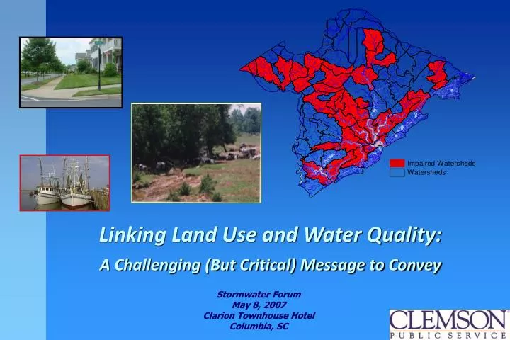
Linking Land Use and Water Quality: A Challenging (But Critical) Message to Convey. Stormwater Forum May 8, 2007 Clarion Townhouse Hotel Columbia, SC. Are You At the Top of the Org Chart…?. Ever Feel Overloaded…?. Ever Get Mixed Signals…?. Ever Required to Consider Economics…?.

E N D
Linking Land Use and Water Quality: A Challenging (But Critical) Message to Convey Stormwater Forum May 8, 2007 Clarion Townhouse Hotel Columbia, SC
Ever Been Confronted with What Might Have Been a Poor Decision…?
Overview • Working with Local Officials • Tough audience • NEMO Strategy • Comprehensive planning • Site design • Best Management Practices
Facts About Local Officials • Most are volunteers • Limited training
Facts About Local Officials • Complex issues • Politically motivated
Facts About Local Officials • Regulator vs. administrator • High turnover
Reaching Local Officials • Focus on rational decisions • Present information in context of responsibilities • Watch informational material overload
Reaching Local Officials • Reconcile regulations with comprehensive plans • Continuity of message • Follow up!
Reaching Local Officials • Understand legal roles and responsibilities • Address site and “big picture” issues • Don’t be afraid of saying “I don’t know”
Logistical Tips • Use local data and information • Use humor…they need every bit they can get! • Use latest technology
Nonpoint Education for Municipal Officials Linking Land Use to Water Quality in South Carolina
SC NEMO Goal Develop a process to educate elected and appointed municipal officials about the impacts of land use on water quality and about options available for managing those resources
EPA and NOAA SC Sea Grant Extension Program Clemson University Extension BCD Council of Governments Ocean and Coastal Resource Management USC Center for Environmental Policy USC Earth Science and Resources Institute Waccamaw Council of Governments Community Decision-Makers
Nonpoint Source Pollution Point Source Pollution Photo: AM Johnson
Major Watersheds in South Carolina BROAD CATAWBA SALUDA PEE DEE SAVANNAH EDISTO SANTEE SALKEHATCHIE
10% 55% 50% 15% Development Impacts On the Water Cycle
Land Cover or Land Use? Cover - what is physically on the ground - Forested - Wetlands Use - what is practiced, permitted or planned - Recreational
What to Look For: • Polluted runoff from • Forested & Wetlandareas Nutrients: Pathogens: Sediment: Toxic: Debris: Thermal: wildlife erosion from timber harvesting removal of streamside vegetation
What to Look For: • Polluted runoff from • Open and Agricultural Areas Nutrients: Pathogens: Sediment: Toxic: Debris: Thermal: fertilizer from farms, parks, golf courses pet & wildlife waste erosion from agricultural fields pesticides from farms & golf courses litter & illegal dumping removal of natural vegetative buffers, shallow water impoundments
What to Look For: • Polluted runoff from • Residentialareas Nutrients: Pathogens: Sediment: Toxic: Debris: Thermal: lawn fertilizers & septic system effluent malfunctioning septic systems, pet waste construction, road sand, erosion from lawns & gardens household products, pesticides litter & illegal dumping heated runoff, removal of natural vegetative buffers
What to Look For: • Polluted runoff from • Commercial & Industrial areas Nutrients: Pathogens: Sediment: Toxic: Debris: Thermal: acid rain and car exhaust malfunctioning or overloaded septic systems & lagoons construction, road sand, roadside erosion auto emissions, industrial pollutants litter & illegal dumping heated runoff, removal of natural buffers
Wait a minute Cal. All that material can be so overwhelming. What can I really do to address stormwater?
Three-tiered Strategy for Coping with Polluted Runoff 1st:Natural Resource Based Planning (Community Scale) 2nd: Site Design (Community & Site Scale) 3rd: BMPs & Remediation (Site Scale)
Strategy for coping with polluted runoff 1st:Natural Resource Based Planning 2nd: Site Design 3rd: BMPs & Remediation • Inventory natural resources • Prioritize areas for protection and for development • Incorporate open space planning • Develop plans of action • Revise zoning and land development regulations to support plans
COMPREHENSIVE PLAN ELEMENTS Cultural Resources Population Comprehensive Plan Economics Land Use Housing Community Facilities Natural Resources
For ExampleSuggested Language for Local Ordinances The Town of _____ wishes to protect the health of its water resources, and seeks to reduce the impact of development on those resources. In particular, the commission requires that all new or re-development projects : 1. Consider it’s location within the watershed 2. Minimize disturbance of natural grades and vegetation 3. Protect natural wetlands and stream buffers. 4. Maximize infiltration of stormwater 5. Minimize impervious surfaces.
Planning for Open Space • Encourage incentives & flexibility to promote conservation of water and land resources • Conduct Open Space (Natural Resource) Inventory • Prioritize for preservation • Categorize open space by function • Organize into corridors or greenways
Strategy for coping with polluted runoff 1st:Natural Resource Based Planning 2nd:Site Design 3rd: BMPs & Remediation • Reduce impervious area • Contain stormwater on-site
Site Design Strategies Reduce Impervious Area • Reduce Road Widths – Alternative street lay-outs, one way streets, queuing streets, back alleyways for utility infrastructure and parking, setbacks, alternative materials • Reduce Parking Area –Lower allocation ratios, angled parking, narrower slots • Alternative Driveway Design – Shared driveways, lot frontage setbacks, pervious materials • Reduce Paved Sidewalk Area – On one side of street only, alternative materials
Site Design Strategies Contain Stormwater On-Site • Use inverted streets as stormwater collectors – Bio-filters • Invert parking islands to collect water • Reduce use of street curbing – Grassed or vegetative swales • Direct rooftop runoff from gutters onto pervious areas
Site Plan Review The Impervious Surface Budget Parking Lots Roads Driveways Sidewalks 65% Transportation 35% Structures Offices Stores Houses Patios Derived from the City of Olympia, WA ISRS Final Report
Shoulder/swale= 12’ R.O.W. = 48’ Pavement = 24’ Subbase Pavement Width can be much less than the right-of-way
Right-of-Way Widths Paved right-of-ways contribute a significant amount to the imperviousness of a community. Redesign the main components of the ROW by: • Narrowing roadways • Reducing sidewalk widths or restricting sidewalks to one side of the street • Requiring ROWs be permeable (grass, dirt, permeable pavement) • Reducing the border width between the street and the sidewalk • Installing utilities under street pavements • Placing sidewalks and utilities within easements outside of the ROW
Local Collector 18 to 24 feet Arterial 22 to 30 feet 24 to 32 feet Street Lengths and Widths Streets are the greatest source of impervious cover in most subdivisions. Vary pavement width according to the proposed use A hierarchy of road standards