Download
1 / 58
590 likes | 783 Views
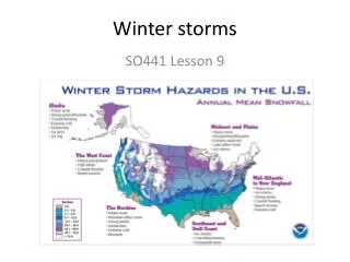
Topographic Forcing and Front Range Winter Storms. 24-25 October 1997 Front Range Blizzard and Blowdown in WY/CO/NE/KS Doug Wesley Winter Weather Workshop, August 2002. OUTLINE. Topographic forcing in the context of a strong Front Range winter storm, 24-26 Oct. 1997

E N D
Topographic Forcing and Front Range Winter Storms 24-25 October 1997 Front Range Blizzard and Blowdown in WY/CO/NE/KS Doug Wesley Winter Weather Workshop, August 2002
OUTLINE • Topographic forcing in the context of a strong Front Range winter storm, 24-26 Oct. 1997 • Eta and Meso-Eta forecasts • RAMS forecasts • Advantages of improved NWP resolution in these types of storms • Influence on precipitation fields of small-scale terrain features and larger-scale wind fields
Terrain reliefj:/shared/for_wesley/canada/NorthAmerica….bmp • Rocky Mountain barrier; Colorado region has probably the highest continuous N-S barrier in North America • Relatively lower “plains” to the north • East-west ridges on the “plains” • Source region of modified arctic air masses
Idealized portrayal of effects of terrain on winds • http://meted.ucar.edu/mesoprim/flowtopo/index.htm (pp. 1-2, 4-9)
Lee-side eddies/convergence • “Longmont Anticyclone”
Lee eddies (cont’d) • “Denver convergence-vorticity zone”
Eta and meso-Eta model terrain • AWIPS: 2 grids; 40 and 80 km grid spacing, although model is currently running at 12 km • GARP: 80 km plotted grids utilized for Eta in 1997 (model data computed at 48 km) • Misses many major terrain features • Smoothness of N-S cross section
J. Steenburgh’s findings • http://www.met.utah.edu/jimsteen/imtn2001/imtn_wkshp_2001_files/v3_document.htm
RAMS model terrain • 3 grids: 15, 5, 1.7 km
Storm overview/synoptics • Upper levels: deep, intensifying cutoff low pressure system over the four corners region and eastward • Influx of cold low-level air from north • Timing of above 2 factors favorable • Result was intense upslope flow for 12+ hours over the Front Range of the Rockies
Eta 36 hr. accum. precip. at 00Z 26 Oct.; simulation began at 00Z 24 Oct.
Eta 36 hr. accum. precip. at 00Z 26 Oct.; simulation began 12Z 24 Oct.
Meso-Eta 24 hr. accum precip. at 00Z 26 Oct.; simulation began at 15Z 24 Oct.
CSU RAMS Mesoscale Model Characteristics ·Non-hydrostatic ·Nesting capable ·Terrain-following vertical coordinate ·Microphysics: Mixed-phase; predicts cloud droplets, raindrops, pristine ice crystals, snow, aggregates, graupel, hail. . (Generalized gamma distribution used for each) ·Eta (forecast) boundary conditions for this study ·Grid spacing for this study: 15, 5 and 1.67 km
RAMS QPF • Grid 1 • Grid 2 • Grid 3 • Precip. rates compared with observations at Jeffco… “R1” means full microphysics package
Northeast of Steamboat Spgs., CO(sometime after 26 Oct. 1997)
Wind predictions/verification • Observed: mountain wind gusts to 50 m/s on western slope • Meso-Eta: 25 m/s aloft, no amplifying wave (less than 10 m/s at lowest levels) • RAMS 5 km grid: ~25 m/s @ 50m; amplifying mountain wave • RAMS 1.7 km grid: ~30 m/s @ 50m and > 40 m/s aloft; generally ~33% greater speeds; evidence of rotors and non-linear wave dynamics