Download
1 / 23
230 likes | 423 Views
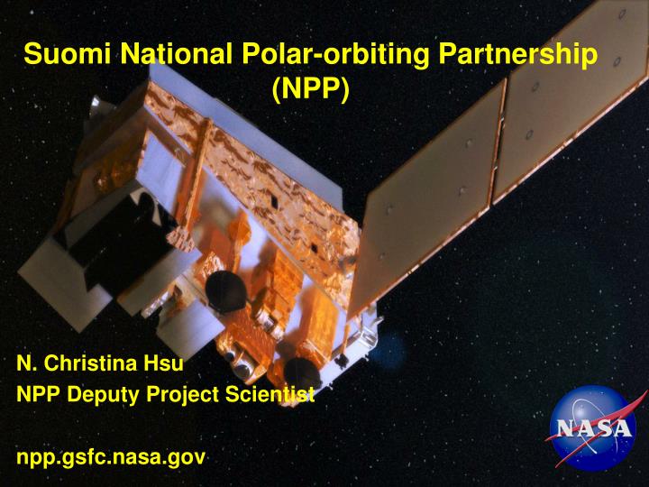
Suomi National Polar-orbiting Partnership (NPP). N. Christina Hsu NPP Deputy Project Scientist npp.gsfc.nasa.gov. NPP Mission: Make Environmental Observations. Provide Data for Weather Forecast Models Short term Environmental Observations (Events) Long term Environmental Observations

E N D
Suomi National Polar-orbiting Partnership (NPP) N. Christina Hsu NPP Deputy Project Scientist npp.gsfc.nasa.gov
NPP Mission: Make Environmental Observations Provide Data for Weather Forecast Models Short term Environmental Observations (Events) Long term Environmental Observations (Climate Change Detection)
NPP with 5 instruments 13.2 ft long 8.5 ft wide 4,500 lbs VIIRS CrIS ATMS OMPS CERES
Space Segment NPP Direct Broadcast User Launch SupportSegment NPP System Architecture GPS TDRSS WSC LEO & A Backup T&C AFWA Central NESDIS Central Science Data Segment Land PEATE Command, Cntrl & CommSegment I/F Data Proc Segment Ocean PEATE SD3E Data Del Data Del Ozone PEATE GSE - Svalbard Primary T&C NPP SMD DQM I&TSE Process Process Infra Infra Atmos PEATE NICSE Data Mgt Data Mgt Ingest Ingest Sounder PEATE Archive & Dist Segment Ingest • Mission Mgmt Center - Suitland • Flight Operations Team • • Enterprise Management • • Mission Management • • Satellite Operations • • Data Monitoring & Recovery Archive Interchange Datastore Data Handling Node Inventory RoboticStorage Archiver Data Routing & Retrieval NPP Mission Data Command and Telemetry Key: Climate User Community MSO - 4
Visible Infrared Imaging Radiometer SuiteRaytheon SAS El Segundo, Ca • Description • Purpose: Global observations of land, ocean, & atmosphere parameters at high temporal resolution (~ daily) • Predecessor Instruments: AVHRR, OLS, MODIS, SeaWiFS • Approach: Multi-spectral scanning radiometer (22 bands between 0.4 µm and 12 µm) 12-bit quantization • Altitude: 824 km VIIRS on NPP
General Characteristics for VIIRS Granule • Temporal coverage: ~86 seconds • Resolution: 375 m at nadir for 5 I(imagery-resolution) bands and DNB • Resolution: 750 m at nadir for 16 M(moderate-resolution) bands • Swath: ~3000 km • Numbers: ~70 granules/orbit, ~100 minutes/orbit, ~1000 granules/day • Equator crossing: ~1:30 pm local time
VIIRS Bands and Products VIIRS 22 Bands: 16 M_ Band, 5 I_Band and 1 DNB VIIRS 24 EDRs Land, Ocean, Atmosphere, Snow Dual gain band * Product has a Key Performance attribute
Monitoring Disasters:Deepwater Horizon Oil Slick April 29, 2010
Smoke Plumes from New Mexico Fires May 25, 2012 The large New Mexico fire complex, referred to as the Whitewater-Baldy fire, was observed by VIIRS at 2017 UTC on May 25th. As of June 1st, the fire had burned 197,333 acres.
Progression of Dust Storm over Southwest Asia: 3 overpass from Terra, NPP, to Aqua
VIIRS Chlorophyll-a Data Overall Performance(Results Consistent with MODIS-Aqua) Slide courtesy of Menghua Wang and Ocean Color Team.
VIIRS vs. MOBY In Situ 412 443 486 555 671 • VIIRS OC data compared with the MOBY in situ data, showing that SDR data since 2/6/2012 are good and reasonable, before that SDR date were poor/not reliable. • VIIRS ocean color products are good and reasonable from 2/6/2012. • Vicarious calibration is needed and will further improve ocean color products. Data from M. Wang MOBY PI: Ken Voss
VIIRS SDR Thermal Bands : SST Night time SST from U Miami RSAS Evans/Minnett SST bias ~ 0.45K
Sea Ice: The Shifting Crust of the Southern Ocean(M. R. Drinkwater and J. C. Comiso – ESA, NASA GSFC) VIIRS Products: sea ice temperature, characterization, snow cover/depth Ross Sea ice jams the channel where the mighty B-15A iceberg broke apart in October 2003 Photo by Brien Barnett, NSF
Resolution Improvements: OLS vs. DNB • 740 m instantaneous geometric field of view (DNB) from VIIRS vs. ~5 km for the OLS from DMSP results in dramatic spatial resolution improvements. • DNB Imagery courtesy of Steven Miller CIRA/CSU
Resolution Improvements: OLS vs. DNB • 740 m instantaneous geometric field of view (DNB) from VIIRS vs. ~5 km for the OLS from DMSP results in dramatic spatial resolution improvements. • DNB Imagery courtesy of Steven Miller CIRA/CSU
Questions? VIIRS Anomaly
VIIRS M05/M04/M03 (red/green/blue) VIIRS M15 (10.76 microns) color scaled from 225K to 325K 19 January 2012
VIIRS M07 (0.865 microns) grey scaled19 January 2012 • VIIRS Data Anomaly highest in this band • Degradation in M7/I2 observed after launch. • Smaller effect in M6 & M5. • Commissioning paused while anomaly was studied. • Degradation believed to be caused by an error in mirror coating process. An inadvertent layer of tungsten film was put on telescope mirrors. • Commissioning resumed Jan 18 • Degradation is slowing, should level off. • No effect on VIIRS data products; • VIIRS Signal-to-Noise (SNR) in M7 expected to be above spec.
VIIRS Degradation Prediction 4-mirror thin-layer model
NPP Instrument Status: VIIRS SDR • All band are producing excellent images with expected quality • All onboard calibrators (BB, SD, SDSM) are functioning normally, providing good quality data for SDR calibration • Reflective Solar Band (RSB) LUT have been successfully updated on-orbit; • VIIRS SDR Inter-comparisons show good agreement with Aqua/MODIS after the LUT updates • Thermal Emissive Bands (TEB) response is stable, and consistent with pre-launch analysis
Questions? Fishing boats