Download
1 / 28
310 likes | 382 Views
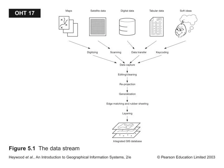
Explore the three primary methods for digitizing spatial information: Manual Methods (Tablet and Heads-up Digitizing) and Automated Methods (Scanning and Vectorization). Discover the steps involved in digitizing paper maps, tools like digitizing tables and electronic mesh, tips for careful planning, and the benefits of topology in GIS operations. Learn about on-screen digitizing, Raster to Vector Conversion, Rubber Sheeting, and the importance of Topology. Find out about GPS, field survey data, and data collection methods like geocoding and conflation. Discover data format exchange and the role of Data Interoperability for efficient GIS data transfer.

E N D
Digitizing • There are three primary methods for digitizing spatial information: • Manual Methods include: • Tablet Digitizing • Heads-up Digitizing • An Automated Method includes: • Scanning and Vectorization
Manual Digitizing Ref: Getting Started with GIS, by K. Clarke
How is it done? • Although methods vary, the typical steps for digitizing a paper map require the following: • Physical Preparation • Digitizer Set up • Map preparation • Digital Preparation • Map registration • Digital Collection • Feature collection • Feature correction • Save, save, save
Creating New Data (Cont’d) • Manual Digitizing: • Digitizing tables used (tedious process) • Electronic mesh senses cursor position • Paper maps (e.g. Topo Maps) are sources of most GIS themes that we use • Point or stream mode digitizing done • Now-a-days mainly done in 3rd world • Need to record ref. coor. converted to real-world coor. (GIS coverage) • Digitizing polygons need labels (ID) • Careful planning needed before you digitize
Heads up Digitizing • Digitizing and scanning
Scanning Ref: Getting Started with GIS, by K. Clarke
Creating New Data (Cont’d) • Scanning: • Scan a map into binary grid file • Can be converted back to vector thru tracing (i.e. line thinning extracting topo-reconstruction or smoothing) • Software available to clean scanned images • Resolution is an issue (e.g. a line = 5-6 pixels) • Digital maps are as good as the source map
Creating New Data (Cont’d) • On-Screen (head-up) Digitizing: • Relatively easy to do • Good for updating/editing changes • You can add points, lines, polygons • You don’t have to register points as in manual digitizing • Geometric Transformation: • Digitized maps have same coor. As source map • You may have to convert to real-world coor. & projection using control points.
Raster to Vector Conversion • Able Software R2V • AutoDesk Raster Design • ESRI ArcScan
Rubber Sheeting: Spatial database editing software that attempts to correct errors by stretching a map to fit known control points or monuments.
Why Topology Matters • Topology allows automated error detection and elimination • Need to build/clean topology for digitized/scanned maps • Unconnected nodes are snapped • Slivers from digitizing are eliminated • Topology makes map overlay feasible • GIS operations are done w/o accessing the point files
Why do I want Topology? Gaps and slivers Overshoots and undershoots
Non-Topology Ref: Introduction to GIS by K. Chang
Creating New Data • Remotely sensed data • Georef; 1m x 1m resolution; good as a background map for other themes Ref: Getting Started with GIS, by K. Clarke
Creating New Data (Cont’d) • GPS: differential GPS have cm-scale resolution • Measures ranges (distances of receivers by 24 NAVSTAR satellites using radio signals & atomic clocks) • Ref. or base stations can reduce noise • Diff. GPS comes w/ software to download data • Hand-held GPS data can be downloaded too Ref: Getting Started with GIS, by K. Clarke
Creating New Data (Cont’d) • Field Survey Data: • defines parcels by azimuth & distances • Uses Total Station, Stadia, Laser Ranging, and COGO software Ref: Getting Started with GIS, by K. Clarke
Methods of Collecting Data • Existing data, downloads from field • Keyboard • COGO
Creating New Data (Cont’d) • Street Addresses: • Point features, street segment length, even/odd house numbers with side descriptions (e.g. TIGER files) can be geocoded • TEXT Files: lat/long in dec. degrees cane converted to an event theme Ref: Getting Started with GIS, by K. Clarke
What is Conflation? • the process of transferring attributes from a source line layer based on one level of accuracy and precision to a target line layer of a different precision and accuracy.
Format & Exchanging of GIS Data • Can import different data formats or use utility programs (e.g Import 71) to convert data • GIS accept TIF, GIF, JPEG, AutoCAD data formats (needs right extensions) which are not georeferenced • Vector to Raster conversion is easy, opposite is hard • Data exchange by import/export involves errors in attributes & geometry • ESRI New Product called Data Interoperability • Efficient data transfer is important for the future of GIS • OpenGIS® Specifications on • GML Geographic Markup Language • WMS Web Map Service • WFS Web Feature Service