Download
1 / 22
410 likes | 1.19k Views
Township & Range System in the US . Public Land Survey System (PLSS) . What is it? A way of subdividing and describing land in the United States. All lands in the public domain are subject to subdivision by this rectangular system of surveys

E N D
Public Land Survey System (PLSS) • What is it? • A way of subdividing and describing land in the United States. • All lands in the public domain are subject to subdivision by this rectangular system of surveys • Regulated by the U.S. Department of the Interior, (BLM). • The used to divide public domain lands, which are lands owned by the Federal government . • The original public domain included the land ceded to the Federal Government by the thirteen original States, supplemented with acquisitions from native Indians and foreign powers.
History of Land Partitions in the U.S. • Each colony, except New England, used a different method for locating land claims. • Conflicting means of granting land, conflicting means of locating claims lead to a system of confusion and conflict. • Western Lands • Many states claimed part of the land west of the Appalachian mountains. • No common reporting system or place lead to overlapping boundaries and claims. • Individuals wanted access to cheap, small parcels. • Claim descriptions often used the metes and bounds system. • Led to the Land Ordinance of 1785.
Metes and Bounds • This system describes property lines based on local markers and bounds drawn by humans, often based on topography. • Lines are described with respect to natural or artificial monuments and baselines defined by these monuments. • The metes and bounds survey is based on a point of beginning, an established monument. • Used by early English settlers, reason for weird shapes of the original colonies. • Directions are bearing angles measured with respect to a previous line in the survey.
Metes and Bounds (cont.) • "From the point on the north Beginning at the mouth of a branch at an ash stump thence up the creek south 20 poles to 2 beach, thence east 41 poles to a small walnut in Arnett's line, thence north 50 east 80 poles to a linn hickory dogwood in said line, thence north 38 poles to an ash, thence west 296 poles with Potts's line till it intersects with Tolly's line, thence south 30 west 80 poles to a whiteoak and sugar, thence east 223 poles to beginning
Long Lots • French government tried to transplant a form of feudalism to North America • French settlers were more interested in the fur trade than farming, so lots were laid out to give maximum access to the rivers • Each lot had a fairly narrow frontage on the river, but extended far back from it. • Each was subdivided into long narrow strips that were only 350 to 600 feet wide but ten times as deep. • At the back end of the strips a road ran parallel to the general course of the river, and this road provided the frontage for a second range of strips when the first range was fully occupied.
Land Ordinance of 1785 • Also known as the Northwest Ordinance • The immediate goal of the ordinance was to raise money through the sale of land in the largely unmapped territory west of the original colonies. • The Land Ordinance established the basis for the Public Land Survey System (PLSS). • Land was to be systematically surveyed into square townships, six miles on a side. • Each of these townships was sub-divided into thirty-six sections of one square mile or 640 acres (259 hectares). • These sections could then be further subdivided for sale to settlers and land speculators. • The ordinance was also significant for establishing a mechanism for funding public education. • Section 16 in each township was reserved for the maintenance of public schools.
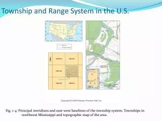
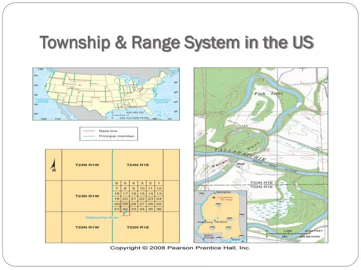
PLSS • Also known as Township and Range • Developed to subdivide and describe land in the United States. • Key Terms: • Initial point • Base line • Principle meridian • Parallels • Guide meridians • Quadrangle • Township • Section • Closing corners
INITIAL POINTS • In each area an initial point is established by astronomical observations. • There are 35 Principal Meridians in the public lands systems based on 37 initial points. • From each initial point a true north-south line called a principal meridian is established to the limits of the area to be covered. • From each initial point a true east-west line called a base line is established to the limits of the area to be covered.
Base Lines and Principal Meridians • Principal Meridian • A principal meridian was established that followed a longitude through the initial point. • Only one principal meridian was used for each survey. • The principal meridian is a continuous line • Base Line • A base line is an east-west line established through the initial point and at 90o to the principal meridian. • Base lines are curved because they are equal distance from the poles. • They are parallel to the equator.
PARALLELS AND MERIDIANS • Parallels are run as true parallels of latitude 24 miles apart north and south of base line. • Standard parallels are numbered consecutively north and south of the base line, e.g. Second Standard Parallel North. • Meridians are run as true meridians 24 miles apart east and west of the principal meridian • Guide meridians are numbered consecutively east and west of the principal meridian, e.g. First Guide Meridian East.
Closing Corner • Because each guide meridian is established at 90o to the standard parallel, there is an offset where each guide meridian joins the next standard parallel. • This is the Closing Corner • As the survey moves North of the base line, the offset of the closing corner increases because the meridians converge at the north pole.
QUADRANGLES, RANGE AND TOWNSHIP LINES • An area with the boundaries of two parallel and two meridians is called a quadrangle. • A quadrangle is divided into townships by running range (R) and township (T) lines. • Range lines are true meridians running north at 6 mile intervals on the base line and standard parallel lines. • Township lines are true parallels established at 6 mile intervals on the principal meridian, guide meridians, and range lines.
Townships • Each quadrangle is divided into 16 townships. • Each township is 6 miles square. • Townships contain 36 sections. • Each vertical column of townships is called a range. • Each horizontal row of townships is call a tier. • The identification of the township in the illustration is T5S, R6E.
Sections • The 36 sections in each township are numbered in serpentine fashion starting at the north east corner. • The section number is used in the description
Section (cont.) • Each section can be subdivided. • The subdivisions are limited to fractions of 1/4 and 1/2. • Irregular parcels can be identified by lot number.
Labeling the Grid • A: N1/2, NW1/4, S27, T7S, R15W, IM, OT • B: E1/2, NE1/4, S27, T7S, R15W, IM, OT • C: NW1/4, NW1/4, SW1/4, S27, T7S, R15W, IM, OT • D: NE1/4, SW1/4 & N1/2, SE1/4, SW1/4, S27, T7S, R15W, IM, OT • or: N1/2, SE1/4, SW1/4 & NE1/4, SW1/4, SW1/4, S27, T7S, R15W, IM, OT • E: SE1/4, SE1/4, SE1/4, S27, T7S, R15W, IM, OT • F: N1/2, NE1/4, SW1/4 & N1/2, NW14, SE1/4, S27, T7S, R15W, IM, OT • or: N1/2, NW1/4, SE1/4 & N1/2,NE1/4, SW1/4, S27, T7S, R15W, IM OT • G: S9, T7S, R15W, IM, OT • H: T8S, R16W, IM, OT • I: N1/2, SW1/4, S20. T8N. R14E, IM, OT • J: SE1/4, NW1/4, NE1/4, S20, T8N, R14E, IM, OT • K: NE1/4, SE1/4, NE1/4, NE1/4, S20, T8N, R14E, IM. OT